Elevation: 5,104 ft
Prominence: 254
This peak is not in the book. Ken Jones and Livingston Douglas provided the information for this peak. Livingston’s is the most up-to-date information, especially with regards to access. Updated November 2023
Bear Den Butte is the highest point in Minidoka County. It is located in the southwest corner of the Craters of the Moon National Monument. While this butte lacks 300 feet of prominence, its status as the Minidoka County High Point ensures that it is often visited. If you make it to this peak, you might also want to visit nearby Lava Butte. USGS Bear Den Butte
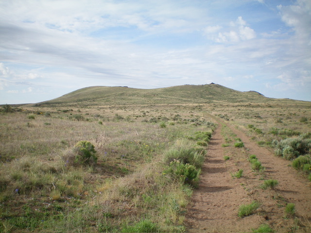
Bear Den Butte as viewed from the north. The summit is left of center. Cairned Point 5092 is right of center. Livingston Douglas Photo
North Face and Northwest Face Routes by Livingston Douglas
Access
Same as for Lava Butte. This is the second leg of a 2-peak adventure that includes Lava Butte and Bear Den Butte. This journey covers 8.5 miles with 700 feet of elevation gain and does not require any difficult driving conditions.
Please note that the access roads from Carey are in quite good condition. If you choose to drive via the Bear Den Butte Spur Road, you must have good tires as it crosses sharp lava rock for a brief section. If you drive south from Laidlaw Park Road to South Park Well and then east to skirt below Lava Point (avoiding the lava fields) and continue east then northeast to the east side of Bear Den Butte, BLM told me (in 2022) that the roads to Bear Den Butte are maintained here and are in good condition. This is contrary to the horror story told on the website which probably does apply to the southern road approaches which are pretty rough.
Map Errors
The USGS topo map fails to show the spur road that head southeast from Bear Den Butte Road to a good 2-track road that heads west then south from Lava Butte. The USGS topo map shows a 2-track road heading north into Little Laidlaw Park from a junction on Bear Den Butte Road. That road no longer exists.
North Face, Class 2
The Climb
From Bear Den Butte Spur Road on the west side of Lava Butte, follow the road south toward Bear Den Butte. Leave the road where it bends left/southeast. Scramble south up a shoulder/face in a mix of grass, tumbleweeds, and sagebrush to reach the northwest ridge. Follow the ridge crest in easy, short scrub to the bare summit hump of Bear Den Butte. There is no summit cairn.
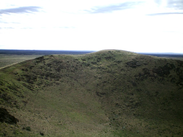
The summit hump of Bear Den Butte as viewed from Point 5092 to its west. Livingston Douglas Photo
The gentle, bare summit of Bear Den Butte, looking west at cairned Point 5092 (dead center). Livingston Douglas Photo
Northwest Face, Class 2
The Descent
From the true summit, follow the crater rim northwest then west then southwest to Point 5092, the [lower] west summit of Bear Den Butte. This point, ironically, has a tall cairn atop it. From Point 5092, descend north then northeast to return to Bear Den Butte Spur Road. The terrain on the northwest face is steep scrub with some underlying loose volcanic talus/scree. It is much rougher than the north face ascent route. Once back on Bear Den Butte Spur Road, follow it north then northwest back to the parking pullout at the 0.3-mile point.
Ken Jones Trip Report
Access
Google Maps will provide directions from either Carey, Idaho or Kimama, Idaho. Nevertheless, the butte is not easy to reach. It is located in unforgiving, rugged desert country and should only be visited by experienced desert travelers. A 4WD is recommended. The condition of the Carey-Kimama Road can vary significantly from year to year. Check with BLM for current conditions before driving it. The side road that leaves the Carey-Kimama Road at the Laidlaw Corrals airstrip and leads to the butte is not frequently maintained. Lava rock along the way can shred tires. In wet conditions, you may encounter huge, muddy puddles.
CAUTION: Google Maps does not warn you that the Carey-Kimama Desert road is not suited for anything short of high-clearance vehicles. Early in the spring I used 4WD high in several spots and my high clearance was often put to the test. There were at least 15 spots where the road was covered with deep-water mud holes, which required using rough detours. There was one sandy stretch that was difficult to navigate, even in 4WD high. This is remote, difficult country. As an alternative to Google Maps, Ken Jones provided the following detailed driving instructions from the south and I-84.
Leave I-84 at Exit 208 and head north on ID-27 to Paul, Idaho. Continue north (the road is now 600 W) to ID-24 (about 14 miles from I-84) (Mile 0.0). Head north across a railroad track (a BLM sign north of the track indicates “South Park Well 26” and another discourages through traffic to Carey).At 1.3 miles, follow the main road as it curves right, then bear left at 1.8 miles. At 2.8 miles (junction with road 700 N), continue straight ahead (north).
Please note that many of the labels for these roads in my DeLorme Idaho Road Atlas (1992 edition) do not match the road signs. I use the actual road signs in this write-up. In what follows, not all junctions are mentions, but any that might be confusing or useful as landmarks are included.
Stay on main road, passing a track left at 5.9 miles and a main junction with destroyed signs (probably Bear Trap Cave Road) at 9.1 miles. Pass another fork left at 13.7 miles, and find still another at 15.3 miles by a landing strip. Stay right on the main road, and continue straight past a major sharp left fork around the end of the strip at 15.5 miles. The main road is easy to follow, past a right fork at 15.6 miles and lefts at 18.6 miles, 20.6 miles, 21.7 miles, and 22.5 miles.
You’ll cross a cattle guard at 23.1 miles and pass forks right at 23.4 miles and left at 24.3 miles. The mapped shortcut at about 24.8 miles was not found at either end. At 26.5 miles, you’ll be just south of a couple of buildings at South Park Well. Take the first right fork here. Keep right at a T-intersection at 27.9 miles, and bear left on the better fork at 29.0 miles.
Cross another cattle guard at 29.4 miles and keep left at the fork at Point Lake (29.9 miles). You’ll skip a jeep trail right at 32.8 miles. Bear Den Butte has been obvious for a number of miles. The high point is the smooth, rounded summit to the east. The sharp rock pillar on the western summit is actually a cairn. At 35.0 miles and several more times in the next 0.5 mile, you’ll pass jeep tracks left. These enter a Wilderness Study Area, and even though one set appears to lead to the summit, it is not recommended to drive them. At 35.5 miles, there is a BLM sign identifying Bear Den Butte, and a left fork at 35.6 miles. Go left and park when you like the approach to the summit (about 0.25 to 0.5 mile).
Route, Class 2 by Ken Jones
From the parking spot, walk cross-country directly to the summit. A stroll around the crater rim to the West Summit is recommended, but not required. The East Summit is definitely the high point.
Additional Resources