Elevation: 10,140 ft
Prominence: 1,360
Climbing and access information for this peak is on Page 324 of the book. Livingston Douglas has provided us with a massive three-route update covering this interesting peak. All three routes are potential first ascents. Check it out and you will itching to climb this 10er.
Please note that the book shows this peak at 10,125 feet while the more recent USGS data shows the peak at 10,140 feet. USGS Reservoir Creek
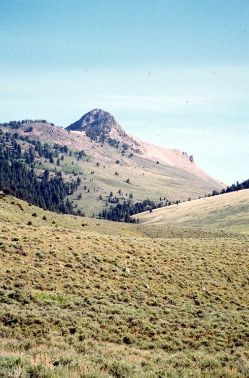
Conical Top Peak as viewed from Dry Creek.
Conical Top Peak by Livingston Douglas
Access
Dry Creek Trail [(B)(6.3)(b) on Page 329] as revised and updated. FST-188/Dry Creek Trail begins as an overgrown, two-track road (Dry Canyon Road). It starts at the junction of Powderhorn Gulch Road and Dry Canyon Road at an elevation of 6,975 feet.
East Ridge, Class 3
The Climb
The book is correct that Dry Creek Road/Trail has a gate closure at the National Forest Boundary approximately 0.7 mile up the road. Dry Creek Trail climbs Dry Creek Canyon but only very briefly. Both the book and the USGS quadrangle are inaccurate in stating/showing that “the trail is in relatively good condition and climbs to a saddle in 2.5 miles.” In actuality, Dry Creek Road has been closed to vehicles for a long time and is pretty much gone soon after the gated closure. Worse yet, there is no trail after that. You must bushwhack up the canyon and use cattle trails as available.
From the junction of Powderhorn Gulch Road and Dry Canyon Road (6,975 feet), hike 0.7 mile up the unmarked, weak, overgrown two-track road (Dry Canyon Road) to the National Forest Boundary and gated road closure. Pass through the gate and follow the drainage in a northeasterly direction. The road disappears almost immediately and there is no trail. Bushwhack up the dry drainage, staying mostly on its left/west side. This is not a difficult bushwhack as the terrain is primarily sagebrush. In some sections, you will find cattle trails to help expedite your ascent. Scramble through open terrain to reach a marshy basin at approximately 8,150 feet. There is a cistern here for the cattle. A cattle trail will help you navigate your way across the spring-fed marsh. The cattle trail is on the right/east side of the marshy basin.
This basin sits at the bottom of a triple-fork in the drainage. The left fork aims directly at the upper reaches of the East Ridge of Conical Top Peak, but is far too steep and loose for climbing. The center fork leads directly up to a 7,980-foot saddle at the base of the East Ridge of Conical Top Peak. Unfortunately, this fork is clogged with thick sagebrush and is not a good option. The right fork heads away from the mountain in an easterly direction and is also clogged with thick sagebrush.
The best option is a steep shoulder that separates the left fork and the center fork. Follow a cattle trail briefly up out of the marsh and along the left/west side of the center fork. Leave the cattle trail and climb up a steep, loose scree/sagebrush slope to access the shoulder. Once on the shoulder, grind your way north on steep scree to reach the East Ridge at approximately 9,150 feet. This ridge entry point is about 350 feet above the prominent saddle at the base of the East Ridge. Mark this point with a cairn so that when you return, you don’t pass by it—the shoulder is not obvious when standing on the ridge.
Follow the ridge west to the summit of Conical Top Peak. Initially, the ridge is grass/tundra/broken rock and goes quickly. You’ll cross a flat section of ridge where there is cattle fencing laying on the ground. You may even see some elk crossing this mini-saddle (as I did). At the 9,600-foot level, skirt a rocky ridge outcrop on its right/north side (Class 3). A little farther up, scramble up a boulder field to reach the base of the summit cliffs/headwall. Follow a climber’s trail on the left/south side of the headwall that climbs a minor gully. After a final ridge section of ledge-climbing, you will reach the summit ridge. Scramble briefly on Class 3 boulders to reach the rocky perch that is the top of this rugged peak.
From the summit, the South Ridge looks pretty choppy (Class 3-4 at a minimum) and I was happy to avoid it. In the process of climbing the East Ridge, you will notice that the North Ridge looks quite choppy as well. And, if you plan to do the traverse to Bull Peak (as I did), you may be dismayed by what you see. To learn more about the traverse from Conical Top Peak to Bull Peak, please consult the West Face/North Ridge Route description.
West Face/North Ridge, Class 3
The Descent
This route is part of a ridge traverse from Conical Top Peak to Bull Peak. Upon returning from Bull Peak, I used a different route to get back to the East Ridge of Conical Top Peak—the North Ridge/East Face Route (Class 3). It is an alternative option to the West Face/North Ridge Route. Please note that the “connecting ridge” route from Conical Top Peak to Bull Peak is rated Class 3 difficulty (as per page 324 of the book). It is not Class 3, in my opinion. It’s much more difficult than that, at least for the North Ridge of Conical Top Peak portion of it.
From the rocky summit of Conical Top Peak, briefly descend the North Ridge. The narrow North Ridge quickly turns into a Class 4/5 nightmare of ridge towers and serious exposure. Enough of that. Descend down a steep, rotten chute on the West Face. From the bottom of the chute, do a gradual descending traverse across boulders, talus, and scree to reach the gentle, grassy saddle (9,400 feet) that connects Conical Top Peak to Bull Peak. The side-hilling traverse on the West Face is not much fun, but it goes at Class 3 in difficulty. It is much easier than the full North Ridge option.
North Ridge/East Face, Class 2+
The Ridge Traverse
This route is part of a ridge traverse from Bull Peak back to the East Ridge of Conical Top Peak. It is an alternative option to re-climbing Conical Top Peak via the West Face/North Ridge Route (Class 3). From the gentle 9400-foot saddle connecting Bull Peak to Conical Top Peak, climb southeast from the saddle to reach the North Ridge at a prominent flat area (9,620 feet). Follow the North Ridge briefly, until reaching the steep towers that dominate its upper reaches. Exit the North Ridge here and drop onto the East Face via a rotten, loose scree chute.
After a 150-foot descent down the crumbly chute, begin a rising traverse on the East Face of Conical Top Peak. This side-hilling endeavor is mostly on boulders initially. Thankfully, the terrain changes over to grass/tundra then finishes on talus. The ups and downs on this route are as follows: Up 275 feet, Down 150 feet, Up 350 feet. You will intercept the East Ridge of Conical Top Peak at approximately 250 feet below the summit. Please be advised that the USGS quadrangle makes this ridge traverse look much easier than it actually is.
Descend the East Ridge then leave the ridge to descend a shoulder back down to the Dry Creek Canyon floor. Please refer to the East Ridge Route for Conical Top Peak for more details on this descent route.
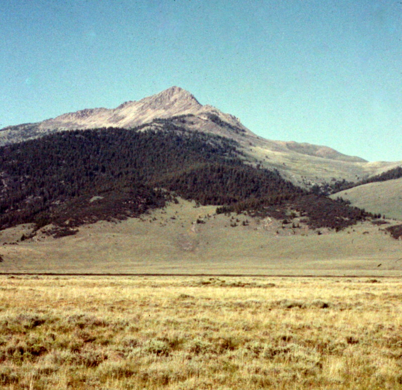
Conical Top Peak as viewed from the west.
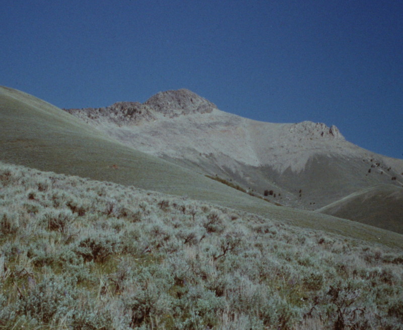
Another view of Conical Top Peak from the west.
Additional Resources
Regions: Beaverhead Range->EASTERN IDAHO
Mountain Range: Beaverhead Range
First Ascent Information:
- Other First Ascent: East Ridge, North Ridge/East Face and West Face/North Ridge
- Year: 2017
- Season: Summer
- Party: Livingston Douglas