Elevation: 10,194 ft
Prominence: 1,303
Climbing and access information for this peak is on Page 323 of the book. I identified the [lower] North Summit as Elk Mountain and this peak as Horse Prairie Peak because (1) there are too many Elk Mountains in Idaho, (2) the high point is the site of the Horse Prairie BM and (3) Horse Prairie is a much more unique name. To avoid future confusion, I am reverting back to the name used by the Board of Geographic names.
Livingston Douglas has provided updated access and route information (below) to help you reach the summit.
Elk Mountain is a Beaverhead Mountain that sits on the Continental Divide. It has the “Horse Prairie” USGS benchmark embedded on its summit. Elk Mountain is part of a long ridge identified as “Elk Mountain” on the USGS quadrangle. The Continental Divide Trail traverses its ridge line and provides good access, albeit with a long route to the summit. USGS Deadman Pass
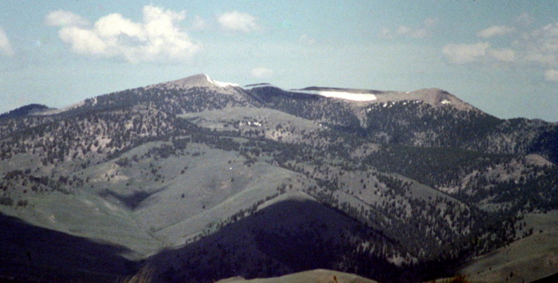
Horse Prairie Peak as viewed from Baldy Peak.
Elk Mountain Update by Livingston Douglas
Elk Mountain is identified as Horse Prairie Peak on Page 323 of the book. This peak is actually called Elk Mountain and is shown as such on the Deadman Pass quadrangle. It is also called Horse Prairie Benchmark as a USGS benchmark labeled “Horse Prairie” is embedded in a ground boulder atop the peak. Lists of John (LOJ) confirms these names for this peak.
Access
Hall Creek Road [(B)(5.1)(a) on Page 329]. Access for Elk Mountain is revised and updated as follows. From Bannock Pass, drive south on ID-29 for 5.3 miles. Turn left/east onto Cruikshank Road/FSR-130 and reset your odometer. At 2.2 miles, turn left onto Frank Hall Creek Road at a signed junction. At 4.1 miles the road is permanently closed and gated. It is best to park at an informal campsite about 0.1 mile prior to the gate closure since there is no parking area at the gate. Elevation at the gate closure is 7,360 feet.
Ignore the book’s reference to Hall Creek Trail since any climb of the West Ridge of Elk Mountain begins at or before Hall Creek Trail/FST-191. My version of the West Ridge Route begins at the road closure gate.
West Ridge, Class 2
The Climb
From the gate closure on Frank Hall Creek Road, walk past the gate and cross to the north side of a narrow gully. Climb steeply north out of the gully and up a face that is a combination of loose scree and sagebrush. This is the steepest part of today’s journey, but at least the terrain is open. The slope eases a bit as you gain altitude and, after a grueling 700 feet of uphill, you will reach the West Ridge of Elk Mountain. The terrain is still sagebrush, but that will soon change. Thankfully, the slope is much tamer than what you’ve experienced so far on this climb.
Hike up through open sagebrush terrain to reach the forest. Upon reaching the pine forest at about 8,500 feet, scramble east up the ridge through open forest with some navigation around blowdown required. Climb up to the top of Point 9195, a rocky outcrop with a good view of what lies ahead. Drop to a saddle and then climb up over a small ridge hump. Drop to another saddle and climb up to the top of Point 9273. Drop to a third/final saddle and, soon after that, you will reach tree line.
From tree line, scramble up a talus/scree combo to intersect the Continental Divide Trail (CDT) where it crosses the West Ridge of Elk Mountain. There is a large USFS sign here stating “Elk Mountain” and offering mileage figures for both the north and south routes of the CDT. Cross the CDT and continue eastward up the final 100-foot section of ridge talus to reach the small summit of Elk Mountain. You will find a USGS Benchmark labeled “Horse Prairie” embedded in a summit boulder. The summit also has an ID/MT Boundary Post secured in a large cairn.
North Ridge, Class 2
The Descent
This route is part of a ridge traverse from Elk Mountain to Peak 10153. Consequently, it begins on the summit of Elk Mountain. Descend north from the summit on reasonably stable talus/scree to quickly access the CDT on the left/west side of the first saddle you reach. Follow the CDT northward as it skirts the west side of a couple of ridge points. Where the trail weakens, you will find large cairns to guide you. But this is very open terrain on a ridge crest, so navigation is not an issue. The second major saddle that you reach is at 9,820 feet. This saddle is the low point between Elk Mountain and Peak 10153. Peak 10153 is incorrectly called “Elk Mountain” in the book when, in fact, it is an unnamed peak.
Additional Resources
Regions: Beaverhead Range->EASTERN IDAHO
Mountain Range: Beaverhead Range
Longitude: -113.13789 Latitude: 44.75989