Elevation: 10,323 ft
Prominence: 783
Climbing and access information for this peak is on Page 322 of the book.
Monument Peak was the first Beaverhead Mountain that I climbed in 1978. I was almost hit by lightning. My route is set out in the book. Livingston Douglas climbed the northwest face and descended the southwest ridge of Monument Peak in 2017. His routes are set out below. Monument Peak is unique in that it is both a ranked Idaho peak (#342) and a ranked Montana peak (#304). USGS Homer Youngs Peak
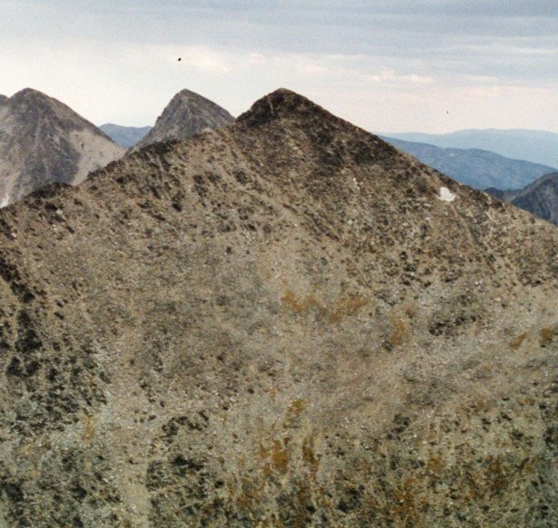
Monument Peak as viewed from Freeman Peak.
The summit of Monument Peak looking toward Freeman Peak and showing the MT/ID 472.066 Mile Marker. Rick Baugher Photo and Commentary
Northwest Face, Class 3 by Livingston Douglas
After an unsuccessful attempt at the southwest ridge of Freeman Peak (getting as high as 9,650-9,700 feet), and not wanting to go back to camp with my tail between my legs, I attempted the northwest face of Monument Peak. It had been calling me all morning. It looked so close and appeared to be doable.
I descended 700 vertical feet down a rotten, steep gully on the South Side of the Southwest Ridge of Freeman Peak. Here, I reached the upper basin of the North Fork Kirtley Creek drainage. I crossed the small inlet stream above the unnamed lake in this basin at about the 9,000-foot contour line.
Skirting to the right of a prominent finger of snow that extended to the base of the Northwest Face, I starting climbing the Northwest Face of Monument Peak, aiming for a flat, saddle-like area on the West Ridge at 10,060 feet. The Northwest Face was a Class 3 endeavor with a mix of steep talus, minor cliff bands, and minor gullies. I had to skirt large snowdrifts on the north side of the west ridge to finally access the [beloved and easy] ridge. It was then an easy Class 2+ scamper to the gentle summit.
I descended the Class 2 Southwest Ridge of Monument Peak (which from the summit is initially a west trending ridge that soon turns southwest) and dropped off the Southwest Ridge at about 8,400 feet to descend to the North Fork Kirtley Creek. I crossed the creek at about 7,650 feet. Then I scrambled up the steep tundra slopes of the South Side of the Southwest Ridge of Freeman Peak to reach the ridge crest and then descended back to my camp along Freeman Creek Road.
Southwest Ridge via Freeman Peak’s SW Ridge Route, Class 2 by Livingston Douglas
Access
The Kirtley Creek Road Access [(B)(1) on Page 328] is currently blocked by private property. Worse yet, private property extends about 1/3 of the way up the Southwest Ridge of Monument Peak. Consequently, though 4WD jeep roads that cross the desert terrain do exist, driving across them to the base of Monument Peak’s Southwest Ridge via Geertson Creek Road is not an option either. Please consult the Salmon-Challis NF/Salmon National Forest Map to see the private property coverage of the lower section of Monument Peak’s Southwest Ridge. Contact the BLM/FS office in Salmon, Idaho for more current updates. Fortunately, there is a way to avoid the privately-owned land.
The publicly-accessible approach is via Freeman Creek Road [(A)(3.1) on Page 328]. From the junction with Carmen Creek Road, turn R/E and drive up Freeman Creek Road for 2.9 miles to a fork in the road (5,349 feet). Park in the grassy field on the S side of the road (2WD). Please be aware that horse owners often park here and disembark to go horseback riding, so they need room to turn their horse trailers around to return back down to Carmen Creek Road. If you have a 4WD with decent ground clearance, you can drive up the unmarked right fork for 1-1/2 miles (stay L at an umarked road junction early on) to where the road reaches the mouth of a short drainage that is squeezed between the Freeman Creek drainage and the NF Kirtley Creek drainage. This is the 4WD parking area. The parking area here is limited to only 1-2 vehicles.
The Climb
From the 2WD parking area at the fork in Freeman Creek Road, hike S up a jeep road for 1-1/4 miles to a sharp L turn at a cattle fence, stay L at an unmarked road junction early on. Continue hiking another 1/4 mile on this road, passing an old jeep road on the L side that goes up a heavily forested drainage. Stop at a cattle gate where the road now enters private property. From the 4WD parking area, hike 100 feet W (away from the drainage) to reach the cattle gate. The cattle gate is where your road hike ends and your adventure begins. No more roads or trails for you until you return here later in the day. Please note that the placement of the jeep roads (after leaving the 2WD parking area) are inaccurate on the Badger Spring Gulch quadrangle.
Since you won’t be entering the rancher’s property, you do NOT need to sign in at the cattle gate [the rancher allows public access to the private road during certain hours of the day when he has the gate unlocked and open]. Please observe that there is a large cattle pond to the W of this gate. Make a mental imprint of what it looks like because it is a helpful navigational tool when you descend off the Southwest Ridge of Freeman Peak to find your way back to this point. This cattle pond appears on the Badger Spring Gulch quadrangle.
You are currently standing at the base of the Southwest Ridge of Freeman Peak at just over 6,000 feet in elevation. The game plan is to climb Freeman Peak’s Southwest Ridge for a ways, drop into the North Fork Kirtley Creek drainage, cross it, then climb E up onto Monument Peak’s Southwest Ridge, then follow the Southwest Ridge to the summit of Monument Peak. The easiest part of this climb is Monument’s Southwest Ridge, a gentle Class 2 endeavor that can be ascended on horseback to the summit. The hard part is getting there.
Follow the left side of the cattle fence steeply upward on the edge of a forest. The fence row ends about 350 vertical feet up from the road and you must circumvent it via a minor cliff band where there is a gap between the end of the fence and the rocky cliff band. This point is about 50 feet to the left of the main fence line that you’ve been ascending.
Once above the cattle fence, continue up the steep grass, staying to the climber’s right of the forest. After another 200 feet of uphill, you’ll reach the better-defined, wide Southwest Ridge of Freeman Peak. It’s wide open terrain here and you’ll enjoy the views and the climb. Just remember where this point is (either by GPS or altimeter) because you need to return this way on your descent and you don’t want to mistakenly overshoot this point. Turn around and look down at the cattle pond, which is now over 500 vertical feet below you. That visual identification will help you in the descent back to the jeep road.
Unless you want lots of thistles in your socks, put on a pair of gaiters here. Turn left-ish to follow Freeman Peak’s Southwest Ridge higher. Stay to the R/S of the tree line. Though the grassy terrain is a bit thick and cumbersome at times, it’s probably better than wrestling with deadfall in the forest. Follow the ridge E to Point 7930, a rocky outcrop on the ridge. This is a critical ridge point to remember. The ridge turns left-ish here and climbs NE instead of E. Two ridges join here: the one you climbed and the one that descends S to Kirtley Creek Road. When you return here later in the day, remember to turn L/W here to descend the proper ridge.
From Point 7930, climb up through some forested areas on the ridge. The ridge terrain changes back to sagebrush/tundra in the 8,000-foot to 8,250-foot area. [NOTE: I continued up the Southwest Ridge of Freeman Peak from here, in an attempt to climb it to the summit of Freeman Peak. After failing in that attempt, I descended to the upper reaches of the North Fork Kirtley Creek drainage and climbed the Northwest Face of Monument Peak. I descended the Southwest Ridge Route on Monument Peak and returned to Freeman Peak’s Southwest Ridge at the 8,250-foot level.]
The open terrain on Freeman’s Southwest Ridge is the point from which to begin an easterly, diagonal descent to the North Fork Kirtley Creek drainage. From here, get a good look at the Northwest Face of Monument Peak’s Southwest Ridge. Establish your line of ascent now (or during your descent to the creek) because you will lose visibility down near the creek due to the forested nature of the Northwest Face of the Southwest Ridge of Monument Peak. Your objective is to cross the North Fork Kirtley Creek at the 7,600-foot level and reach Monument’s Southwest Ridge at a flattish ridge section at 8,350 feet. Notice the imposing cliffs on the left-side of the ridge face. When climbing up through the moderately-steep forest, if you err then err to the climber’s right rather than the climber’s left.
Leave Freeman Peak’s Southwest Ridge in the 8,000-foot to 8,250-foot area (my descent route put me back on Freeman Peak’s Southwest Ridge at 8,250 feet) and descend in an easterly direction. This is a diagonal, descending traverse and involves side-hilling on steep sagebrush/tundra. Thankfully, you are in open terrain and you will have elk trails to help you as the terrain steepens lower down. Aim for a creek-side meadow at 7,600 feet (visible on the Homer Youngs Peak quadrangle). Since the terrain steepens as you near the creek, you won’t see this meadow until you are right on top of it. You might even disturb a large herd of elk in the creek-side meadow, as I did. This is a remote place that sees little human activity.
After reaching the North Fork Kirtley Creek (7,600 feet), bash your way through the thick brush and blowdown to reach the far side of the creek drainage. Make your way up through the moderately steep forest in a southeasterly direction. When you reach the Southwest Ridge of Monument Peak, your hard work is over. Turn around and take a look down at the creek-side meadow from whence you came. When you return to this spot on the ridge, that meadow will help you establish your line of descent back down to the North Fork Kirtley Creek. You will also get an excellent view of the open terrain leading from the meadow back up onto Freeman Peak’s Southwest Ridge. Yes, you will have to ascend 650 feet or so to get back up onto Freeman Peak’s Southwest Ridge. But at least you’ve avoided encountering an angry, gun-toting rancher by staying well away from the private land farther down the ridge.
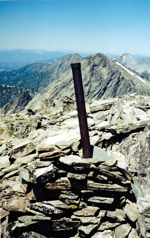
From your entry point onto Monument’s Southwest Ridge (8,350 feet), simply follow the right/southeast side of the ridge crest to stay away from the steep drop-offs on the left side and to hike in open terrain on the Southeast Edge of the forest higher up. Upon reaching tree line, the terrain gets a bit rockier. The ridge turns right/east at 10,000 feet. Scramble up the ridge talus (Class 2+ at worst) to the gentle summit. From the summit, enjoy the amazing panoramic views of Freeman Peak, Freeman Peak South, and the Sacagaweas. Retrace your steps back to the jeep road and your parking spot.
Additional Resources
Regions: Beaverhead Range->EASTERN IDAHO
Mountain Range: Beaverhead Range
Year Climbed: 1978
First Ascent Information:
- Other First Ascent: SW Face via Freeman Peak’s SW Ridge
- Year: 2017
- Season: Summer
- Party: Livingston Douglas
- Other First Ascent: Northwest Face
- Year: 2017
- Season: Summer
- Party: Livingston Douglas