Elevation: 10,255 ft
Prominence: 395
This peak is not in the book. Updated November 2022
Robbery Peak is located at the north end of the Smoky Mountains near the point where the range melds into the Sawtooth Range. USGS Galena
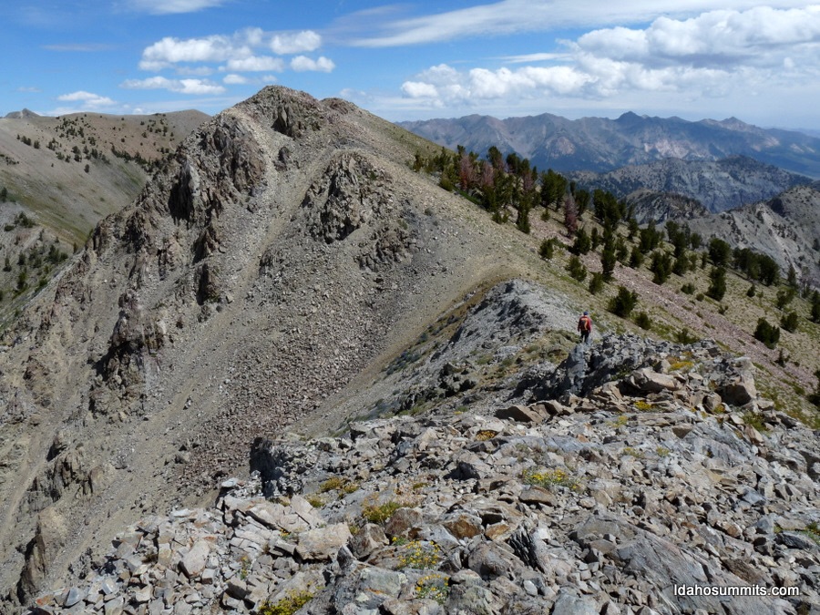
Robbery Peak. Dan Robbins Photo
Access Updates and Map Errors
From ID-75, turn left/south onto [signed] Salmon River Road/FSR-215 and drive 3.1 miles to the road’s end at the Mule Creek Trailhead/FST-198, which is just past the Chemeketan Campground (a group campground by reservation only). The trailhead is a large turnaround with ample parking (7,550 feet). GPS coordinates: 43⁰50’48”N, 114⁰45’09”W. The USGS map shows the Salmon River Road going much farther up the Salmon River Valley than it actually does. The road has been gone for so long that there aren’t even any remnants of it after hiking a short distance from the trailhead. There is only a narrow footpath heading up the Salmon River (FST-198). And, perhaps strangest of all, the trail is called the Mule Creek Trail even though it follows the Salmon River.
Mule Creek is a small creek on the south side of the major east-west ridge crest that separates Blaine County from Camas County, the same ridge crest upon which Robbery Peak is located. You won’t even get close to Mule Creek on this hike.Yes, at 3.3 miles, there is a trail junction where FST-198 heads right/southwest to climb up over the ridge crest then descend a ridge well east of Mule Creek then descends a gully east of Mule Creek to reach the West Fork Big Smoky Creek. FST-198 never follows, or even gets close to, Mule Creek. At the aforementioned trail junction, the main trail becomes FST-072 and heads south up over the major east-west ridge crest to drop into the Big Smoky Creek drainage.
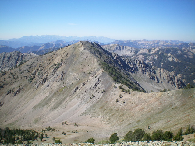
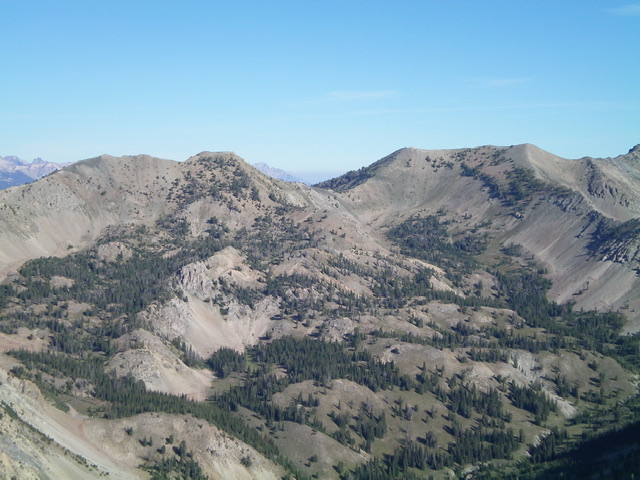
Robbery Peak (mid-ground, left of center) as viewed from Camas County HP to its south-southwest. Livingston Douglas Photo
West Ridge, Class 3
The Climb
Hike 3.3 miles up FST-198/Mule Creek Trail to an unsigned trail junction (broken pieces of a trail sign are laying on the ground). Go left here onto FST-072/Big Smoky Trail and follow it for 0.4 miles as it drops into a meadow and heads southeast to a forested saddle at 8,300 feet. Leave the trail at the saddle and bushwhack northeast then east up through a thick pine forest with lots of large blowdown. The west ridge is not obvious and it is a convoluted mess in this area. Stay in open scrub/gravel as much as possible. This section is very steep and loose. Stay left/north of an impossibly steep, loose area.
The ridge gains definition and the slope eases a little before reaching Point 9034. From Point 9034, descend 85 vertical feet through a thick forest, heading northeast to find a saddle. Scramble up another steep section (600 vertical feet) of semi-open forest up a less well-defined ridge. The scree/gravel here is very steep/loose and the forest is loaded with deadfall. Reach a narrow, rocky ridge crest heading right/southeast about 600 vertical feet below the summit. This rock is firmer and is a joy. Just be careful to not slip on the steep scree/gravel on the sides of the ridge crest. The exposure on the left/north side of this narrow ridge section is deadly. The ridge outcrops and cliff bands go at Class 3.
Battle with ridge firs until about 9,800 feet when they disappear. Scramble up a steep section of very loose scree/gravel to reach the first false summit hump. There is a use trail of sorts in the gravel to help you. Scramble over two more ridge humps (30-foot drop, 60-foot drop) to reach the rocky, ridge crest summit hump of Robbery Peak. The summit had only a modest cairn so I built it up significantly. There is a gentle ridge hump about 75 yards to the northeast which measures of equal height but I believe that the rocky hump (the southwest summit) is the high point by a smidge and IS the high point according to the USGS topo map.
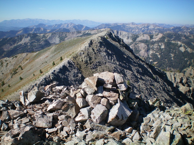
The enhanced summit cairn atop Robbery Peak, looking southwest along the summit ridge (my ascent route). Livingston Douglas Photo
North Ridge, Class 2
The Descent
From the summit, follow the ridge to the northeast summit then descend the shale and rocky outcrops on the north ridge down to a saddle, using a goat trail at times on the left/west side of the ridge crest. The north ridge is in open terrain (see photo) and goes at Class 2, far easier than the west ridge ascent route. The north ridge terminates at the 9,900-foot connecting saddle with Camas County HP. This concludes the first leg of today’s 2-peak journey. Camas County HP is up next.
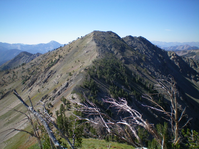
Robbery Peak as viewed from the north. The north ridge (my descent route) is coming at the camera, just left of center. Livingston Douglas Photo
Robbery Peak (left of center) and Camas County HP (right of center, flat-topped) as viewed from Shadow Peak to the south. Livingston Douglas Photo
Additional Resources
Regions: Smoky Mountains->WESTERN IDAHO
Mountain Range: Smoky Mountains
Longitude: -114.72229 Latitude: 43.80749