Elevation: 10,757 ft
Prominence: 297
Climbing and access information for this peak is on Page 267 of the book. Updated November 2021
Metaxy Peak is located between Mount Darcy and Pahsimeroi Pyramid on the main Pahsimeroi Crest. USGS Grouse Creek Mountain
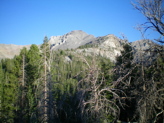
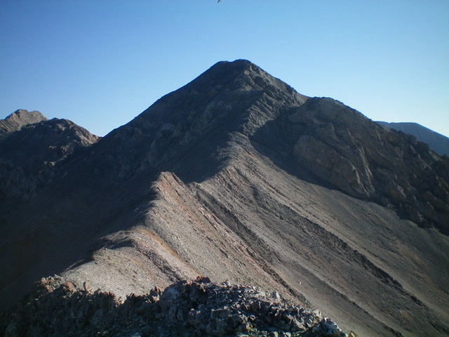
Metaxy Peak (summit is just left of center) and its east ridge (right of center and coming at the camera) as viewed from Christian Gulch. Livingston Douglas Photo
Access
This is the first leg of a 2-peak journey that includes Metaxy Peak and Pahsimeroi Pyramid (10,749 feet). It covers 7.5 miles with 3,650 feet of elevation gain round trip.
Christian Gulch Road/FSR-115 is an unsigned 2-track road that is located along Doublespring Pass Road/FSR-116 exactly 14.4 miles north of US-93 and 3.8 miles north of the signed junction with Horseheaven Pass Road/FSR-117. Reset your odometer at the junction of Christian Gulch Road and Doublespring Pass Road. At 4.0 miles, reach a signed junction. Go straight/west on FSR-409. At 4.4 miles, park at the base of a steep hill where the road gets much rougher (7,980 feet). GPS coordinates: 44⁰18’30”N, 113⁰53’08”W.
East Ridge, Class 3
The Climb
From the parking spot, hike west then northwest up FSR-409 (an old 2-track road) to its end on a semi-open, forested shoulder that shows signs of previous logging activity. Bushwhack southwest up the crest of the shoulder through blowdown and some brush to reach Point 8662. From here, you have good views of Peak 10340 to the north and Point 10676 to the south. Head west from Point 8662 down slightly to a flat area then up a forested slope to a flat spot with great, semi-open views. You can now see the east ridge of Metaxy Peak ahead of you. Establish a general direction here to reach the ridge because you are about to lose visuals in the thick pine forest on your way there.
Descend west about 70 vertical feet to reach the base of the ridge, though it’s not obvious. Climb northwest up the forested, semi-open ridge on rocky terrain to reach tree line higher up. Once above tree line, it is a combination of a scree slog and climb up some rocky ridge outcrops to reach the summit. The best footing is on the ridge crest itself and there are some goat trails to help in ascending the sections of loose scree. The ridge becomes quite steep and loose higher up. You must climb over a minor cliff band (Class 3) high on the ridge. At about 10,000 feet, the ridge bends left/west. The summit of Metaxy Peak is small and bare. It has a small summit cairn. The summit offers a magnificent view of the south ridge and east buttress of Mount Darcy to the north and of the northwest ridge and rugged north face of Pahsimeroi Pyramid to the south.
Metaxy Peak (right of center, mid-ground) as viewed from Pahsimeroi Pyramid. Livingston Douglas Photo
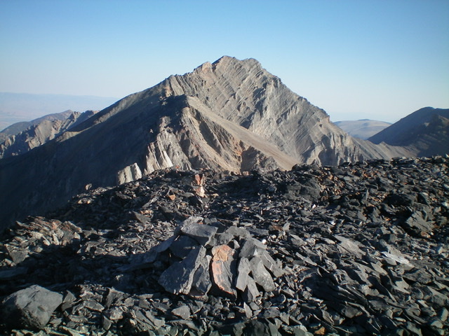
Looking at the summit from high on the east ridge. Livingston Douglas Photo
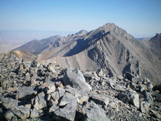
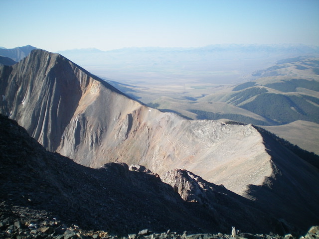
Looking south at Pahsimeroi Pyramid (mid-ground) from the summit of Metaxy Peak. Livingston Douglas Photo
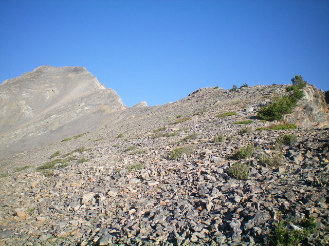
Looking back at the south ridge of Metaxy Peak. The upper section is steep, loose, and crumbly. Livingston Douglas Photo
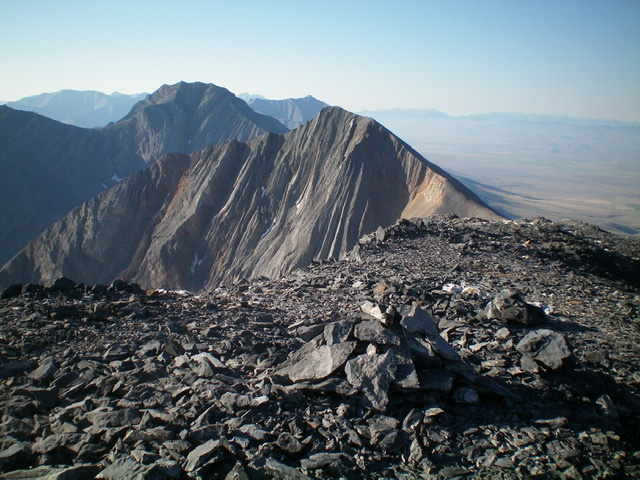
Looking north at Mount Darcy (dead center in distance) from the summit of Metaxy Peak. Livingston Douglas Photo
South Ridge, Class 3
The Descent
From the summit, descend the ridge south through some crumbly pinnacles, most of which can be downclimbed and others can be skirted. The scree chutes on the right/west sides of these pinnacles are wickedly steep and loose, but are your only option to downclimbing the crumbly pinnacles directly. The left/east side of the pinnacles is a death trap. Avoid it.
Find a goat trail lower down on flatter ridge terrain. Work south across an elongated saddle with a few ridge humps to skirt (using the goat trail on the right/west side) but one bigger hump must be climbed (not difficult). Continue southward along the narrow ridge crest to reach the low point, the 10,180-foot connecting saddle with Pahsimeroi Pyramid. This concludes the first leg of today’s 2-peak journey. Pahsimeroi Pyramid is up next.
Descending the curving connecting ridge between Metaxy Peak and Pahsimeroi Pyramid. The northwest ridge of Pahsimeroi Pyramid heads diagonally up and left to reach the summit at the upper left of the photo. Livingston Douglas Photo
Additional Resources
Regions: EASTERN IDAHO->Lost River Range->Pahsimeroi Range
Mountain Range: Lost River Range
Year Climbed: 1991
Longitude: -113.93039 Latitude: 44.30529