Elevation: 11,308 ft
Prominence: 160

This peak is on a spur ridge of Peak 11367/Mount Morrison (Page 274 in the book). This summit is 0.65 miles NNW of the summit of Peak 11367. It is not listed as a separate peak in the book because the connecting ridge does not drop more than 300 feet. Nevertheless, as the route descriptions below demonstrate, this peak offers some excellent technical climbing opportunities. USGS Elkhorn Creek
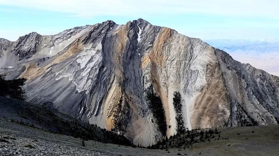
Point 11308. Clint Barg Photo
White Line Couloir III 5.6 WI4
Dean Lords, Jason Gee (1st attempt April 1995)
Dean Lords, Dan Harker (Completed May 1996)
This route is located on the Southwest Face of Point 11308, which sits 2.3 miles southwest of Borah Peak. The Southwest Face is a complex series of towers, gullies, and steep walls of rock. The White Line ascends the leftmost couloir system on the Southwest Face, not to be confused with the obvious rightmost avalanche gully descending down the West Face of the mountain. This is a technical Winter climb that involves moderately-angled snow, water ice, and sections of rock climbing. A Winter with above-average snowfall is most likely required for this ephemeral route to form. Point 11308 is located on the Elkhorn Creek quadrangle and is identified as the peak immediately ENE of Whiskey Springs.
At the left bend in the highway immediately northwest of Whiskey Springs, drive or hike up a steep 4WD road that ends near the lower treeline. This road ascends the West Side of the mountain. From the end of the road, continue hiking along the left side of a fence that trends up and left from the end of the road. After some distance, a steep ravine is encountered. Cross this ravine and continue up and left into the next drainage. Follow this drainage into the bowl (avalanche prone) below the Southwest Face. As seen from the bowl, the right side of the White Line Couloir forms the left edge of an obvious tower.
Ascend snow slopes to the base of the route. An overhang blocks the very start of the couloir. Climb a shallow chimney (sometimes icy) to the left of this overhang for half a rope length (5.6) onto the slopes of the couloir. Climb straightforward snow for several hundred feet up the couloir and pass short sections of 60° ice (or rock slabs depending on conditions) to gain an obvious left bend in the couloir. Two options exist: (1) climb a steep pencil of ice in the back of a chimney on the left side of the couloir (WI-4, M5) onto a slab. Climb this slab for a short distance, then up the continuation of the chimney on ice and rock (M5). Finish the pitch up the steep snow couloir and belay at the right bend in the couloir (60m).
(2) Climb easy ice runnels and slab rock on the right side of the couloir to gain the steep snow above (WI-3, M3/4). The climbing above the right bend stays in a tight chimney for one and a half pitches of rock, ice and snow. These pitches offer enjoyable mixed climbing. The top of the technical portion is marked by a huge chockstone. From this point, descend the steep gully on the opposite side of the ridge to reach the open slopes below the summit. This open slope is the top of the obvious West Face avalanche gully and could be very dangerous in poor conditions.
The descent was made down a steep gully on the Southwest Side of the mountain and is located several hundred yards up the snowfield from the top of the technical portion of the route. Look for an obvious boulder at the top of the gully. Walk down the gully until a steep section is encountered near the bottom, traverse over a small rib on the left side of the gully and continue down into the bowl below the Southwest Face. BIG avalanches are possible in the bowl below the Southwest Face. Choose a safe day to climb.
Regions: EASTERN IDAHO->Lost River Range
Mountain Range: Lost River Range
Longitude: -113.8050 Latitude: 44.1093