Elevation: 8,809 ft
Prominence: 1,199
This peak is not in the book. I included Rick Baugher’s trip report at the end of the page.
Red Mountain is the highest of the Gannett Hills. It is also a relatively short distance from Crow Creek Road to its west. The bushwhack directly east to the summit is not pleasant, particularly the [almost] 300-foot descent to cross Beaver Creek. If you have an ATV or MC (or road conditions permit), you may be able to do a much easier climb via the Baugher route from Crow Creek Summit. Baugher rode a motorcycle to reach that starting point. Crow Creek Road gets rough after Parking Spot #2, described below. USGS Meade Peak
Access
From US-89 east of Montpelier, drive north up [signed] Crow Creek Road/FSR-111 for 9.6 miles to the [signed] Preuss Creek trailhead. It has a jeep road near it (FSR-110) going up Preuss Creek a short distance to two shaded campsites. From the Preuss Creek trailhead turnoff, continue driving up Crow Creek Road for 0.8 miles to a sharp bend in the road (7,280 feet). Park here for the ideal launch point for this climb of Red Mountain. Let’scall it Parking Spot #1.
From Parking Spot #1, walk about 0.1 miles up Crow Creek Road then leave the road to descend right/east to bushwhack across Beaver Creek and begin the climb of the west ridge of Red Mountain. Alternatively, drive another 0.8 miles up Crow Creek Road from Parking Spot #1 (i.e., 1.6 miles up Crow Creek Road from the Preuss Creek trailhead turnoff) to a side road (not shown on maps) in an open area (7,433 feet). Park at this unsigned road junction.
This is Parking Spot #2 and this is where I began my climb of Red Mountain. It was a much more difficult bushwhack than if I had started from Parking Spot #1 (which was the target on my descent route). I learned my lesson the hard way. All of that said, it took just under 1-1/2 hours to complete the ascent and just under an hour to complete the descent. This adventure covers 5.0 miles with 2,050 feet of elevation gain round trip.
West Ridge, Class 2
The Climb
Red Mountain is a behemoth. It particularly stands out when viewed from Crow Creek Road. From Parking Spot #2, bushwhack east and descend 140 vertical feet to cross a dry gulch. Continue east 70 vertical feet up over a minor ridge thendescend southeast for 200 vertical feet to cross Beaver Creek. The sagebrush slope down to Beaver Creek is particularly thick and unpleasant. Beaver Creek is relatively small but is marshy. There are cattle trails and remnants of an old road next to the creek. Bushwhack through some tall willows to find a path across Beaver Creek (not difficult). Once across the creek, you are at the base of the west ridge of Red Mountain.
Once on the east side of Beaver Creek, scramble east up a steep sagebrush slope to get onto the ill-defined west ridge at its toe. Work up through endless, thick sagebrush and some aspens to reach easier terrain and a better-defined ridge higher up. The correct ridge has a gully on its right/south side with a forested ridge just across the gully (the southwest spur). All of these natural features can be easily identified by consulting the USGS topo map of this area. Bushwhack across a flattish section of sagebrush (using cattle trails).
Once across the flat ridge section, climb east up a steep sagebrush hillside (staying just to the right/south of an aspen forest) to reach a rockier ridge section that is narrow and heads right-ish/south. Follow the ridge as it bends left/east then left again (northeast) to reach the gentle hilltop summit area. There is a decent cairn on top. The final upper section of the west ridge is mostly short scrub and easy rock but most of the west ridge climb is in thick sagebrush. Cattle trails help in the mid-section of the west ridge and up the steep slope to reach the narrower, rockier ridge section high on the west ridge.
The Descent
From the summit, descend the west ridge back down to Beaver Creek. Follow the creek downstream (south) briefly to reach the aforementioned gully between the sagebrush hill at the toe of the west ridge and the toe of the southwest spur (the forested hill). Cross to the west side of Beaver Creek here (a minor, wet gully) the climb west up for 150 vertical feet up through the forest to reach Crow Creek Road. Follow Crow Creek Road for 0.7 miles north to return to Parking Spot #2. From a bushwhacking perspective, I must preferred the descent route to the ascent route. The point at which the descent route reaches Crow Creek Road is 0.1 miles north of Parking Spot #1.
Rick Baugher’s Trip Report
Red Mountain (8,809 feet), to the best of my knowledge, is the high point of the Gannett Hills. The summit of the mountain is located in Bear Lake County. On 10/26/01, I drove and rode from Montpelier, ID to the summit of Crow Creek Road (7,481 feet). From here, the hike went east, ascending yet more muddy, trail-less slopes to reach the summit of Red Mountain in the red of sunset light. Great view of Thomas Fork Valley. Saw a herd of 20 elk near the top. Was lucky not to be shot by hoards of hunters in the area.
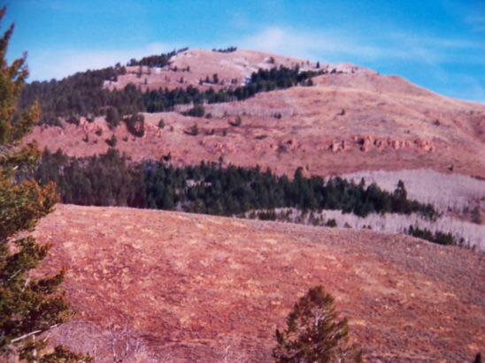
The west aspect of Red Mountain (10/26/01). Rick Baugher Photo
Additional Resources
Regions: Gannett Hills->SOUTHERN IDAHO
Mountain Range: Peale Mountains
Longitude: -111.12669 Latitude: 42.47189