Elevation: 7,826 ft
Prominence: 886
This peak is not in the book. There are two routes below. The first by Rick Baugher and the second by Livingston Douglas which is the more difficult of the two. Updated November 2019
The Sheep Creek Hills HP is located due east of Montpelier. There is an electronics installation on the summit. USGS Montpelier Canyon
Southeast Slopes, Class 2 by Rick Baugher
Access
On 7/15/13, I approached from the southwest by driving east up Bear Hollow Road. This is a well-graded but unsigned County Road crossing private range land. As the road enters the Sheep Creek Hills, it becomes eroded, especially so as the track turns north to gain elevation. I parked around 7,200 feet and hiked north.
Route
After crossing the gate into Caribou National Forest, ascended cross-country up the brushy southeast slope to gain the summit of Sheep Creek Hills HP. At the com towers, chatted with two Rocky Mountain Power techs who had driven their service truck up there. Topic of conversation: watch out for snakes in the area. Rick’s LOJ trip report is also linked below.
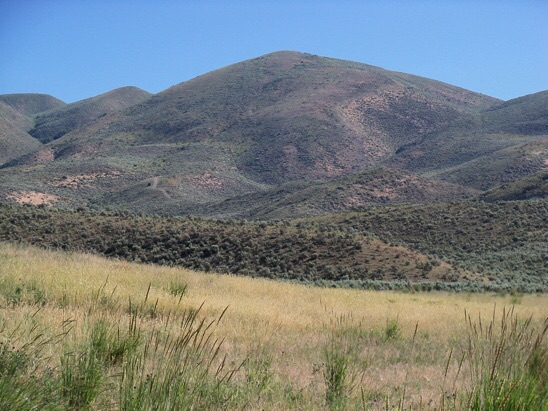
The southwest side of Sheep Creek Hills HP as viewed from Bear Hollow Road. Rick Baugher Photo
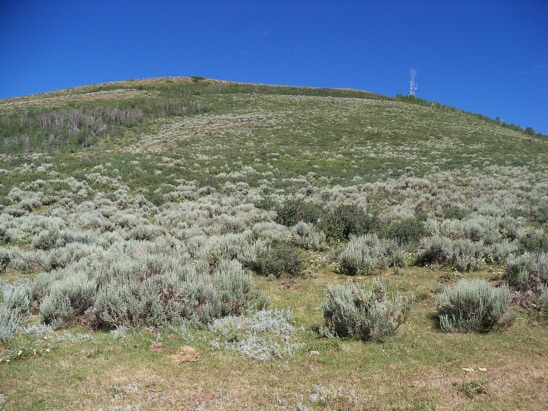
The southeast line of ascent thru the brush and scrub to the com tower summit of Sheep Creek Hills HP (7/15/13). Rick Baugher Photo
North Face/Northwest Ridge, Class 3 by Livingston Douglas
Access
From Montpelier, ID, drive east up US-89 for 3.5 miles to Montpelier Canyon Campground, which is located on the right/south side of the highway. Park either in the campground ($5 day use fee) or park 0.1 mile west on US-89 on a side road. The elevation at this side road is 6,205 feet.
The Climb
This is a very steep, punishing bushwhack in thick forest and brush. I do not recommend it. From the side road, walk 0.1 mile east on US-89 to the entrance to Montpelier Canyon Campground. Walk through the campground to Campsite #10. Only Campsites #9 and #10 are located on the south side of raging Montpelier Creek. You don’t want to start this climb from the north side of Montpelier Creek and have to ford it. Trust me.
This area has a lot of private land to avoid. Look closely at the USGS Montpelier Canyon quadrangle to see the boundary line of the Caribou National Forest. But of equal importance for the launching point for this climb is the fact that there are private homes/ranches just northeast of the Montpelier Canyon Campground in an open meadow. You really have to thread a needle to find your way back to the campground and avoid wandering onto that private land nearby. But it is quite doable.
From Campsite #10, bushwhack straight up through the thick, brushy forest in very steep terrain. There is steep dirt and gravel mixed in to make this climb even more challenging. Find a weak trail that follows a shoulder then bushwhack up a nearby small gully to the right/west. The terrain soon pushes you left/east to a fence row that is about 300 vertical feet above the campground. This fence row is a Godsend. It heads straight up the face to the northwest ridge and has a narrow footpath on its right/west side.
When you pop out on the northwest ridge, you will breathe a great [and well-deserved] sigh of relief. The going is open and MUCH EASIER now. There is some mountain mahogany and scrub to contend with early on but the mountain mahogany disappears as you gain elevation on this ridge. And there are some ridge points requiring ups-and-downs but this sure beats the forest bushwhack coming up the North Face!
Follow the ridge southeast, aiming at a radio tower on Point 7770. The ridge terrain flattens in a sagebrush saddle and you find a decent jeep road there to expedite your ascent to the summit of Sheep Creek Hills HP. Hike up the jeep road as it heads south then east up to a saddle just south of Point 7770. From here, a much better jeep road leads right/south to the summit of Sheep Creek Hills HP. This summit has the most impressive collection of radio/cellphone towers in this area.
The final section of the access road has a marvelous gravel base and weaves its way to the antenna-clad summit. The high point seems to be near the road at a corner of the fenced antenna facility. As is typical on antenna-clad summits, there is no summit cairn to be found here.
The descent back to Montpelier Canyon Campground is a treacherous affair, even along the fence row. The terrain is so steep that you will lose your footing on the forest duff and loose gravel numerous times. You’ll be grabbing at any branch or piece of brush to brake your descent—consequently, I give this route a Class 3 rating. You WILL be using your hands extensively. Good luck finding Campsite #10 in all of the thick forest (which includes brush and impossibly thick aspens). I came out at Campsite #9 on my descent and the descent was a bit thicker and brushier than the ascent but I was just happy to reach the campground and not wander off onto private land.
Additional Resources
Regions: Peale Mountains->Pruess Range->SOUTHERN IDAHO
Mountain Range: Peale Mountains
First Ascent Information:
- Other First Ascent: North Face/Northwest Ridge
- Year: 2019
- Season: Summer
- Party: Livingston Douglas
Longitude: -111.21279 Latitude: 42.31889