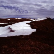
Elevation: 9,577 ft
Prominence: 247

Climbing and access information for this peak is on Page 368 of the book. Livingston Douglas provided the update found below which provides important access information in this age of ATV trails. Updated November 2018
Snowdrift Mountain is located east-northeast of Georgetown, Idaho and directly north of Meade Peak. USGS Snowdrift Mountain

The summit of Snowdrift Mountain (June 1983).
2018 Update by Livingston Douglas
North Ridge, Class 2
Access
From the signed turnoff on US-30 in the center of the bustling metropolis of Georgetown, ID, turn east onto Georgetown Canyon Road (which is called Stringtown Road within the city limits). Drive up the road to a junction at 2.3 miles (LEFT is CR-1095/Left Hand Fork Road; STRAIGHT is Georgetown Canyon Road/FSR-102). Go straight; the road changes from paved to gravel here. At 3.5 miles, you enter the Caribou National Forest. At 11.7 miles, the road crests at Georgetown Saddle and enters Caribou County. Park at this saddle at the junction with FSR-342 to the left/west. The elevation here is 8,050 feet.
The Climb
From the junction of FSR-102 and FSR-342 at Georgetown Saddle, hike southeast up an unmarked ATV trail for about ¾ mile to a signed ATV trail junction at about 8,300 feet. The unmarked ATV trail ends here at this “T” junction. There is a damaged, unreadable NFS sign for the northbound ATV trail; there is no sign for the southbound ATV trail. On the NFS map, this is a trail with no NFS number. The northbound ATV trail descends to Trapper Cabin. The southbound ATV trail descends through the broken rock/gravel of the old phosphate mining area and eventually turns right/west to reach Georgetown Canyon Road. Neither trail ascends to the north ridge of Snowdrift Mountain. A separate trail is shown on the NFS map and ascends eastward to the north ridge of Snowdrift Mountain. Unfortunately, this trail no longer exists. You must bushwhack east up the steep, forested slope to reach the north ridge. The “Snowdrift Mountain Trail” commentary on Page 369 of the book is outdated in this respect.
From the trail junction, follow the ATV trail left/north (briefly) for a better starting point to begin the bushwhack east up to the north ridge. Leave the trail and climb up through the moderately-dense forest for about ½ mile to reach the north ridge. This bushwhack requires about 400 feet of vertical gain. On the east side of the ridge crest, you will find the ATV trail/old jeep road (FST-561 on the NFS map) that follows the north ridge all the way to the summit. The entry point onto the ATV trail is near a minor saddle. Make a good mental note of this saddle because on your return, you must leave the trail here to descend back down to the trail junction and the spur trail that led to there from Georgetown Saddle.
FST-561 is an old jeep road (now an ATV trail) that stays on the leeward left/east side of the ridge crest for the first mile or so. For the remainder of the journey, the trail is almost always on the windward right/west side of the ridge crest. There are many ups and downs as you progress southward on FST-561 (570 feet of extra uphill roundtrip). This is in addition to the 260 feet of extra uphill (roundtrip) on the spur ATV trail that got you from Georgetown Saddle up to the “T” trail junction on the west side of the mountain.
As you plod southward on the north ridge, you will see a much higher peak in the distance. That peak is Meade Peak (9,957 feet). You are not going that far. You are going to stop well short of Meade Peak, on a point that is called Snowdrift Mountain. It is NOT a ranked summit. There are multiple points on this LONG ridge (about 3-1/8 miles from the ridge entry saddle to the summit) to confuse you. Most of them aren’t high enough in elevation to warrant a closer look. But the final false summit/point is Point 9559, a rocky outcrop that is VERY CLOSE in height to the true summit (9,577 feet) about 0.3-0.4 miles to its south.
The true summit of Snowdrift Mountain is a ridgeline summit covered with veg and short bushes. This is in stark contrast to the very rocky outcrop that is Point 9559. When you stand on the true summit and look northward, you can see the full extent of the rocky protrusion that is Point 9559. It is impressive. There was nothing on top of the true summit. The views from the north ridge and the summit, particularly when looking eastward, are amazing.
FST-561 doesn’t show much signs of ATV usage. In fact, it is becoming quite overgrown with veg in spots. Old, large cairns mark the route in a few spots, but even the cairns are becoming overgrown with veg! Near the false summit (I believe just north of it on the west side of the ridge crest), there were two sets of five connected, rectangular cisterns full of water. That was unusual. The north ridge is a very open, high ridge crest. Don’t be hiking up here on a windy day or if thunderstorms are in the area.
Additional Resources