Elevation: 10,365 ft
Prominence: 325
Climbing and access information for this peak is on Page 322 of the book. As of 2001, the peak is now officially named Sacajawea Peaks, East.
Rick Baugher made the first recorded ascent of this peak in 1998. He named it South Doublet. South Doublet and North Doublet are perhaps the most impressive peaks in the range. I like Rick’s names because they are unique. However, the new, official names are now the law of the land. Check out the North Doublet/Sacajawea Peaks, West page. USGS Bohannon Spring
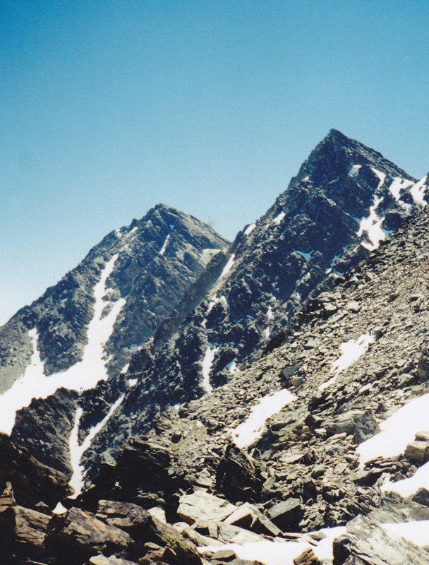
South Doublet and North Doublet Peaks as viewed from the Monument Peak/North Doublet col. Rick Baugher Photo
West Ridge/West Face Route, Class 3 by Livingston Douglas
Access
This climb is part of a ridge traverse between North Doublet and South Doublet. Ascend North Doublet first, then descend to the connecting saddle between North Doublet and South Doublet. Please refer to the route descriptions for North Doublet’s Southwest Face/Northwest Ridge Route and East Ridge Route for more detailed information.
The Climb
From the North Doublet/South Doublet ridge saddle (10,020 feet), scramble eastward up the West Face then West Ridge of South Doublet. The terrain is easy Class 3 slabs, ledges, and boulders. On the West Ridge, you will find a climber’s trail and goat beds. Stay on the north side of the West Ridge to avoid any ridge difficulties. This is more of a face climb than a ridge climb as the ridge is ill-defined.
The summit of South Doublet has nice views of several lakes on the Montana side (Upper Miner Lakes, Hamby Lake, Lake Geneva) as well as an unnamed lake SE of the summit on the Idaho side. The summit has an excellent view of the East Ridge of North Doublet and the Class 3+/4 chute just S of the ridge crest which can be climbed to return to North Doublet’s summit. The West Ridge of South Doublet is a short endeavor: about 10 minutes to ascend and about 7 minutes to descend.
Additional Resources
Regions: Beaverhead Range->EASTERN IDAHO
Mountain Range: Beaverhead Range
First Ascent Information:
- First Ascent Year: 1998
- Season: Summer
- Route: North Ridge
- Party: Rick Baugher
Longitude: -113.67449 Latitude: 45.24939