Elevation: 6,424 ft
Prominence: 881
This peak is not in the book.
Sunset Peak is located west of the Idaho/Montana border between Canyon Creek to the south and Pritchard Creek to the north. The area between these two drainages saw extensive mineral exploration and logging operations. As a result, this area is penetrated by many roads. You can drive to the summit. The Forest Service has provided a hiking alternative that is set out below. USGS Burke
Access
The Forest Service lists two sets of directions. The first is for the hiking route to the peak. The second is for driving to the peak.
Lower Trailhead. From Coeur d’Alene, drive east on I-90 for approximately 50.0 miles. Take the West Wallace Exit (Exit 61). Travel 13.1 miles north on FS-456 over Dobson Pass to Delta Junction. Turn right and travel 3.0 miles up FS-605 to Kings Pass. At Kings Pass, turn right onto an old mining road and travel 1.5 miles to the lower trailhead.
Sunset Peak Summit. Follow same directions as for Access #1 except turn right at the top of Dobson Pass and follow signs to Sunset Peak. The upper trailhead is located at the top of Sunset Peak down a rocky road. Please note that this access road is on private property and access may be restricted at any time.
Northwest Ridge, Class 1
Climb this peak in conjunction with a climb of Pony Peak via FST-151. This trail mostly follows a ridge line. The Forest Service write-up for this trail states: “You will pass through a timbered area until you reach Pony Peak and then follow a long, grassy ridge that offers a beautiful panoramic view of the area below. Sunset Peak is the site of an old abandoned lookout on top of a rocky ridge. No water is available along this trail.” It is a 6.5-mile one-way hike to the summit with an elevation gain of nearly 3,000 feet. The trail is open to motorcycles.
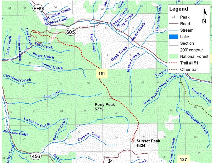
Forest Service Map of the Sunset Peak hiking route. This map does not show the road to the top of the peak.
Additional Resources
Regions: Coeur d'Alene Mountains->NORTHERN IDAHO
Mountain Range: Coeur d'Alene Mountains
Longitude: -115.8344 Latitude: 47.5635