Peak 5021 by Livingston Douglas

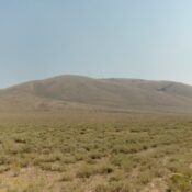
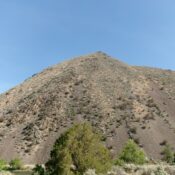
This peak is not in the book. Published October 2025 Peak 5021 is located along US-93 and the Salmon River. It sits above a sharp bend in the highway and several ranches on the east side of the highway. Peak 5021 is a western foothill of Goldbug Ridge. USGS Goldbug Ridge Access Park in a pullout along the Salmon River … Continue reading

Peak 7669 by Livingston Douglas

This peak is not in the book. Elevation and prominence figures are based on recent LiDAR measurements. The USGS quad shows an elevation of 7,663 feet. Published October 2025 Peak 7669 is a Lemhi foothill that sits due east of Summit Reservoir. The northwest summit hump is the high point. Peak 7669 is most easily climbed from the Little Lost … Continue reading

Peak 7362 by Livingston Douglas

This peak is not in the book. This peak is on private property and is not open to the public. Published October 2025 Peak 7362 is located on the west side of Blackfoot Reservoir Road, several miles south of Bone and several miles north of Cranes Flat Road. It is on posted, private ranch land and is closed to the … Continue reading

Peak 7185 by Livingston Douglas

This peak is not in the book. This peak is on private property and is not open to the public. Published October 2025 Peak 7185 is located on the west side of Blackfoot Reservoir Road, several miles south of Bone and several miles north of Cranes Flat Road. It is on posted, private ranch land and is closed to the … Continue reading

Rothorn Spire

Climbing and access information for this peak is on Page 167 of the book. Published October 2025 This peak is located on the main Sawtooth crest between Ed-Da-How Spire and Braxon Peak. The first ascent route is discussed in the book. USGS Warbonnet Peak Kaden Platt Photos and Commentary       … Continue reading

Peak 7966 by Livingston Douglas

This peak is not in the book. Published October 2025 Peak 7966 separates Russell Creek from Dry Gulch in the thickly-forested foothills of the northern Caribou Mountains. Palisades Reservoir is to its southeast. Peak 7966 is most easily climbed from either the Russell Creek Trail or from nearby Bear Creek Road. A difficult bushwhack is inevitable. USGS Red Ridge Access … Continue reading