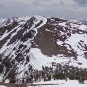
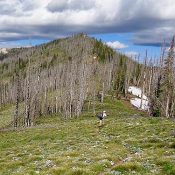
Split Creek Point

The summit cabin is probably tje best built cabin in Idaho. Despite years of neglect it is still standing strong with straight lines and a functioning roof.

This peak is not in the book. Published June 2016 Split Creek Point was once the home of a 75-foot tall lookout tower. Its summit is still graced by a cabin built in the 1930s. The peak stands east of the main Lick Creek Range Crest and west of the Secesh River which cuts a deep canyon along its flank. … Continue reading

Peak 3793

This peak is not in the book. Peak 3793 has the distinction of being the steepest peak in Ada County. This peak is located just west of the Bogus Basin Road. USGS Boise North Access Park on the left side of Bogus Basin Road, 4.2 miles from Hill Road at an elevation of roughly 3,440 feet. There is a large … Continue reading

Peak 9345 (Frenchman Peak)

This peak and North Frenchman Peak (which is also discussed herein) are not in the book. Dave Pahlas and John Platt provided the information for the winter ascent of both peaks which is set out below. Livingston Douglas authored the Livingston Douglas North Ridge/South Ridge Traverse entry below. Updated November 2022 Frenchman Peak and North Frenchman Peak (9,139 feet) are located … Continue reading

Peak 8762 (Bull Horn Mountain)

This peak is not in the book. Bull Horn Mountain is located northeast of Bull Trout Point and due east of ID-21 and the northernmost Sawtooth peak, Copper Mountain. It is relatively quick ascent from the highway. Park in the large pullout on the west side of ID-21 at Newman Creek in the Summer or at the point where the … Continue reading

Peak 9583

This peak is not in the book. Peak 9583 sits just northeast of the Finger of Fate. It has a rocky, exposed summit. The only persons to my knowledge who have climbed it are John Fadgen and Dave Pahlas. See the links below.  USGS Mount Cramer   … Continue reading

Peak 9980 (East Chamberlain Peak)

This peak is not in the book. Dave Pahlas climbed this peak during his traverse of the long ridge that separates Germania Creek from Chamberlain Basin. His trip took him to the summits of West Chamberlain Peak, Jack Chamberlain Peak and East Chamberlain Peak. See his trip report for details. USGS Boulder Chain Lakes   … Continue reading