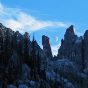
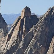
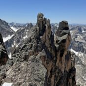
Peak 6987 by Livingston Douglas

This peak is not in the book. Rick Baugher proposed the name South Taurus. Published October 2025 Peak 6987 is the high point on a lengthy ridgeline that sits just east of the South Fork of Bull Canyon in the Deep Creek Mountains. It is most easily climbed from nearby South Bull Canyon Road. This area is a mix of … Continue reading

Peak 6203 by Livingston Douglas

This peak is not in the book. Published October 2025 Peak 6203 sits above the convergence of the Bull Canyon and South Fork drainages in the foothills of the Deep Creek Mountains. This area is a mix of private and public land, so be careful. This climb is entirely on BLM land. USGS Cedarhill Access From Arbon Valley Road, turn … Continue reading

Peak 9980

This peak is not in the book. Percoski and Platt found evidence of a prior ascent but nothing to date the earlier climb. So far, a search of the literature has not found a reference to this peak nor a name. This is surprising as nearly every other technically difficult summit in this area was climbed and named by the … Continue reading

Peak 6760 by Livingston Douglas

This peak is not in the book. The elevation and prominence figures are based on recent LiDAR updates. The USGS quad shows an elevation of 6,763 feet. Published October 2025 Peak 6760 is a foothill of the Pleasantview Hills that has communication towers on its northeast summit. The southwest summit hump is the high point. The only public access is … Continue reading

Peak 7220 by Livingston Douglas

This peak is not in the book. Published October 2025 Peak 7220 sits at the head of both Morgan Jones Canyon and West Elkhorn Canyon in the Pleasantview Hills. It is most easily reached from West Elkhorn Canyon Road to its south. This climb is entirely on public land. USGS Sheep Creek Spring Access Same as for Peak 6397. West … Continue reading