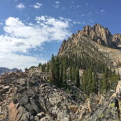
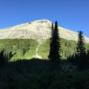
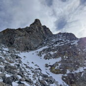
Peak 6760 by Livingston Douglas

This peak is not in the book. The elevation and prominence figures are based on recent LiDAR updates. The USGS quad shows an elevation of 6,763 feet. Published October 2025 Peak 6760 is a foothill of the Pleasantview Hills that has communication towers on its northeast summit. The southwest summit hump is the high point. The only public access is … Continue reading

Peak 7220 by Livingston Douglas

This peak is not in the book. Published October 2025 Peak 7220 sits at the head of both Morgan Jones Canyon and West Elkhorn Canyon in the Pleasantview Hills. It is most easily reached from West Elkhorn Canyon Road to its south. This climb is entirely on public land. USGS Sheep Creek Spring Access Same as for Peak 6397. West … Continue reading

Peak 6397 by Livingston Douglas

This peak is not in the book. Published October 2025 Peak 6397 is a western foothill in the Pleasantview Hills of southern Idaho. It sits east of Arbon Valley Road. This area is a mix of private and public land, so be careful. This climb is entirely on public land. USGS Buist Access From the signed junction of ID-38 and … Continue reading

Peak 5874 by Livingston Douglas

This peak is not in the book. I recommend securing permission from the landowner before climbing this peak. Published October 2025 Peak 5874 sits above the convergence of the Little Malad River and West Elkhorn Canyon in the Pleasantview Hills. This area is a mix of private and public land, so be careful. The summit is on unposted private land. … Continue reading

Peak 6850 by Livingston Douglas

This peak is not in the book. Published October 2025 Peak 6850 is the high point on a ridge that separates Point Canyon from West Elkhorn Canyon in the Pleasantview Hills. It is most easily climbed from the West Elkhorn Canyon BLM Road. USGS Daniels Access Same as for Peak 6542. This is the second leg of a 2-peak adventure … Continue reading