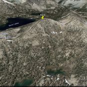
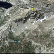
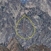
Peak 10383 (Fallshead Peak)

Climbing and access information for this peak is on Page 300 of the book. The suggested name is from Rick Baugher. The access in the book will get you to the peak but the access listed below is a better choice. Fallshead Peak is one of two peaks on the Patterson Divide. This Divide is discussed on Pages 300-301 of … Continue reading

Peak 10300

This peak is not in the book. Peak 10300 is the northernmost 10,000-foot peak on the Patterson Divide. The Divide is discussed on Pages 300-301 of the book. USGS Patterson Access FST-072 [(C)(3)(a) on Page 317] … Continue reading

Patterson Peak Revised by Livingston Douglas

Climbing and access information for this peak is on Page 300 of the book. The elevation and prominence figures are based on recent LiDAR updates. The USGS quad shows an elevation of 10,602 feet. Updated October 2025 Patterson Peak is the high point on a ridgeline located just east of Patterson Creek in the northern Lemhis. It sits just north … Continue reading

Peak 10482 by Livingston Douglas

This peak is not in the book. Updated October 2025 Peak 10482 is located just over ½ mile north-northwest of Patterson Peak in the northern Lemhis. It can be climbed in combination with nearby Patterson Peak or directly from the Patterson Creek Trail to its east. USGS Yellow Peak Access Same as for Patterson Peak. This is the second leg … Continue reading

Peak 10076

This peak is not in the book. Livingston Douglas added new ascent and descent routes as well as new photos. The elevation and prominence figures reflect recent LiDAR updates on Peakbagger.com. The USGS quad shows the elevation as 10,077 feet. Updated October 2025 Peak 10076 is located just south of Everson Lake and east of the main Lemhi Range Crest. … Continue reading