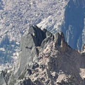
Peak 6990

This peak is not in the book. Elevation is based on recent LiDAR measurements. The USGS Quad shows an elevation of 6985. Published October 2025 Peak 6990 is one of many granite spires found on ridges above the Middle Fork Payette River. It is located north northeast of the Silver Creek Fire Lookout. It sits at the top of the … Continue reading

Peak 10271 by Livingston Douglas

This peak is not in the book. Elevation is based on recent LiDAR measurements. The USGS Quad shows an elevation of 10274. Published October 2025 Peak 10271 is an unranked, rocky peak located on the high ridge that connects Rainbow Mountain (10,163 feet) to Mount Perspiration (10,698 feet). It is most easily climbed from Coal Kiln Canyon to its northeast. … Continue reading

Meadow Creek Mountain by Livingston Douglas

This peak is not in the book. Published October 2025 Meadow Creek Mountain is located east of Wilson Flat on Wilson Ridge. It sits due east of the northern tip of the Blackfoot Reservoir. Meadow Creek Mountain is on posted/fenced, private ranch land and is closed to the public. This post is for informational purposes only. USGS Meadow Creek Mountain … Continue reading

Dam Benchmark by Livingston Douglas

This peak is not in the book. The elevation and prominence figures are based on recent LiDAR updates as found on Peakbagger.com. The USGS quad shows an elevation of 6,931 feet. Published October 2025 Dam Benchmark is located on a high ridgeline due west of the north end of the Blackfoot Reservoir. It is on posted, private ranch land and … Continue reading

Peak 6453 by Livingston Douglas

This peak is not in the book. The elevation and prominence figures are based on recent LiDAR updates as found on Peakbagger.com. The USGS quad shows an elevation of 6,430 feet. Published October 2025 Peak 6453 is a minor forest/scrub hump that sits southwest of the Blackfoot River in the northern section of the Chesterfield Range. It is most easily … Continue reading

Peak 6482 by Livingston Douglas

This peak is not in the book. Published October 2025 Peak 6482 is a scrub hump that separates the Right Fork East Fork drainage from the Left Fork East Fork drainage in the foothills of the Deep Creek Mountains east of Rockland. It is most easily climbed from a gully on its south side and the Right Fork East Fork … Continue reading