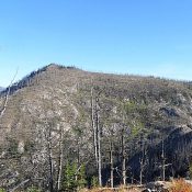
Peak 7544

This peak is not in the book. Peak 7544 sits northwest of Twin Lakes near the Idaho County/Ravalli County border in the Bitterroot National Forest. Wahoo Pass is located on the peak’s South Ridge and Lost Horse Pass is on its East Ridge. The peak is accessed via Lost Horse Road from US-93 south of Hamilton, Montana. This good gravel … Continue reading

Sheephorn Mountain

This peak is not in the book. Livingston Douglas added a new access point, new climbing route, and new photos. Updated October 2025 I ignored Sheephorn Mountain when I wrote the book because it has a road to the summit. Big mistake! This is an impressive peak with great views. The peak is located on the Eastern Edge of the … Continue reading

Peak 8256

This peak is not in the book. Peak 8256 is located on the border of Idaho County and Valley County in the Payette National Forest, just west of Goose Creek/Hazard Lake Road [(B)(1) on Page 134]. The peak lies on a long ridgeline anchored by Slab Butte to the south and Ladybug Peak to the north. Use the link to … Continue reading

Eightmile Mountain by Collin Ciarlo

This peak is not in the book. Eightmile Mountain is located northwest of the South Fork Payette River, West Spring Creek, and Warm Springs Campground. It is a moderate hike at 4.5 miles (one way) and 3500+ feet of elevation gain. The trailhead is on the East Side of the Warm Spring landing strip, just off ID-21. To get to … Continue reading

Peak 8708 (Thirtythree Peak)

This peak is not in the book. Peak 8708 is located in the Lick Creek Range of the Payette National Forest. John Platt has been exploring this rugged and seldom-climbed area and provides an excellent route description. Use the link to his website for details. John’s route is Class 3. He states that there may be a possible Class 2 … Continue reading