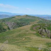
This peak is not in the book. Published November 2019 Peak 6140 is located on the north side of McKim Creek. The only route entirely on BLM land is via McKim Creek Road and the east face. The east face is easily accessed from McKim Creek Road just below a saddle at the base of the face. The southwest ridge … Continue reading
Book Updates
This peak is not in the book. Published November 2019 Peak 6570 is on BLM land. However, it is surrounded by private land on both its north side (McKim Creek) and its south side (Allison Creek). But there is a way to thread this needle and get to the top without ever touching private land. That way is the northwest … Continue reading
This peak is not in the book. Published November 2019 Peak 6033 towers above US-93 and the Salmon River between Warm Springs Road and Poison Creek Road. The only public access is from the north (Warm Springs Road). Peak 6033 is merely a ridge bump (albeit a ranked one) on the long west ridge of Poison Peak. It is a … Continue reading
This peak is not in the book. Published November 2019 Peak 5941 is [barely] a ranked summit that is positioned at the west end of the long west ridge of Sal Mountain. It is located just below, and to the northwest of, Ten Mile Benchmark, an unranked ridge bump. Peak 5941 offers a beautiful aerial view of the twisting Salmon … Continue reading
This peak is not in the book. Published November 2019 Peak 6292 is one of three ranked summits located on a ridgeline that runs west-to-east from Blackrock Canyon to Sawmill Creek Canyon. Peak 6292 is at the head of Caddy Canyon and has a trail all the way to the summit. The BLM Chinese Peak—Blackrock Trail System Map shows all of … Continue reading
This peak is not in the book. Published November 2019 Peak 6359 is one of three ranked summits that sits on a ridgeline that runs west-to-east from Blackrock Canyon to Sawmill Creek Canyon. Peak 6359 is at the head of Blackrock Canyon and has a trail all the way to the summit. The USGS topo map fails to show this … Continue reading