Elevation: 9,248 ft
Prominence: 508

This peak is not in the book. Livingston Douglas added new route, access starting point, and photos. Updated November 2024
This peak is the southwestern-most ranked peak in the Donkey Hills. USGS Short Creek
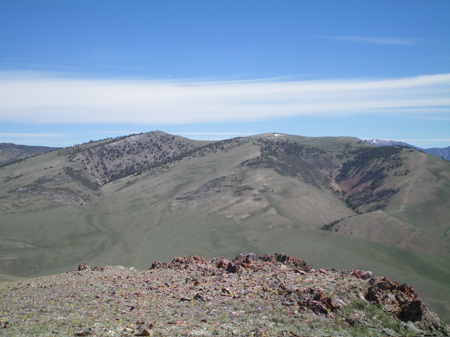
Peak 9248 as viewed from the northeast
Access
The best access to the southern Donkey Hills is from the Dry Creek Road [(A)(6.1) on Page 290]. Follow the Dry Creek Road west to its junction with the Burnt Creek/Long Creek Road (partially signed in 2020). Turn north onto the Burnt Creek/Long Creek, cross Dry Creek and almost immediately turn right/east onto a 2-track road. Follow the 2-track east to a junction with a 4WD road/ATV track that climbs up the unnamed drainage that descends from the Donkey Hills crest to Dry Creek. See map below. This road is one of the most difficult routes to drive in the area. The higher you drive, the more difficult the terrain. Full- sized 4WDs will find it too narrow in spots. This route covers 5.0 miles and gains 1,700 feet in elevation.
North Ridge, Class 2
From the road’s end on the saddle, hike west to the base of the north ridge. Proceed up the ridge to tree line. At this point, a wide game trail is visible. Follow the game trail up and across the peak’s eastern slopes. Once past the trees, turn west and climb to peak’s large, dome-shaped, bald summit.
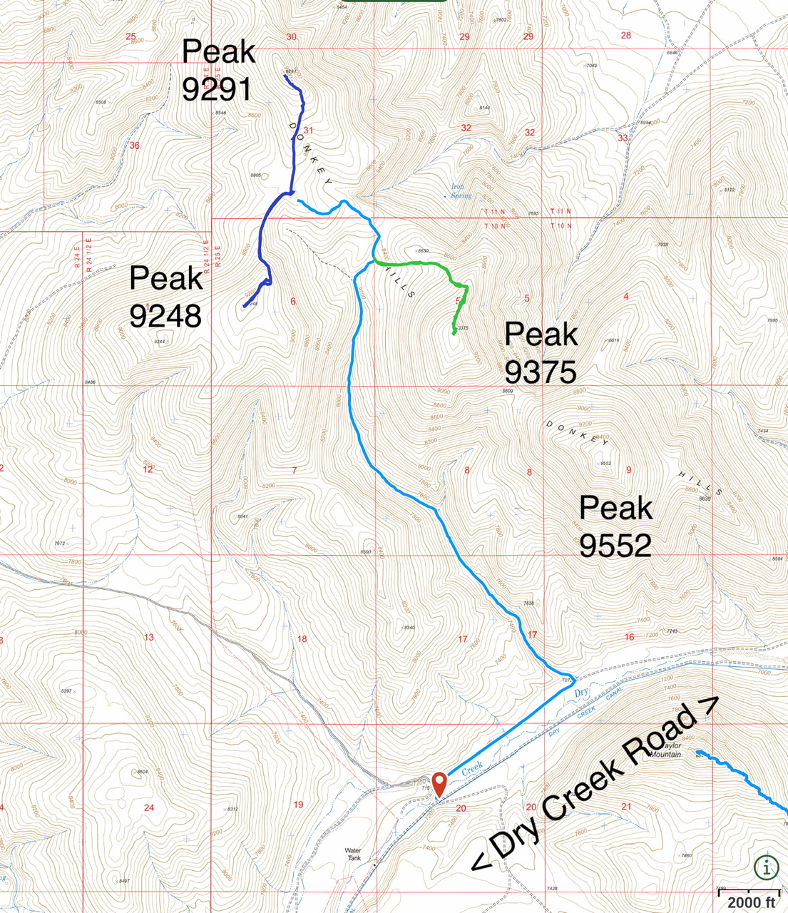
Southern Donkey Hills access. The 4WD road is shown in light blue.
South Ridge and Ridge Traverse to Peak 9291 by Livingston Douglas
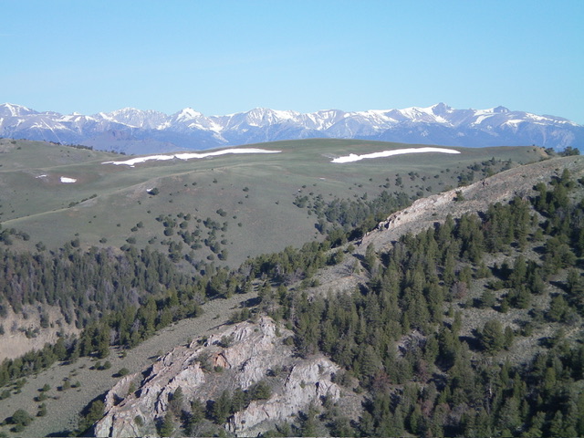
Peak 9248 (dead center) as viewed from the southwest. Livingston Douglas Photo
Access
This access is on far better roads than the Lopez Access for Peak 9248. Given the very difficult (if not impossible) driving situation on the Lopez Access, this access is the shortest route to the top of Peak 9248 from drivable roads. Refer to the Access Section for Peak 9375 to reach the [signed] junction of Lower Dry Creek Road and Long Creek Road. Please note that Lopez refers to Lower Dry Creek Road as “Dry Creek Road.”
From that road junction, drive 2.3 miles northwest on Long Creek Road (a decent, maintained 2-track road) to a high saddle and a large parking area (7,700 feet and 44⁰12’05”N, 113⁰32’44”W). This is the first leg of a 2-peak adventure that includes Peak 9248 and Peak 9291. It covers 7.5 miles with 2,625 feet of elevation gain round trip.
South Ridge, Class 2
The Climb
From the road saddle, hike north up an unmapped 2-track road on the left/west side of the south ridge. The road bends right/northeast and climbs steeply to approach the crest of the south ridge. The road ends here. Scramble northeast up the right/east side of a pine forest that reaches the crest of the south ridge. The terrain opens up here and remnants of an old 2-track appear. Follow the faint remnants of the old 2-track ridge road to the bare summit of Peak 9248.
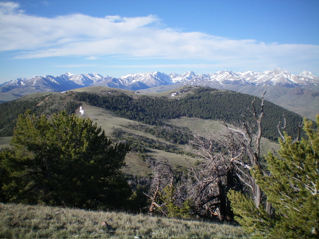
Peak 9248 (in mid-ground) as viewed from the southeast. Livingston Douglas Photo
Peak 9248 (in mid-ground) and its dual summits. The left hump is the true summit. The right hump is Point 9244, only four feet lower in elevation. Livingston Douglas Photo
Ridge Traverse to Peak 9291, Class 2
Descend the north ridge of Peak 9248 to reach a broad, open saddle. Then continue northeast then north up the south ridge of Peak 9291 to its summit. The terrain is a mix of old 2-track roads, easy scrub, and patches of forest. Refer to the Lopez route descriptions for Peak 9248 and Peak 9291 for more details.
Additional Resources
Regions: Donkey Hills->EASTERN IDAHO->Lost River Range
Mountain Range: Lost River Range
Year Climbed: 2020
Longitude: -113.53279 Latitude: 44.22579