This peak is not in the book. Published November 2019 Peak 7826 is located on a ridgeline that comes up from Birch Creek Road to the east. It is one of two ranked summits on this ridge. Both Peak 7826 and its western neighbor (Peak 7848) tower over North Worm Creek Basin to the south. The easiest ascent route is … Continue reading
Book Updates
This peak is not in the book. The proposed name honoring a USGS surveyor was suggested by Rick Baugher. Published November 2019 Peak 7951 is the highest of three ranked summits surrounding South Worm Creek Basin. Unlike the other two peaks, this peak is a rocky one with sheer cliffs on its southeast face. Peak 7951 has a magnificent, challenging … Continue reading
This peak is not in the peak. Published November 2019 Peak 7307 is one of three ranked summits surrounding South Worm Creek Basin. This peak is on the west side of the basin and is the easiest of the three peaks to climb. Cattle trails will get you to the saddle between it and Point 7136 to the northeast. The … Continue reading
This peak is not in the book. Published November 2019 Peak 7462 is one of three ranked summits surrounding South Worm Creek Basin. This peak towers over Rocky Bench to the south. The easiest ascent route is up the south spur/southwest ridge (or the wide gully to its right/northeast) from Cub River Road near the Cub River Guard Station. It … Continue reading
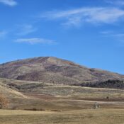
This peak is not in the book. Published November 2019 Peak 6710 is a massive hump located above Worm Creek. It is positioned on the southwest end of a ridge that begins at the high peaks surrounding North Worm Creek Basin and South Worm Creek Basin. The summit is just outside the bounds of the Cache National Forest. However, the … Continue reading
This peak is not in the book. Published November 2019 Peak 7923 is a hidden ridge bump that barely qualifies at a ranked summit. It sits on the west ridge of massive Andrew Nyman Mountain, the high point of which is Wilderness Peak (9,460 feet). It towers over the Maple Creek drainage to the north. The summit ridge is a … Continue reading