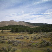
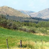
Camelback Mountain

This attractive Pocatello Range peak is not in the book. Access is the main problem confronting climbers. Thanks to Livingston Douglas and the Pocatello BLM office, we now have a clarification and verified access point. Updated November 2019 Camelback Mountain sits due east of Pocatello and north of Chinese Peak in the appropriately-named Pocatello Range. From Pocatello’s west bench, the … Continue reading

Peak 6180

This peak is not in the book. Peak 6180 is located southeast of Pocatello and east of I-15 at the southern end of the Pocatello Range. Rapid Creek is located along the east and north sides of the peak; Sorrelle Canyon lies on the west side. Peak 5932 is located just west of Peak 6180. Peak 6180 is almost entirely … Continue reading

Peak 6361

This peak is not in the book. Livingston Douglas provides more detailed access and information as well as photos. Updated November 2020 Peak 6361 and its popular Pocatello Mountain Range neighbor, Chinese Peak, rise up over east Pocatello and can be reached by various routes that cross over its summit. The two most popular are the ATV track that links … Continue reading

Mount Moh

This peak is not in the book. Livingston Douglas provided an access update and additional photos. Updated November 2023 Mount Moh is located south of Lava Hot Springs, Idaho in the Portneuf Range, which is capped by Sedgwick Peak. Mount Moh has a long north-south trending summit ridge with an electronics facility to the north. Its highest point is found on … Continue reading

Baldy Mountain

This peak is not in the book. Livingston Douglas added a new access point and approach route, a new descent route, new photos, and additional text to the peak description. Updated November 2024 Baldy Mountain sits two miles northwest of Sedgwick Peak. It is a ranked hump on the northwest ridge of Sedgwick Peak. It sits above the headwaters of East … Continue reading

Grass Mountains

The Grass Mountains are located northeast of New Meadows and east of US-93 in the Payette National Forest. The Goose Creek/Hazard Lake Road parallels the east side of this subrange. This convoluted divide trends from north-to-south for roughly 16 miles and encompasses several mountain lakes and bald ridgelines that offer scenic vistas and good hiking. In the book, I included Granite … Continue reading