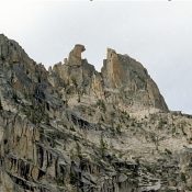
Climbing and access information for this tower is on Page 192 of the book. To read more about the history of El Pima, see Ray Brooks’ article: Fred, Pete and Jack’s Big Sawtooth Adventure. USGS Warbonnet Peak … Continue reading
Climbing and access information for this tower is on Page 192 of the book. To read more about the history of El Pima, see Ray Brooks’ article: Fred, Pete and Jack’s Big Sawtooth Adventure. USGS Warbonnet Peak … Continue reading
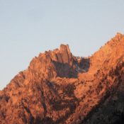
Climbing and access information for this formation is on Page 175 of the book. To read more about the history of Grand Aiguille, see Ray Brooks’ article: Fred, Pete and Jack’s Big Sawtooth Adventure. USGS Mount Cramer … Continue reading
This peak is not in the book. Published December 2019 Peak 6145 is the southernmost ranked summit in the Pioneer Mountains. It is located northeast of Picabo, ID and is rarely visited. Peak 6145 has a lot of private land around it so be careful. Consult the BLM Fairfield map to stay out of trouble. It is a rather tedious … Continue reading
This peak is not in the book. The Clay Bank Hills are a minor ridge system at the north edge of the Snake River Plain. They are located southwest of the ID-75/US-20 junction and east of Magic Reservoir. I added a route up the peak’s southeast slopes. Updated November 2021 Clay Bank Hills HP is a rather indistinct scrub hump … Continue reading
This peak is not in the book. Published December 2019 Peak 6492 sits at the head of Kent Canyon and towers over Croy Creek to the north. Its northwest face is quite steep. Much of this area is private land so be careful. Consult the BLM Fairfield map before venturing here and watch out for rattlesnakes and copperheads. The easiest … Continue reading
This peak is not in the book. Published December 2019 Red Devil Mountain is actually the lowest point on a ridge that separates Hangman Gulch from an unnamed gulch to the west. The summit offers a splendid view of Hailey, ID. This is a seldom-visited peak because it is clogged with thick sagebrush with loose scree underneath. Unlike its neighbor … Continue reading