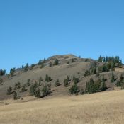
Sheephorn Peak Revised by Livingston Douglas

Climbing and access information for this peak is on Page 302 of the book. Note that in the book the elevation is listed as 10,655 feet. Based on recent LiDAR updates, the peak’s elevation is 10,469 feet. Livingston Douglas revised this page, adding upgraded access, route information, and new photos. Additionally, he has provided route information for those interested in … Continue reading

Peak 10340 (Gilcrest Peak)

This peak is not in the book. Gilcrest Peak is located on the Continental Divide, roughly two miles north of Mount Carpenter. The name Gilcrest Peak was suggested by Rick Baugher to commemorate Murray Havens Gilcrest who, during the Summers of 1905 and 1906, was a transit man with the Carpenter Stateline Survey and, no doubt, crossed this summit during … Continue reading

Peak 9722 (Hells Hole Peak/Little Elk Peak)

This peak is not in the book. Hells Hole Peak is located north of Mount Baird in the Snake River Range. This peak is unofficially identified as both Hells Hole Peak and Little Elk Peak. However, the Board of Geographic Names frowns on duplication of names. As “elk” is one of the most common names used in Idaho, this website … Continue reading

McNutt Peak (Peak 10327)

Climbing and access information for this peak is on Page 296 of the book. McNutt Peak/Peak 10327 is the northernmost Lemhi Range summit of at least 10,000 feet in height. There is good access to this peak and 4 other Lemhi 10ers via the Bear Valley Lakes Trail [(A)(10.2)(a) on Page 316]. Livingston Douglas has provided an alternative and more … Continue reading

Peak 9725 (Goldstone West) by Livingston Douglas

This peak is not in the book. Peak 9725 is located west of the Continental Divide and northwest of Goldstone Mountain. USGS Goldstone Pass East Face, Class 2+ Access The Montana side of the Continental Divide using FSR-7327 from its junction with Skinner Meadows Road/FSR-381 (on Page 331 of the book). Peak 9725 lies entirely within the State of Idaho. … Continue reading