Climbing and access information for this peak is on Page 113 of the book. I do not know of any one who has tried this peak’s North Face. See John Platt’s trip report. USGS Fitsum Summit … Continue reading
Climbing and access information for this peak is on Page 113 of the book. I do not know of any one who has tried this peak’s North Face. See John Platt’s trip report. USGS Fitsum Summit … Continue reading
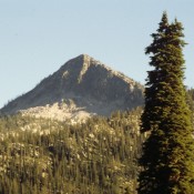
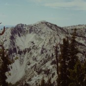
Climbing and access information for this peak is on Pages 146-147. Additional information is set out below. Wolf Mountain is more like a Sawtooth Range summit than most Boise Mountains’ peaks. While it is a long way from a paved road, access is good at least in a relative sense. USGS Jackson Peak FS-312/Graham Road is a long, winding road … Continue reading
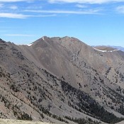
Climbing and access information for this peak is on Page 284 of the book. Use the Dave Pahlas link below to read about his and John Platt’s marathon peak climbing adventure that includes both Massacre peaks. Livingston Douglas added new photos. Updated November 2024 One of two peaks on a massive North-South ridgeline, North Massacre Peak is seldom climbed. I … Continue reading
Climbing and access information for this peak is on Pages 100-101 of the book. Please note that the book’s elevation has been revised slightly to reflect the currently-accepted level of 8,900 feet for Mount Belial. USGS He Devil … Continue reading
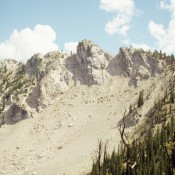
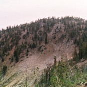
Climbing and access information for this peak is on Pages 147-148. The photo on Page 148 is labeled in error. It is actually another view of Wolf Mountain. Whoops! Matt Durrant pointed out this error out to me. Goat Mountain and North Goat Peak are the two highest points on a North/South ridge line that sits just west of the … Continue reading
Climbing and access information for this peak is on Page 118 of the book. Lake Mountain is located on the western edge of the Frank Church River of No Return Wilderness, north of Landmark. The peak towers over Pistol Lake. I climbed this peak in 2002. Despite its relatively short access, other than hunters, few people venture into this area … Continue reading