Elevation: 9,380 ft
Prominence: 840
This peak is not in the book. Published October 2025
Big Flat Top is a high peak that sits at the head of four drainages: Richardson Canyon, Flower Garden, Rough Canyon, and the South Fork Alder Creek. It can be climbed from Cherry Creek Road to its south or from Alder Creek Road to its northeast. USGS Shelly Mountain
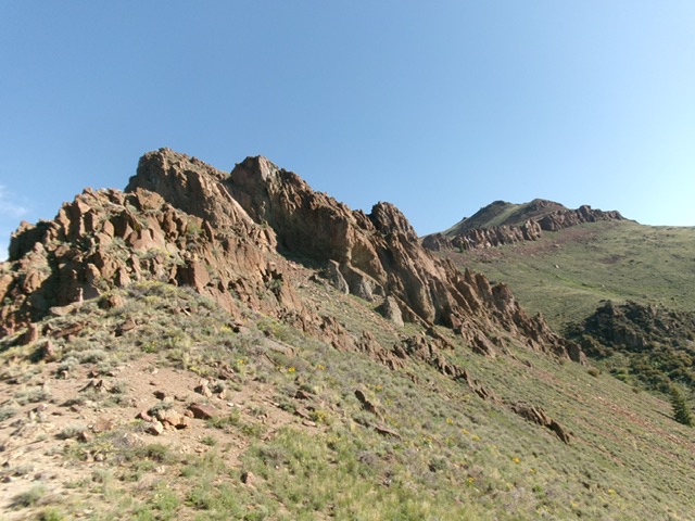
Big Flat Top (hump right of center in distance) as viewed from high on the south ridge. The massive rocky outcrop left of center is the second major ridge obstruction to work around. Livingston Douglas Photo
Access
Same as for Middle Mountain. Drive 3.0 miles up rugged Cherry Creek Road from the unsigned road junction on the valley floor. Turn right/north onto [unsigned] Flower Garden Road and drive 0.6 miles to a nice pullout on a knoll and just before a sharp drop to cross a rocky, narrow gulch. Park on this knoll [6,595 feet and 43°44’33.4”N, 113°39’03.9”W].
Map Updates and Other Corrections
The road closure fence is lower than Baugher states. It is now at 6,950 feet, though the old 2-track road continues after that point and can be hiked. The old 2-track soon forks (not shown on maps). With a jeep or ATV, you could drive to the road closure gate and shorten this hike by two miles. The actual summit high point is only five feet higher than the Knob Benchmark (9,350 feet). The 9,355-foot high point is considerably less than the 9,380-foot figure used by LOJ. The final high contour line seems to be a map error.
Southwest Spur/South Ridge, Class 2+
The Climb
From the parking spot, hike just under a mile up the Flower Garden jeep/ATV road to its gated closure. Continue hiking east up the 2-track road to an unmapped road junction. Go left/north here and follow a spur road to its quick end in less than 0.2 miles. Scramble north across a minor gully then cross a difficult fence row (shown on maps). Head right/northeast briefly to reach the ridge crest. Scramble left/northwest here and follow the scrub-and-talus/scree ridge up to a right/north bend. Continue north up to a ridge point just west of ominous Point 8343.
Pick up a good game trail that connects a saddle just west of Point 8343 to a saddle just north of Point 8343. Once on this higher saddle, you are on the south ridge proper. Scramble north-northwest on the narrow ridge and skirt (or climb over) three rocky ridge points to reach the base of a very ominous, cliff-band protected ridge point (Point 8640+). Thankfully, there is an easy way to get up over this monster. Follow the base of the cliffs northwest and soon stumble upon a steep, rocky (Class 2+) chute heading right/north up to the top of the cliff band.
Once atop this chute, scramble diagonally right/northeast (only rising 10 vertical feet) then drop 35 vertical feet to a saddle just north of Point 8640+. From this saddle, head north up through steep-ish rock and scrub. Climb a chute (with a game trail to help) that sits between two prominent blocks/towers and reach a tilted grass/scrub plateau. From this point, scramble northeast across this easy dirt/scrub plateau which soon becomes rockier with sagebrush mixed in. Reach the rocky finishing ridge just south of Knob Benchmark.
Stay in grass/scrub to avoid the talus/scree slopes on the southwest side of the ridge. Once on the ridge crest, scramble north up the rocky ridge (Class 2+ chutes) or on its right/east side in a rock/scrub mix to reach Knob Benchmark. The USGS benchmark is still there with another benchmark pointing to it. Some triangulation wood and wiring still remain. Continue north down to a saddle (30-foot drop) and scramble up to the flattish summit plateau. The high point is near the south end. I built a nice cairn atop the high point.
Point 8243 (the first ridge obstacle) as viewed from the ridge saddle to its north. Livingston Douglas Photo

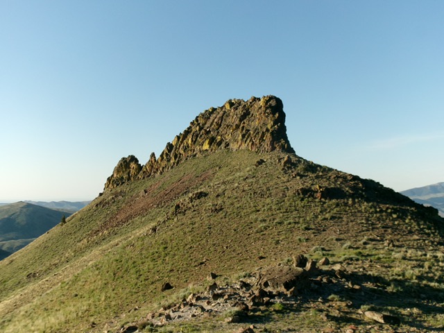
The flat summit of Big Flat Top with its newly-built summit cairn. The [lower] south summit is in the distance, just left of center. Livingston Douglas Photo
Additional Resources
Regions: EASTERN IDAHO->White Knob Mountains
Mountain Range: White Knob Mountains
Longitude: -113.6416 Latitude: 43.7821