Elevation: 9,943 ft
Prominence: 2,264
Climbing and access information for this peak is on Page 323 of the book. Updated October 2025
Goat Mountain is a side ridge that extends southwest from the Continental Divide. It is due southeast of Lemhi, Idaho. Goat Mountain can be climbed either via its south ridge from a few miles off ID-28 or from the Continental Divide via a narrow ridge traverse over East and West Peak (9,924 feet). has a massive amount of prominence (2,264 feet). It is one of 23 peaks Idaho peaks with the word “Goat” in their name. USGS Goat Mountain
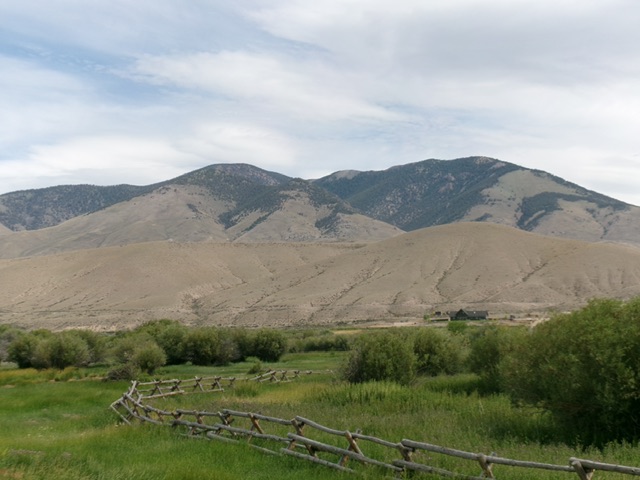
Goat Mountain as viewed from ID-28 to its south. Livingston Douglas Photo
Updated South Ridge Access Information, July 2025
The Baugher access route (linked below) up Little Eightmile Creek is currently blocked by gated, posted private property. You must find an alternative route.
From ID-28 exactly 7.3 miles northwest of the junction of ID-29/ID-28 in downtown Leadore and at virtual MM97.6 (and 0.1 miles northwest of the signed junction with Cottom Lane South), turn right/northeast onto [unsigned] Cottom Lane North. Drive 0.4 miles and reach an unsigned “T” junction. This is Old Highway 28/Foothills Road. Go left/northwest here and drive 1.3 miles to a signed junction with a BLM-signed road for Cedar Gulch. Reset your odometer here. At 0.8 miles, reach an unsigned road junction. Left is Cedar Gulch Road. Right is Buckhorn Mine Road.
Both roads will get you to the Buckhorn Mine. Buckhorn Mine Road goes directly to the Buckhorn Mine in 2.0 miles. Buckhorn Mine Road has steeper sections than Cedar Gulch Road but is a bit less rocky. Cedar Gulch Road is a slightly shorter route. If you go left onto Cedar Gulch Road (do not reset your odometer), at 1.1 miles, go straight (not right). At 2.0 miles, go right. At 2.3 miles, merge into Buckhorn Mine Road and follow it briefly to reach the short spur road up to the old mine. Park at the old mine [6,710 feet; 44°47’20.3”N, 113°27’45.5”W].
This is the first leg of a 2-peak adventure that includes Goat Mountain and East and West Peak (9,924 feet). It covers 8.5 miles with 3,950 feet of elevation gain round trip.
Southwest Spur/South Ridge, Class 2
The Climb
From the Buckhorn Mine, scramble north-northeast then northeast up a magnificent broad shoulder (the southwest spur) of short scrub and relatively-stable gravel. The shoulder narrows and becomes more of a ridge higher up. It has scattered firs and a thicker pine forest after that. Downed trees become a bit of a headache in the semi-open pine forest. Reach a merger with the south ridge at Point 8680+. Continue climbing northeast then north along a narrow, up-and-down, forested pine ridge crest with a good amount of downed trees to work around and underlying loose scree. This section is a bit tedious.
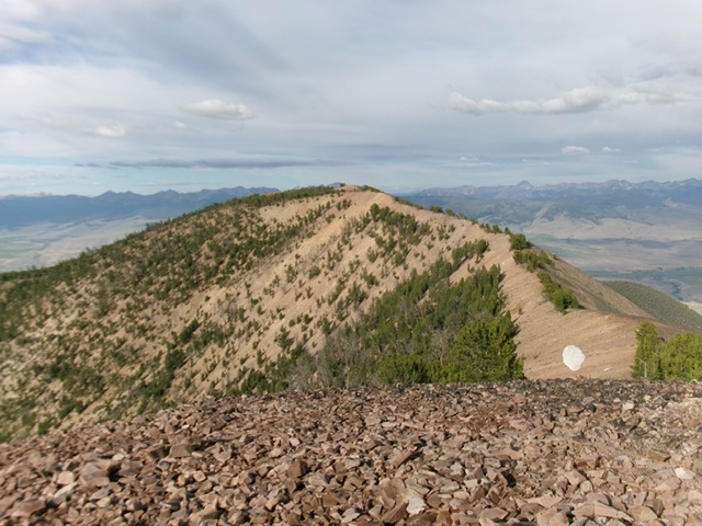
Reach a gentle lengthy gravel saddle just north of Point 8858. This saddle sits at the base of the steepest section of the south ridge. Bushwhack north up through a semi-open pine forest with lots of blowdown and loose scree. High up, reach tree line (of sorts) and much more open terrain. The south ridge merges into the west ridge and now heads right/northeast then bends left-ish/north to the summit hump of Goat Mountain.
The ridge terrain is initially easy tundra and broken rock then is a talus/scree traverse. A false summit hump has multiple cairns atop it. Descend 20 feet from the false summit and continue up easy scree to the true/small summit of Goat Mountain. There is a large summit cairn with a large post in it and two USGS benchmarks nearby. I stood the dilapidated triangulation tripod up on the cairn and secured its legs with talus.
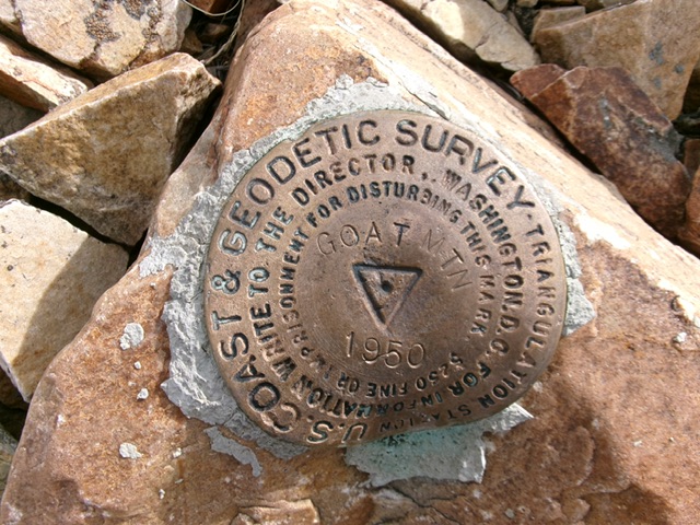
The USGS benchmark atop Goat Mountain. Livingston Douglas Photo
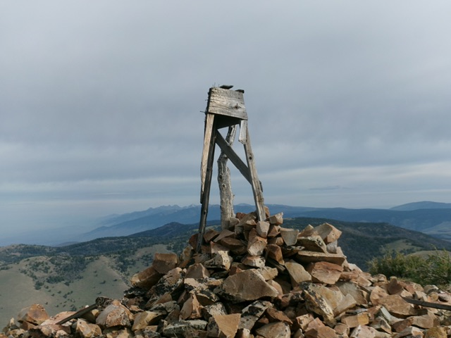
The summit of Goat Mountain with its resurrected tripod standing proud. Livingston Douglas Photo
Northeast Ridge, Class 2
The Descent (then Ascent)
From the summit, head northeast down a magnificent patch of easy tundra early on to a narrow ridge section and connecting saddle at 9,820 feet. The ridge terrain is open rock (scree/gravel) with scattered ridge pines. Nothing too difficult but a bit tedious. There is a goat trail along much of this ridge section to help. This concludes the first leg of today’s 2-peak journey. East and West Peak (9,924 feet) is up next.
Northeast Ridge Route from the Continental Divide
Access and Approach, Class 2
Same as for Peak 9180. Climb Peak 9180 then continue west on the Continental Divide on an old 2-track ridge road until it turns right/north to leave the ridge and skirt the east side of Goat Mountain. The CDT follows the old ridge road northward here.
The Climb, Class 2-3
Leave the road/CDT and scramble southwest then west to reach the north end of Goat Mountain. Follow the narrow ridge crest south to East and West Peak (9,924 feet). Descend southwest from East and West Peak to a saddle at 9,820 feet. Continue southwest along the narrow ridge crest up over a minor ridge hump to reach the summit of Goat Mountain.
Goat Mountain (ridge hump at far left) and East and West Peak (ridge hump left of center) as viewed from Peak 9180 to the east. Livingston Douglas Photo
Additional Resources
Regions: Beaverhead Range->EASTERN IDAHO
Mountain Range: Beaverhead Range
Longitude: -113.43889 Latitude: 44.82339