Elevation: 10,573 ft
Prominence: 825
Climbing and access information for this peak is on Page 303 of the book. The elevation and prominence figures are based on recent LiDAR updates. The book and the USGS quad show an elevation of 10,580 feet. Rick Baugher’s trip report is linked below. It has a discussion of the history behind the name and good photos of the peak. Also see The Deer Creek Foursome by Livingston Douglas for additional information. Updated October 2025
Negro Peak is located above the headwaters of Negro Green Creek in the Lemhi Range. It is a reasonably easy climb from nearby Deer Creek to its east via the east ridge. USGS Gilmore
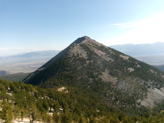
Negro Peak as viewed from Peak 9427 to its east-southeast. Livingston Douglas Photo
Access
Deer Creek Trail [(A)(6.1)(a) on Page 314]. Deer Creek Road/FSR-160 is a brutal road and, except for the first mile or so (up from Junction 6836), is only suited for ATVs and MCs. Prepare to hike most of this road. It is seldom used by motorized vehicles of any kind anymore. This is the first leg of a 4-peak adventure that includes Negro Peak, Smithie Peak (10,263 feet), Peak 10336, and Peak 10177. It covers 11.5 miles with 4,600 feet of elevation gain round trip.
Route map for The Deer Creek Foresome.
Map Errors
There is a helpful, unmapped 2-track that heads up the lower section of the east ridge for just over ½ mile. The USGS topo map fails to show the old road (now a foot trail) that continues up Deer Creek well past the two old cabins where the jeep/ATV trail ends at about 8,360 feet.
East Ridge, Class 2+/3
The Climb
Drive (or hike) up Deer Creek Road to an unsigned road junction at about 7,550 feet. Go right/west here onto an unmapped 2-track that quickly reaches the crest of the east ridge. Follow this 2-track south-southwest then southwest up the forested ridge. The old road becomes a foot/game trail at times but then reappears. After just over ½ mile, the road ends for good. Thanks to the old 2-track, game trails, and an easy pine forest, the east ridge is an easy climb early on.
Higher up, the ridge terrain has a rockier base and there is a section of thick-ish pines, firs, deadfall, and rock. This section is a bit tedious. These more tedious sections permeate the flattish, saddle-like areas of the east ridge. The ridge wiggles a few times and becomes rounded and less well-defined. High up, the pines become more scattered but still persist far higher than you would expect. Finally, the pines disappear and the ridge becomes a Class 2 scramble up lichen-covered quartzite boulders and talus.
Reach a flat, easy area at the north end of the summit cap. Scramble along a narrow ridge crest that heads south over Point 10555 (a rocky outcrop). This ridge section is very choppy and tedious. It requires patience. The high point of Negro Peak is at the south end of the summit cap. It is a gentle hump and is cairned.
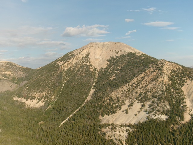
Negro Peak as viewed from high on Smithie Peak to its southwest. The south ridge (my descent route) is in center and just left of center coming at the camera. Livingston Douglas Photo
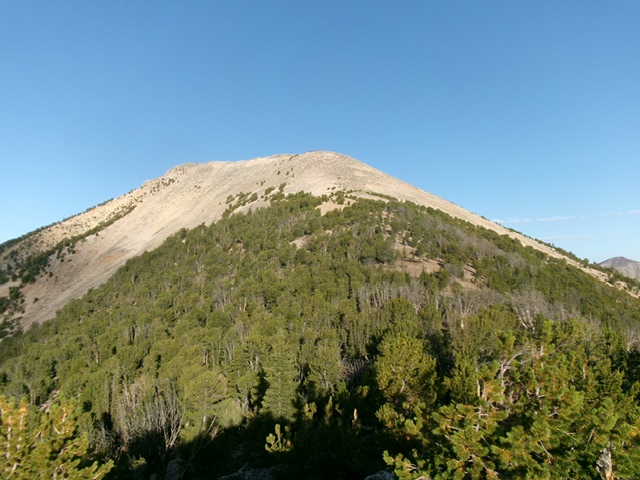
Negro Peak and its upper east ridge (center). This was the final leg of my ascent route. Livingston Douglas Photo
Southwest Ridge, Class 2+
The Descent
From the summit, descend southwest down through talus and over a ridge tower/outcrop. From there, bushwhack down through a thick-ish, but easy, pine forest to reach the 9,737-foot connecting saddle with Smithie Peak (10,263 feet). This concludes the first leg of today’s 4-peak journey. Smithie Peak is up next.
Additional Resources
Regions: EASTERN IDAHO->Lemhi Range
Mountain Range: Lemhi Range
Longitude: -113.3611 Latitude: 44.482439