Elevation: 6,989 ft
Prominence: 1,639
This peak is not in the book. Published October 2025
North Hansel Mountains HP is located due east of the Stone Reservoir and the Curlew Valley. It is most easily reached from the Holbrook-Stone Highway to its west. USGS Co-op Spring
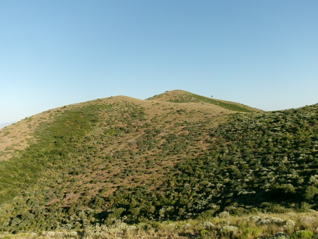
North Hansel Mountains HP (hump in dead center) as viewed from the southeast. This was my final approach to the summit. Livingston Douglas Photo
Access
For a solo climb of North Hansel Mountains HP, the best access is from FSR-013 along the Holbrook-Stone Highway (5.0 miles south of ID-38). See the Baugher trip report for more details. However, to climb both North Hansel Mountains HP and nearby Peak 6850, the better access is from FSR-014 another 1.4 miles south on the Holbrook-Stone Highway.
Drive east up FSR-014 for 1.3 miles and park at a gated closure. This is the end of the road [4,917 feet; 42°04’24.4”N, 112°37’49.8”W]. Please note that there is another, unmapped 2-track that continues northeast from here along a fence row. I’m not sure where that 2-track goes. This is the first leg of a 2-peak adventure that includes North Hansel Mountains HP and Peak 6850. It covers 9.0 miles with 3,225 feet of elevation gain round trip.
Map Errors
The USGS topo map fails to show a 2-track ridge road that covers much of the traverse between North Hansel Mountains HP and Peak 6850.
West Shoulder/South Ridge, Class 2
The Climb
From the gated road closure, cross the gate and head southeast toward the obvious west shoulder. The large drainage to the southeast of the gated road closure separates the west shoulder of North Hansel Mountains HP from the northwest ridge of Peak 6850. Scramble up steep, but easy, gravel and short scrub to reach the crest of the west shoulder. Head southeast then east up this easy shoulder of scattered junipers, gravel, and short, gapped scrub to come up over Point 6340. Drop 50 vertical feet to a saddle then continue east then southeast up this endless ridge to finally reach the critical bare hump that is Point 6982.
It is a discouraging sight from here to North Hansel Mountains HP. Point 6982 is the critical ridge corner between North Hansel Mountains HP to the north (on the far side of a deep gully) and Peak 6850 to the southwest. Reaching North Hansel Mountains HP requires a time-consuming ridge traverse with many ups and downs, both to and from the peak. There are seven (7) ups and downs in total, which adds 650 of extra uphill round trip. Thankfully, there is an unmapped 2-track ridge road to expedite much of this ridge traverse.
From Point 6982, follow a 2-track ridge road east then northeast then northwest to the next-to-last saddle. Leave the road soon after this saddle and contour west-northwest to the final saddle. Once at this final saddle, it is an easy scrub scramble to the summit of North Hansel Mountains HP. The summit has a decent summit cairn.
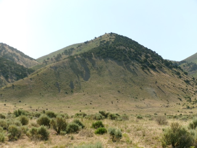
The bottom half of the west shoulder. This was my ascent route. This view is from the valley floor (start of climb). Livingston Douglas Photo
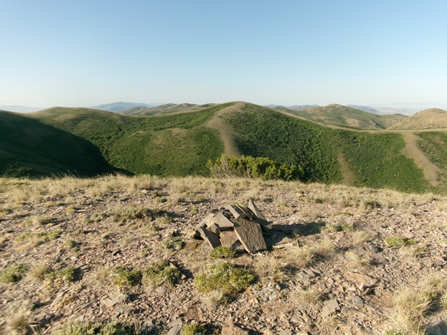
The summit cairn atop North Hansel Mountains HP with competing Point 6982 in dead center to the south. Livingston Douglas Photo
South Ridge/Southwest Spur, Class 2
The Descent
From the summit, return to Point 6982. From there, follow an unmapped 2-track ridge road briefly south then southwest. Leave the road as it begins a southwest rise up over a ridge hump. Descend west then southwest then west in easy, short scrub (initially) with many domestic goat trails. The terrain becomes much thicker with scrub/brush as you descend but gaps and goat trails help get you across a wide, flat saddle area. Stay on the saddle’s right/north side to reach its far side. This is the low point in the traverse between North Hansel Mountains HP and Peak 6850. It concludes the first leg of today’s 2-peak journey. Peak 6850 is up next.
Additional Resources
Regions: North Hansel Mountains->SOUTHERN IDAHO
Mountain Range: North Hansel Mountains
Longitude: -112.59286 Latitude: 42.07133