Elevation: 10,076 ft
Prominence: 350
This peak is not in the book. Livingston Douglas added new ascent and descent routes as well as new photos. The elevation and prominence figures reflect recent LiDAR updates on Peakbagger.com. The USGS quad shows the elevation as 10,077 feet. Updated October 2025
Peak 10076 is located just south of Everson Lake and east of the main Lemhi Range Crest. USGS Yellow Peak
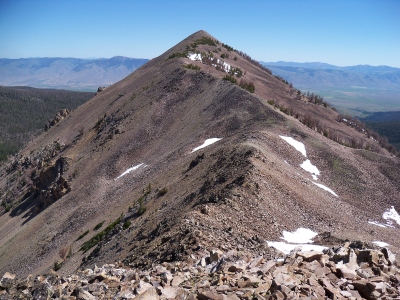
Peak 10076. Rick Baugher Photo
Access
Big Eightmile Creek Road/FS-096 [(A)(9.1) on Page 315]. Follow Big Eightmile Creek Road until you reach its junction with FST-6004 which leads up Dairy Creek. Hike (or ride an ATV/MC) up this ATV trail to its end at Dairy Lake.
West Ridge, Class 2+
From Dairy Lake, climb to the saddle between Peak 10076 and Point 10066. Follow the west ridge to the summit.
East Face and Northeast Ridge/East Face by Livingston Douglas
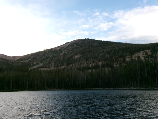
Peak 10076 and its steep east face as viewed from Dairy Lake. This was my ascent route. Livingston Douglas Photo
Access
The [signed] Dairy Creek ATV Trail (FST-6004) is located at the 4.5-mile point on Big Eightmile Road/FSR-096. This road junction is signed for “Dairy Lake 2-1/2 Miles” but the FST-6004 sign is laying on the ground. There is ample parking at this junction [7,180 feet; 44°38’10.7”N, 113°33’19.1”W].
Map Errors
The USGS topo map shows FST-6004 as a 4WD road (it is an ATV trail) that goes into the Dairy Creek drainage and rises well above the creek on its southeast side. The trail actually stays near the creek and goes all the way to Dairy Lake.
East Face, Class 2
The Ascent
Hike up FST-6004/Dairy Lake Trail for about 2-1/2 miles all the way to its end on the northeast corner of Dairy Lake. FST-6004 fords Dairy Creek twice. The first creek fording has a broken-down wooden bridge where the trail crosses to the west side of the creek. Higher up, the trail crosses to the east side of Dairy Creek without a foot bridge. I went downstream and found a braided area with easier logs to cross here. There is an old wooden picnic table at lakeside at the trail’s end.
Hike around the north end of Dairy Lake, initially on a use trail then up over a forested hump. Bushwhack west down to Dairy Creek and cross it. Once across Dairy Creek, bushwhack west up through pine forest to reach a talus/scree slope. Angle right-ish/northwest here and head toward the easier east ridge, which sits above a massive rocky buttress/cliff face. These cliffs extend from 8,600 feet to 8,960 feet. The east ridge is a ways off, so just head northwest then west-northwest up the forested slope of the east face and pop out on the summit ridge (the northeast ridge) just past the final east-side snowdrifts.
Scramble up the easy ridge crest and quickly reach a hump of steep-ish talus. Climb up this hump and continue a bit farther southwest to the cairned high point of Peak 10077. The terrain on the east face is a mix of scattered pines, some blowdown, and moderate to steep scree/gravel. There is very little scrub to speak of. The summit offers nice views of Dairy Lake, Everson Lake, and Gothic Peak.
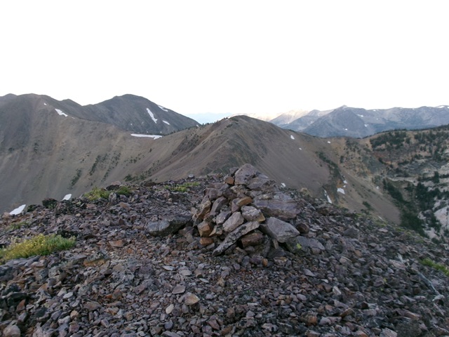
The large summit cairn atop Peak 10076. Livingston Douglas Photo
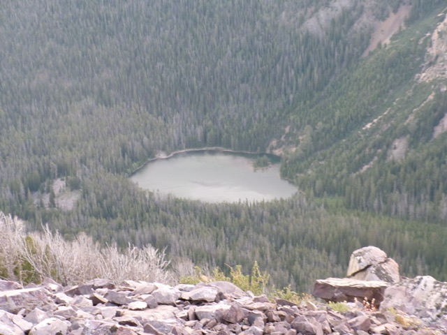
Dairy Lake as viewed from the summit. Livingston Douglas Photo
Northeast Ridge/East Face, Class 2
The Descent
From the summit, head northeast down the ridge crest. Descend the talus hump carefully then cruise down the easy ridge. There is some ridge blowdown but the ridge is not very rocky. The northeast ridge bends right-ish/east and flattens out. Leave the ridge in this flattish area and descend east (or northeast) to intercept the ATV trail where it is on the left/west side of Dairy Creek, below the final creek fording. I came down a bit upstream from this point so I had to bushwhack across open fields of grass/sagebrush (with cattle trails) to reach the ATV trail where it crosses to the west side of Dairy Creek.
The east face descent was in mostly easy, non-rocky pine forest. Avoiding downed timber is the greatest challenge. Lower down, there is some easy open terrain (field grass, sagebrush) within the forest. Stay on open shoulders to expedite the descent to Dairy Creek.
Additional Resources
Regions: EASTERN IDAHO->Lemhi Range
Mountain Range: Lemhi Range
Longitude: -113.60709 Latitude: 44.62279