Elevation: 10,113 ft
Prominence: 332
This peak is not in the book. Paul Lind made the first ascent. According to Derek Percoski, Paul “came up from the northeast and continued with the extremely rugged connection to the main crest (Sheephead).“ They suggested the name “Methodist Peak” after the adjacent drainage. Published October 2025
Thanks to LiDAR updates, Peak 10113 is now a ranked summit. This is a rocky, steep, intimidating peak and will test your scrambling and route-finding skills. Only experienced mountain climbers should undertake this adventure. USGS Mackay
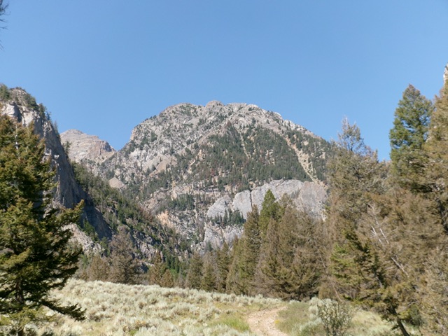
Peak 10113 as viewed from the Bear Creek trail. It is quite an intimidating sight. Livingston Douglas Photo
Access
Bear Creek Trail/FST-092 [(D)(3)(a) on Page 294]. Please note that Bear Creek Trail is now signed as FST-092 not FST-093 as the book indicates. Here are more detailed driving directions to the Bear Creek trailhead. From US-93 southeast of Mackay, drive north up Pass Creek Road for 8.4 miles to an unsigned junction with Bear Creek Road/FSR-430. Go left onto Bear Creek Road and reset your odometer. Drive 1.0 miles up Bear Creek Road to an ATV trailhead (FST-092). Park just below the trailhead on a shaded side road [7,040 feet; 43°59’16.9”N, 113°28’03.5”W].
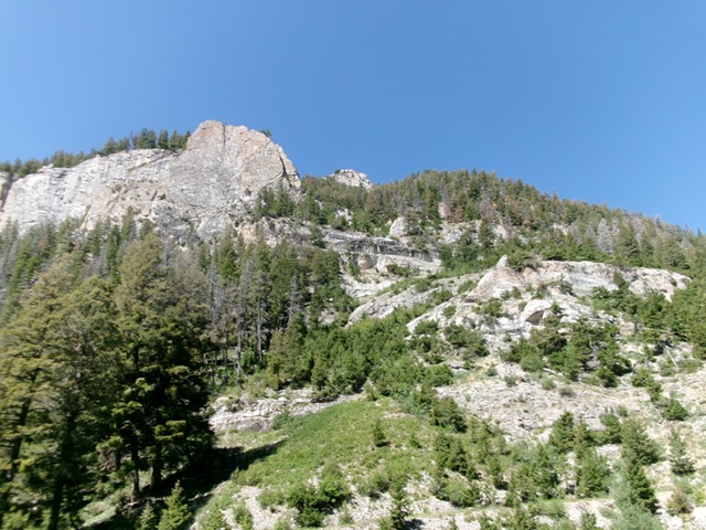
Peak 10113 as viewed from the departure point from the Bear Creek trail. The east shoulder is forested and is right of center. Skirt underneath the cliffs in dead center to reach it via a gully of sorts. Livingston Douglas Photo
East Shoulder/Northeast Ridge, Class 4
The Ascent
From the ATV trailhead, hike up the rocky ATV trail to its end then continue on a hiking trail that leads to a fork in the Bear Creek Canyon. Cross the dry creek bed of Bear Creek and continue right-ish/north for another ¼ mile to a spot where the drop (left) to cross Bear Creek (a small stream) is only 30 vertical feet or so. Leave the trail here. You have a splendid view of the rugged, rocky terrain that awaits you. Look for a forested ridge (the east shoulder) and a cliff band to the left/south of it that leads you up to the ridge.
Leave FST-092 and descend 30 feet in scrub to cross Bear Creek (a small stream here). Once across the creek, scramble up open gravel/scrub that soon becomes forested. Head right/north at the base of a prominent cliff band. Once past the cliff band, bushwhack left-ish/northwest to reach the crest of the forested east shoulder in a mix of forest, grass/scrub, talus/scree, and cliff bands. The east shoulder sits across a prominent gully from a rugged, tower-clad ridge to the left/south. Once on the shoulder, scramble steeply west-southwest in thick forest and loose ridge rock (scree/gravel) with some ridge outcrops as well. This is slow, tedious work.
Higher up, reach an impasse at a massive ridge block. Leave the east shoulder here and contour left/southwest up and across a steep face of loose scree/gravel (and steep face slabs) to reach a chute with a dead tree in it. This chute leads right/west up to an area just below the northeast ridge. Climb the face rock on the left/south side of the chute. Once atop the chute, scramble right/west up more scree/gravel to reach the juncture of the east shoulder and the northeast ridge. Reach the crest of the northeast ridge by climbing a chute/ramp on the left side of a rocky ridge point.
Once on the northeast ridge, get a good look at the upper northeast ridge, which is steep and rocky. The summit area is in the distance, behind a massive ridge block high up. Scramble up the left/southeast side of the choppy ridge crest to reach the base of the large ridge block. Skirt under the left/east side of this block then return right/west above it to regain the ridge crest. Interestingly, this ominous-looking ridge block is a walk-up on its southwest side from the ridge crest above it. Once past this ridge block, climb the rocky ridge to reach the tower-clad summit ridge crest. Stay left/southeast of the ridge crest to more quickly reach the summit area.
The summit ridge area becomes a Class 4 problem, but it is the only way to reach the cairned summit tower. Work through a series of up-and-down, exposed Class 4 towers with fragile rock. This is tedious and dangerous work. Reach the cairned high point amongst the many towers in this area.

The critical “dead tree” chute that gets you back up onto the crest of the northeast ridge. Livingston Douglas Photo
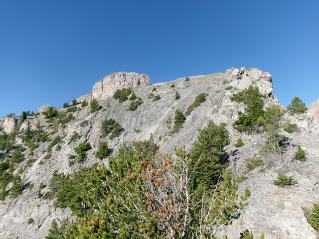
The upper northeast ridge of Peak 10113. This was the final leg of my ascent route. The summit area sits behind the massive block left of center which must be skirted. Livingston Douglas Photo
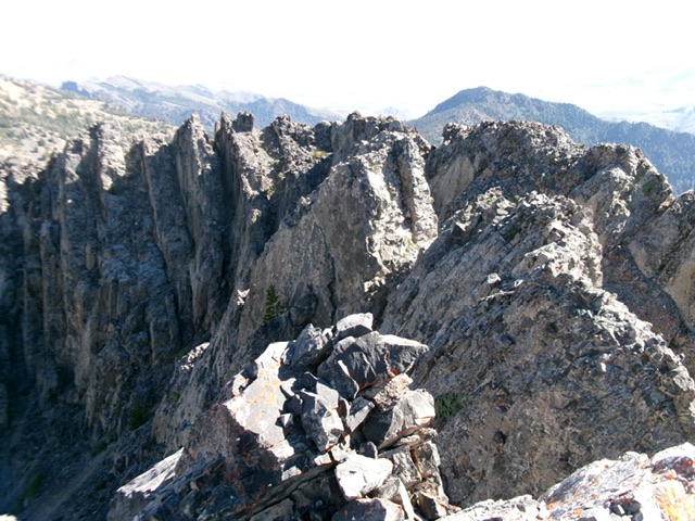
The summit cairn atop the high point of Peak 10113 with the choppy, Class 4 ridge towers of the northeast ridge behind it. Livingston Douglas Photo

Livingston Douglas’ climbing route comes up the east side of the peak.
Additional Resources
Regions: EASTERN IDAHO->Lost River Range
Mountain Range: Lost River Range
First Ascent Information:
- First Ascent Year: 2022
- Season: Summer
- Route:
- Party: Paul Lind
- Other First Ascent: East Shoulder/Northeast Ridge, Class 4
- Year: 2025
- Season: Summer
- Party: Livingston Douglas
Longitude: -113.50580 Latitude: 43.98684