Elevation: 10,177 ft
Prominence: 321
This peak is not in the book. The elevation and prominence figures are based on recent LiDAR updates. The USGS quad shows an elevation of 10,173 feet. Also see The Deer Creek Foursome by Livingston Douglas for additional information. Published October 2025
Thanks to LiDAR updates, Peak 10177 is now a ranked summit. It sits southeast of nearby Peak 10336 and can be climbed in combination with it or directly from nearby Deer Creek to its east. Massive Portland Mountain (10,824 feet) is due east of Peak 10177 and presents an impressive sight. A beautiful, unnamed lake sits in between. USGS Gilmore
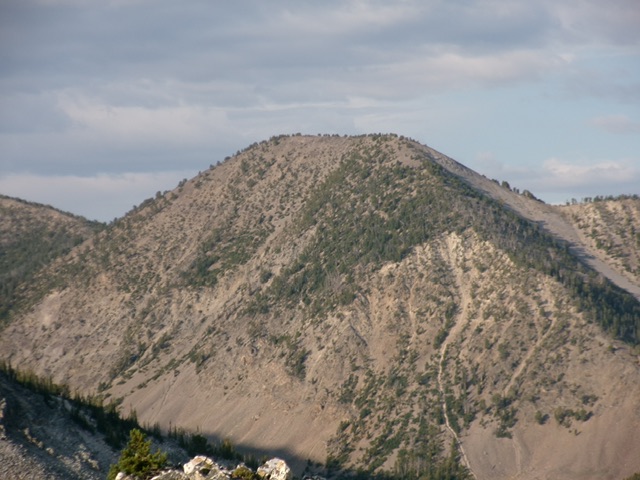
Peak 10177 as viewed from the northeast. Livingston Douglas Photo
Access
Same as for Negro Peak (10,573 feet). This is the final leg of a 4-peak adventure that includes Negro Peak, Smithie Peak(10,263 feet), Peak 10336, and Peak 10177. It covers 11.5 miles with 4,600 feet of elevation gain round trip.
Map Errors
The USGS topo map fails to show the old road (now a foot trail) that continues up Deer Creek well past the two old cabins where the jeep/ATV trail ends at about 8,360 feet.
Northwest Ridge, Class 2
The Climb
From the 9,860-foot connecting saddle with Peak 10336, scramble southeast up a steep-ish, loose ridge of scree/gravel and a few scattered pines. Use zig-zagging goat trails to help advance up this section. Once on the easier summit ridge crest, head right/south through a pine forest and easy ridge rock to reach the high point of Peak 10177 at its south end. I built a nice, new summit cairn on the highest point.
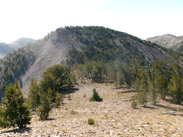
Peak 10177 as viewed from just above its connecting saddle with Peak 10332. This was my ascent route. Livingston Douglas Photo
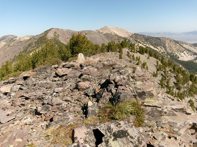
The summit of Peak 10177, looking north along the high ridge crest. Livingston Douglas Photo
North Ridge, Class 3
The Descent
From the summit, return north on the ridge crest down to a ridge juncture at 10,100 feet. Head straight north-northeast and descend a steep ridge of pines, boulders, and loose scree/gravel (Class 3). Keep a major rock gully to your immediate left/west. Lower down, the ridge fizzles out in a steep, loose final descent in talus, scree, and gravel. Enter the wide gully that heads right/east down to the Deer Creek drainage. Cross to the left/north side of the rocky gully and follow its left/north side on the edge of the pine forest as you head east at Deer Creek.
Descend open rock and scrub on the edge of the pine forest and follow the gully down into the pine forest that surrounds the creek drainage. Bushwhack briefly through the reasonable pine forest and find an old road bed (now a foot trail) in a dry creek bed before reaching Deer Creek. Follow this road bed (which, at times, is only a foot path) as it soon crosses to the right/east side of Deer Creek. The foot trail soon reaches two dilapidated old cabins and a trail sign. You have reached the top of the jeep/ATV trail that is FSR-160/Deer Creek Road.
Follow this rocky jeep/ATV trail down past a nice cabin in an open meadow. Continue down the right/east side of Deer Creek on the old road and cross two large downed trees that currently block the road. The road then drops left/west down to ford Deer Creek. Bushwhack downstream a short distance to find tree logs to cross Deer Creek. Once across the creek, return to the road and follow it down to your parked vehicle. The road has two uphills before doing a final descent down into the valley below.
Additional Resources
Regions: EASTERN IDAHO->Lemhi Range
Mountain Range: Lemhi Range
First Ascent Information:
- Other First Ascent: North Ridge—Descent
- Year: 2025
- Season: Summer
- Party: Livingston Douglas
Longitude: -113.35314 Latitude: 44.45405