Elevation: 10,613 ft
Prominence: 673
Climbing and access information for this peak is on Page 256 of the book. I climbed this peak in 1994 by traversing over from Pincer Peak and ascending its south ridge. Livingston has upped the ante with the much more difficult route he describes below. Updated November 2025
Peak 10613 is a magnificent rocky peak that sits on the west side of Muldoon Canyon. Pioneer Mountain (10,525 feet) is to its northwest and Pincer Peak (10,650 feet) is to its south-southwest. The north face/ridge of Peak 10613 is simply brutal. Its east and south aspects go at Class 3 but are not easy. Tackle this peak with great care. USGS Star Hope Mine
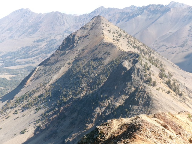
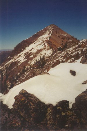
The Claw as viewed from Pincer Peak to its south. Livingston Douglas Photo
Access
Muldoon Canyon/Iron Bog Lake Trail/FST-065 [(C)(3.4)(a) on Page 260]
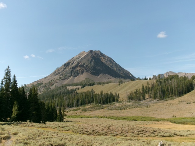
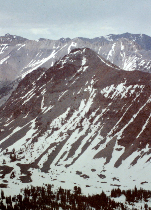
The Claw as viewed from Muldoon Canyon to its north. Livingston Douglas Photo
Map Errors
The Muldoon Canyon Trail stays on the east side of Muldoon Creek and never crosses it. The USGS topo map incorrectly shows it mostly on the west side of the creek.
East Rib/North Ridge, Class 3
The Ascent
From the Muldoon Canyon trailhead, hike about two miles south on the poorly-maintained FST-065 to an open area (in grass) near Muldoon Creek. This area is a short distance off-trail. This spot sits just downstream from a forested hump. Just upstream from that hump is a collection of marshy ponds that must be avoided at all cost. From the open area, cross braided Muldoon Creek and avoid most of the creekside willows. Once across the creek, scramble southwest then west in easy sagebrush. Avoid the patches of willows.
Cross a few rolling hills to quickly reach the base of the massive east face of Peak 10613. Skirt the left/south side of a patch of thick fir trees then head diagonally right/northwest up a rock/grass/scrub ramp (of sorts) underneath a cliff band. Reach a spot where you can easily surmount the narrow cliff band (or continue northwest to its end then come back left/southeast atop it). Another option is to avoid the entire cliff band area by going left/south of it on a scrub slope that leads up to a steep-ish scree/gravel face section. Scramble up the scree/gravel onto the crest of the east rib.
Once atop the cliff band, head straight west uphill in a mix of scrub and rock ledges. Higher up, scramble up a steep-ish talus slope to reach a tilted basin (of sorts) of talus. You are now sitting underneath the east rib (which is to the left/south) and the steep, rocky east face (straight ahead). Scramble diagonally left/southwest up the base of a cliff band to reach the crest of the east rib. Once on the crest of the east rib (which is easy to spot thanks to the scattered pines on it), scramble west-southwest up this ridge of scattered pines, with some large blowdown here and there, to reach the north ridge.
The terrain on the east rib is a mix of pines, ground firs, rocky outcrops, and steep-ish, loose scree/gravel and dirt. It is mostly Class 2 but has a few Class 3 sections. Stick to the solid ground ribs and boulders whenever possible for the best footing. The rib climb ends with a steep-ish talus scramble above tree line up to the narrow crest of the north ridge. Once on the north ridge, scramble southwest up over a rocky ridge point (Class 3) then downclimb 40 feet to a ridge notch (Class 3+) or skirt the left/east side of this ridge point if possible.
From the ridge notch, scramble southwest then south up a talus ridge with several false summit humps along the way. There are a few rocky ridge outcrops and a few twists required to reach the gentle, open summit of Peak 10613. The north ridge is mostly Class 2 scrambling with some ups and downs. It seems like you will never reach the true summit. It is hidden until you get pretty close to it. The endless false summits are annoying.
The Claw and its rugged east face. My ascent line climbs the semi-forested rib left of center. Livingston Douglas Photo
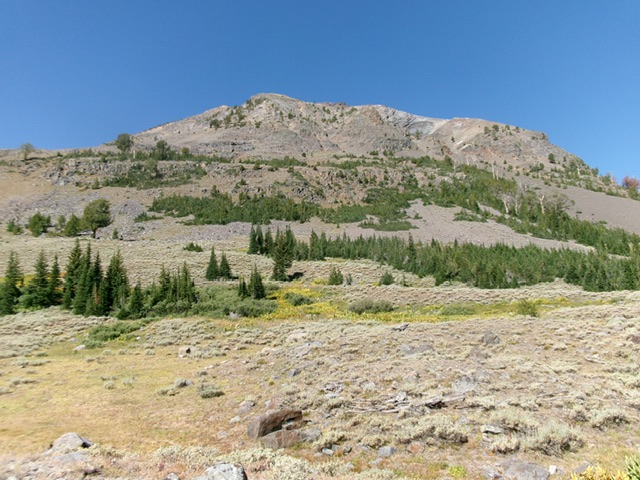
The Claw as viewed from the base of the east face (start of climb) near Muldoon Creek. Livingston Douglas Photo
The Claw (2000). Rick Baugher Photo
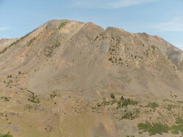
The Claw as viewed from Antares Peak
Additional Resources
Regions: EASTERN IDAHO->Pioneer Mountains
Mountain Range: Pioneer Mountains
First Ascent Information:
- Other First Ascent: East Rib/North Ridge
- Year: 2025
- Season: Summer
- Party: Livingston Douglas