Elevation: 10,692 ft
Prominence: 416
This peak is not in the book. Livingston Douglas revised this page with a new route and new photos. Elevation and prominence figures reflect recent LiDAR updates. Historically, a number of climbers have scrambled over this peak on their way to North Twin. Ken Jones used FS-214 to approach the peak from the north. FS-214 is not in the book and I do not have any first-hand information on this route. Ken Jones’ GPS track which shows this route is set out at the bottom of this page. Reportedly, FS-214 is gated at the point where Ken started. Updated October 2025
Peak 10677 is located on a ridgeline northeast of North Twin (11,088 feet) at the headwaters of Elbow Canyon. It is most easily climbed from the nearby Elbow Canyon drainage and Elbow Canyon Road. USGS Sunset Peak
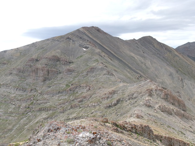
Peak 10692 as viewed from high on the north ridge. The summit hump is right of center. This was the first leg of my descent route. Livingston Douglas Photo
Access
Elbow Canyon Road [(D)(1) on Page 294]. Here are more detailed driving directions. From US-93 southeast of Mackay, drive north on [signed] Pass Creek Road. At 1.2 miles, reach a road merger. Go straight/right to stay on Pass Creek Road. At 3.4 miles, reach a signed junction with Elbow Canyon Road. Go right/east onto Elbow Canyon Road and reset your odometer. This road begins as a decent, gravel 2-track road but quickly deteriorates into a rutted mess of deep dirt. Never drive this road in wet conditions.
At 0.8 miles, go straight at a signed junction. At 2.1 miles, reach a signed junction. Left is signed for Elbow Canyon. Straight is an unsigned, better, road that heads east to a “T” junction at the base of the mountains. If you go left at this junction, drive north then east on a badly-rutted 2-track of deep dirt that follows a fence row east to a “T” junction with a much better 2-track road at the base of the mountains. Reach this “T” junction at 3.0 miles. Alternatively, go straight at the junction and reach a “T” junction with the decent 2-track at the base of the mountains. Go left/north and drive less than a mile to reach the aforementioned “T” junction.
From the “T” junction, drive north for 0.6 miles. The 2-track turns right/east to head up Elbow Canyon. Enter the Challis National Forest here. The road now gets narrow, slow, and rocky. Drive 1.1 miles up into Elbow Canyon and reach an unsigned road junction in a small meadow. Park here [6,860 feet; 43°56’37.3”N, 113°23’06.7”W].
West Face/Southwest Ridge, Class 3
The Ascent
From the road junction, hike east up rocky Elbow Canyon Road to its end soon after crossing a large grassy meadow at a convergence of three canyons. From the road’s end, follow a foot/game trail then bushwhack through easy pine forest (sometimes with the help of a game trail) to reach the obvious right/south bend in Elbow Canyon and the steep west face of Peak 10692. Ignore any side gullies as you ascend Elbow Canyon. Keep heading east with rocky buttresses to your left/north. The sharp bend in Elbow Canyon presents an intimidating sight. Is this climb up Peak 10692 even possible?
From this semi-open juncture, you can see a high ridge saddle (to the left/north) with a gully leading up to it. This will be part of my descent route but is an easier way to reach the summit. However, let’s do something more challenging. Let’s tackle the seemingly-impossible west face well south of this juncture in Elbow Canyon. Scramble southeast then south up Elbow Canyon to reach a large, beautiful meadow/basin that sits at the base of the north face of [imposing] North Twin.
I left the basin early to climb the northwest shoulder of Peak 10692. This shoulder is obvious on the USGS topo map but is not obvious from below. Climb a chute to its left/north then scramble up steep scree to reach its crest. Due to steep cliff bands of solid rock, I was unable to advance up the ridge/shoulder. Head right/south along the base of the cliff band(s) to reach easier terrain. There is a prominent gully that comes up out of the aforementioned high basin/meadow and heads left-ish/southeast up to the ridge crest/saddle that is southwest of Peak 10692.
But this prominent gully has its issues, with intermittent cliff bands of rock to surmount. Stay on the left/north side of the gully and work up through a mix of minor chutes and ribs to advance higher. Scramble directly up the west face on steep talus, scree, and ribs to reach the rocky, but easy ridge crest just left/north of the ridge saddle (10,260 feet). Scramble northeast then east up the rocky ridge to reach the well-cairned summit of Peak 10692. The ridge terrain is a mix of rocky outcrops, hoodoos, and talus. It goes reasonably well and is far easier than the steep west face.
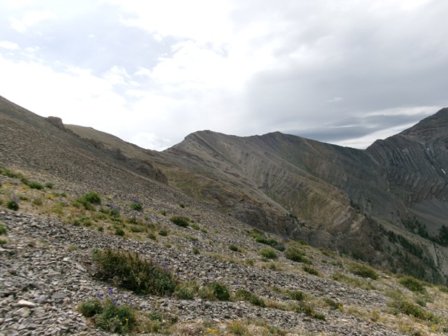
Peak 10692 (summit bump is right of center) as viewed from the northwest. The final leg of my ascent route comes up from the saddle to its right. Livingston Douglas Photo
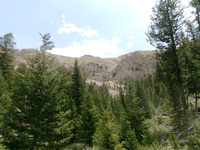
The rugged west side of Peak 10692 as viewed from the south bend in Elbow Canyon. Livingston Douglas Photo
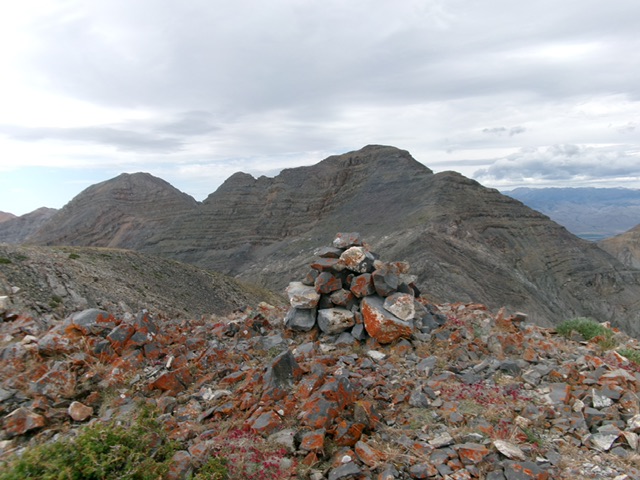
The large summit cairn atop Peak 10692 with North Twin directly behind it. Livingston Douglas Photo
North Ridge/West Gully, Class 2+
The Descent
From the summit, follow the rocky ridge crest (with a nice goat trail in some areas) north-northeast over two ridge humps then down to a notch. From there, scramble north up to Point 10350 on easier talus. This point has rebar protrusions and triangulation posts/wiring and a repeater station (and nice rock shelter) nearby. From Point 10350, descend north then northwest on easy, but somewhat loose, talus/scree to reach the 10,180-foot saddle that sits below (and south of) Point 10358.
The saddle area has easier gravel terrain. From the saddle, descend diagonally southeast to stay in gravel then field grass. Reach tree line and bushwhack down through pine forest. Follow a dry drainage south then southwest to reach the bend in Elbow Canyon. This drainage has some hidden cliff bands to navigate but not too much blowdown. There is an occasional game trail to help. Overall, the forest bushwhack was not too bad but there was a lot of footage to descend to reach Elbow Creek. Follow Elbow Creek back to the rocky road then down the road to the road junction and your parked vehicle.
Ken Jones’ GPS Track
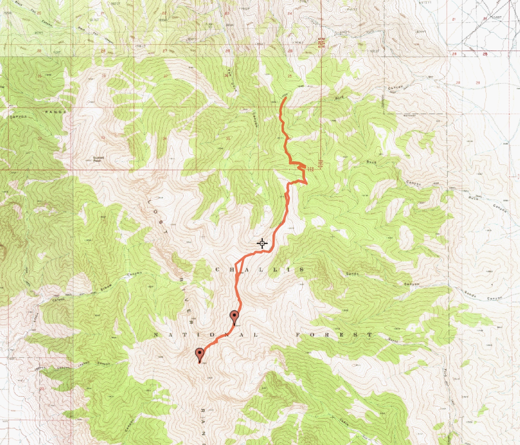
Ken Jones’ GPS track. Trip stats for the North Twin climb: 12.1 miles with 4,005 feet of elevation gain round trip.
Additional Resources
Regions: EASTERN IDAHO->Lost River Range
Mountain Range: Lost River Range
First Ascent Information:
- Other First Ascent: West Face/Southwest Ridge
- Year: 2025
- Season: Summer
- Party: Livingston Douglas
Longitude: -113.32419 Latitude: 43.93769