Elevation: 6,060 ft
Prominence: 480
This peak is not in the book. Published October 2025
Peak 6060 sits above Pennal Gulch and the east side of the Salmon River, northeast of Challis. It is most easily climbed from the nearby Pennal Gulch ATV/Jeep Trail. USGS Challis
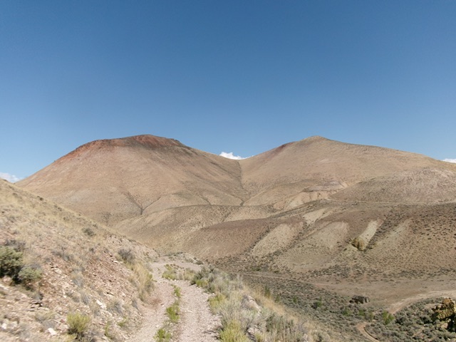
Peak 6060 (left of center) and Point 5920+ (right of center) as viewed from the southeast. Livingston Douglas Photo
Access
From US-93 about three miles southeast of Challis (at virtual MM158.9), turn north onto [signed] Hot Springs Road and reset your odometer. Stay on this paved road (ignore any side roads) for 2.6 miles as it jogs east then northeast then east to reach a signed junction. Go left/north at this junction to stay on Hot Springs Road (straight/east is Upper Hot Springs Road). Drive north on Hot Springs Road for another 1.5 miles to a poorly-signed, gated ATV trail that is just past the well-signed entrance to a ranch and is next to a fenced, private ranch “pen” of farm equipment to the left/north. Park along Hot Springs Road near the cattle gate [4,873 feet; 44°30’52.6”N, 114°09’55.5”W].Don’t block the gate.
Map Updates
Both the National Forest map and the USGS topo map fail to show the numerous roads in this area. There are two early road junctions, other ATV/MC spur trails, and an old 2-track in Pennal Gulch to the west of the ATV trail.
Pennal Gulch ATV/Jeep Trail Approach, Class 1
From the cattle gate, climb over the cattle gate and head east up the unsigned ATV trail for just over ½ mile to a signed junction (not shown on maps). Ignore a signed BLM ATV trail (left) early on and a jeep road to a private ranch (right) soon after. At the signed junction, head left onto [signed] Pennal Gulch Trail. Follow this ATV trail down 55 vertical feet into a gulch that heads north. This trail weaves a bit, goes up and down, and finally bottoms out in a gully heading right/east after about three miles from Hot Springs Road.
Stay on the ATV trail for about 0.3 miles to an obvious gully. Leave the trail and bushwhack up this easy, dry, sage-and-gravel gully (or follow an old 2-track road on the left/north side of the gully) to intercept the ATV trail higher up (to the northeast). Once back on the ATV trail, follow it north then northwest in rockier terrain as it weaves and descends all the way to Pennal Gulch with the remains of an old cabin nearby with an unmapped 2-track heading left/west down Pennal Gulch. This concludes the approach hike.
East Gully/Northeast Ridge, Class 2
The Climb
The ups and downs on this climb are absolutely insane. I recorded 10.0 miles round trip with a whopping 3,350 feet of elevation gain round trip. The net elevation gain from Hot Springs Road to the summit is only 1,200 feet! Be ready for lots of useless ups and downs on this adventure. From Pennal Gulch, continue on the ATV trail north then northwest as it weaves and undulates its way to the east side of Peak 6060. Leave the ATV trail at a good spot where the nearby dry gully is easiest to drop and cross. Scramble west diagonally up and across easy scrub/gravel to reach the east gully.
The east gully separates Point 5920+ from Peak 6060. Follow the easy, dry gully up to the connecting saddle on the northeast ridge. Once at the saddle, head left/southwest (then south) up to the summit. The sagebrush on the northeast ridge is thicker but is still easy. The summit has a band of rock (steep-ish talus) to scramble up and over. It is mostly a talus field. Once atop this rocky section, it is an easy sagebrush bushwhack to the cairned summit. The high point is at the south end and is obvious.
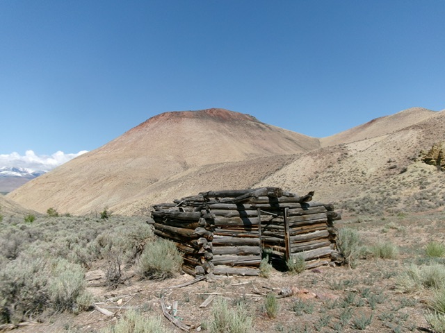
Remnants of an old cabin in Pennal Gulch. Peak 6060 is in the background as is my descent route. Livingston Douglas Photo
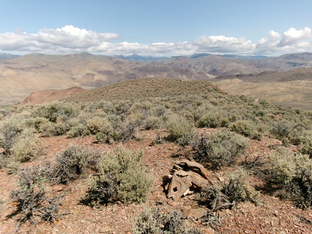
The summit of Peak 6060 with Point 5920+ in mid-ground. Livingston Douglas Photo
Southeast Shoulder, Class 2+
The Descent
From the summit, descend south to a rocky shoulder. Descend southeast from this shoulder down a steep-ish, loose talus (Class 2+) field to reach easy scrub and gravel/dirt terrain below. Boot-ski down the loose gravel to reach the toe of the shoulder in Pennal Gulch. Follow an old, unmapped 2-track road east up Pennal Gulch to quickly reach its junction with the Pennal Gulch ATV trail at the old cabin.
Additional Resources
Regions: EASTERN IDAHO->Lost River Range->Pahsimeroi Range
Mountain Range: Lost River Range
Longitude: -124.1703 Latitude: 44.5579