Elevation: 7,384 ft
Prominence: 364
This peak is not in the book. Published October 2025
Peak 7384 is a foothill in the Pioneer Mountains. Along with its nearby partner (Peak 7263), it sits near the headwaters of Fish Creek. Peak 7384 is most easily climbed from nearby Fish Creek Road and presents no difficulties. USGS Blizzard Mountain North
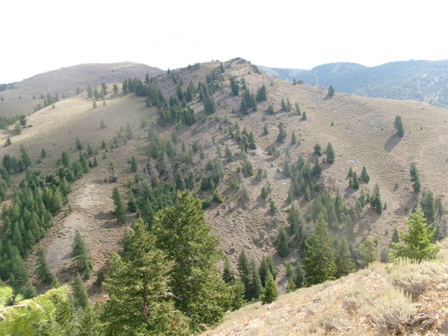
Peak 7384 as viewed from the west. The steep west face is in dead center. This was my descent route. Livingston Douglas Photo
Access
Fish Creek Road is located along US-20 at virtual MM212.1. This road junction is 6.6 miles east of the north end of Carey. Turn north onto [signed] Fish Creek Road and reset your odometer. At 5.4 miles, pass the left turnoff for West Fork Fish Creek Road (signed for “Boat Ramp”). At 6.6 miles, pass the right turnoff for East Fork Fish Creek Road (unsigned). At 9.8 miles, go right at an unsigned junction. At 14.8 miles, reach the Mine Creek Trailhead (right side of Fish Creek Road) at a sharp left/north turn in Fish Creek Road.
Continue another 1.2 miles up Fish Creek Road to a pullout just before the road crosses a feeder stream at the base of the southwest ridge of Peak 7384 (which is obvious). Park here [6,350 feet; 43⁰33’21.7”N, 113⁰43’11.3”W]. This is the first leg of a 2-peak adventure that includes Peak 7384 and Peak 7263. It covers 2.5 miles with 1,825 feet of elevation gain round trip.
Southwest Ridge, Class 2+
The Climb
From the roadside pullout, hike briefly up Fish Creek Road and cross the feeder stream. Reach open scrub on the west side of the southwest ridge. Leave the road and scramble right/east up steep scrub to quickly reach the ridge crest. Follow the sagebrush-and-rock ridge northeast to the south summit. Drop about 10 feet or so then scramble up to the cairned official/north summit. The southwest ridge has a few rocky outcrops to scramble over (Class 2+) or skirt (usually on the left/west side). This ridge is surprisingly rocky, even in the sagebrush, which is not too thick and is gapped. Both the north and south summits measure of equal height and are visually too close to call. Stand atop both “just to be sure.”
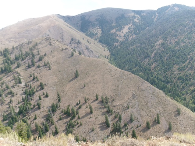
Peak 7384 (in mid-ground) and its southwest ridge (skyline in mid-ground in center and right of center). The summit is well left of center. The southwest ridge was my ascent route. Livingston Douglas Photo
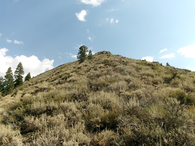
Climbing up the southwest ridge early on. Livingston Douglas Photo
West Face, Class 2
The Descent
From the north summit, descend briefly south to the notch between the two summits. From there, descend west (angling a bit left/southwest initially) in steep-ish scrub and scree. Angle right-ish/northwest to drop into a forest then cross a dry gully to reach an open scrub shoulder. This shoulder aims directly at the toe of the northeast ridge of Peak 7263 and a side gully at its base. Descend the shoulder and drop off its left/north side to reach the Fish Creek drainage and the road. Cross the drainage at a semi-open spot to quickly reach Fish Creek Road. Follow the road about 50 yards or so north to reach the toe of the northeast ridge of Peak 7263 and a side gully. This concludes the first leg of today’s 2-peak journey. Peak 7263 is up next.
Additional Resources
Regions: EASTERN IDAHO->Pioneer Mountains
Mountain Range: Pioneer Mountains
Longitude: -113.7132 Latitude: 43.5624