Elevation: 7,630 ft
Prominence: 450
This peak is not in the book. Published October 2025
Peak 7630 is a rocky peak that sits above Grouse Creek in the foothills of the northern Pahsimeroi Mountains. It is most easily climbed from nearby Grouse Creek Road. The drive to Peak 7630 may be your greatest challenge. USGS Meadow Peak
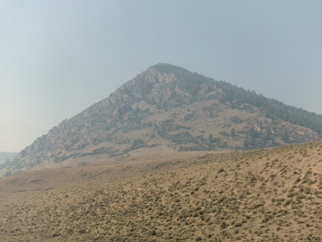
Peak 7630 as viewed from the northeast (start of climb). Livingston Douglas Photo
Access
From US-93 just southwest of Ellis, turn south onto [signed] Custer Road. This is a well-maintained county road that is, effectively, the West Side Pahsimeroi Highway. Reset your odometer. At 13.4 miles, reach a signed junction with Hooper Lane (left). At 15.7 miles, reach a signed junction with Meadow Creek Road. But Meadow Creek Road is only signed on the north side of Custer Road.
Turn right/south onto Meadow Creek Road. This road junction is at 44°31’06.1”N, 115°51’38.5”W. Reset your odometer here. This road is a decent, gravel/rock, 2-track desert road. At 0.1 miles, reach an unsigned, unmapped 3-way junction. Continue straight/south on the middle road (the rockier 2-track to the right/west will eventually merge back into the middle road). At 1.9 miles, merge into the right/west of the two parallel roads. At 2.4 miles, go right at an unsigned junction. At 2.7 miles, reach a signed junction.
Go left onto Grouse Creek Road. At 4.3 miles, go left at an unsigned junction. The road gets rougher now. At 4.4 miles, go right/south at an unsigned junction. At 4.7 miles, go straight/southwest at an unsigned junction with a weaker 2-track road coming in from the left/east. The road gets narrower, more rutted, muddier, and rockier from here. Do not drive any farther in wet conditions. At 5.3 miles, go left/south at an unsigned junction. At 6.4 miles, reach an unsigned junction (Junction 6352 on maps) and a large pullout/campsite. Park here [6,370feet; 44⁰25’54.7”N, 113⁰53’11.5”W].
North Ridge, Class 2-3
The Climb
From the pullout/campsite, bushwhack west-southwest directly at the sage-covered lower section of the north ridge. Once on the ridge, head left/south up into a nice pine forest. Stay right/west of the rocky ridge crest. The terrain steepens and becomes rockier as you advance higher. Midway up, move left/east onto the rocky ridge crest and follow it steeply up to the summit area. High up, mountain mahogany mixed with the blocky ridge rock, making it difficult to navigate.
The final right/west push to the high point is the crux and is a mix of rocky outcrops and thick mountain mahogany (Class 3). You can avoid this section by leaving the ridge below this point and angling left/west through the forest to reach the north side of the summit (Class 2). The high point of Peak 7630 is a few boulders with mountain mahogany mixed in. The highest boulder has mountain mahogany over it.
In an area of scrub hills, Peak 7630 is a rocky, forested surprise. Its east face and south face are rocky, steep, and rugged. Grouse Creek was bone dry when I was here. Wait until the roads have completely dried out (and there is no rain in the forecast) to tackle peaks in this area. Grouse Creek Road would be impassable in wet conditions.
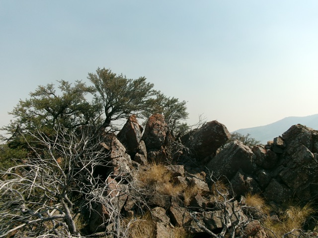
The summit of Peak 7630. Livingston Douglas Photo
Additional Resources
Regions: EASTERN IDAHO->Lost River Range->Pahsimeroi Range
Mountain Range: Lost River Range
Longitude: -113.8959 Latitude: 44.4235