Elevation: 8,298 ft
Prominence: 478
This peak is not in the book. The name is taken from the Peakbagger page linked below. Published October 2025
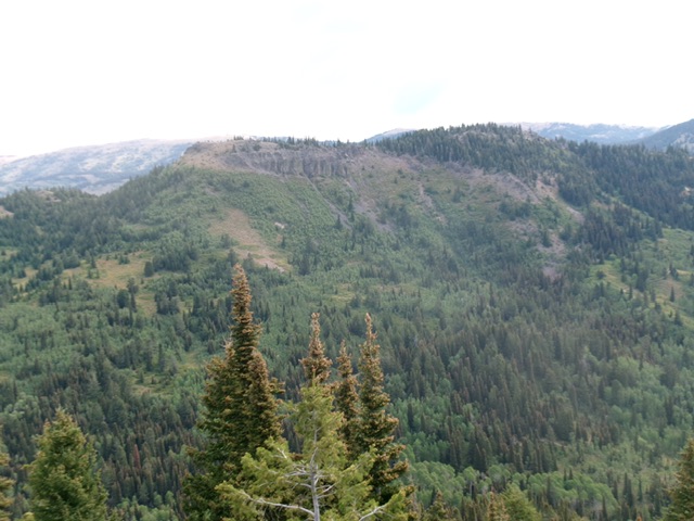
Peak 8298 (the forested hump right of center) and its [lower] west summit (the open ridgeline hump left of center) as viewed from Temple Peak to the southwest. Livingston Douglas Photo
Access
From the north end of Idaho Falls at the Caribou-Targhee National Forest office on US-26, drive 13.6 miles E on US-26 to a signed junction for the Kelly Canyon Ski Area. Turn L/N onto a paved road. Set your odometer to 0.0 here. At 1.9 miles, go right at an unsigned junction. At 3.1 miles, cross the Snake River on a bridge then immediately reach a “T” junction. Go right/east here onto Heise Road. At 5.4 miles, go left at a signed fork in the road.
At 7.9 miles, enter the Caribou-Targhee National Forest. You are now on FSR-218. At 8.9 miles, reach a signed junction with FSR-217 (the “Y” junction). Go straight here to stay on FSR-218. At 19.4 miles, reach a signed junction with FSR-651 (right). Go right onto FSR-651 and drive 1.8 miles east on FSR-651 to its end at the trailhead parking area for FST-077 (an ATV trail). The trailhead is at 7,290 feet and 43°40’11.7”N, 111°26’42.8”W.
Map Errors
The USGS topo map fails to show FST-121/FST-077 as it traverses the south face of Peak 8298 to reach Blacktail Pass. The DeLorme trail map shows this trail segment as FST-077 when it is signed as FST-121. The USGS topo map shows a ridge trail atop Peak 8298 but it is very weak now and the trail down the southeast ridge to Blacktail Pass no longer exists.
South Ridge, Class 3
The Climb
From the trailhead, hike up FST-077 for 1.2 miles to a signed junction with FST-121. Go left to stay on FST-077. Hike another 0.8 miles northeast up Hilton Creek to a signed junction with FST-067/Hilton Creek Trail. Go right to stay on FST-077. Follow the trail east then southeast for another 2.3 miles to reach a saddle and signed trail junction. Head left/north up FST-121 (an ATV trail). It quickly bends right/east and traverses across the south face of Peak 8298. It does gain some elevation in so doing.
Leave FST-121 just after it passes the south ridge (which is obvious). The south ridge leads directly, and steeply, to the east/true summit of Peak 8298. This is a brutal, thick, very steep climb (Class 3). The terrain is a mix of thick scrub, willows, scattered pines, loose scree/gravel, steep rock, and lots of aspens. Look for open areas of easier scrub and move left/west onto the steep, rocky ridge crest to gain some footing as the ridge rock is more solid. Higher up, move right/east onto a broader, easier pine forest ridge and head up patches of open scrub to reach the summit ridge crest.
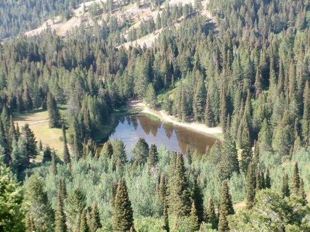
Castle Lake as viewed from the north. Livingston Douglas Photo

The semi-open summit of Peak 8298 with its newly-built, wooden summit cairn, looking west along the forested ridge line. Livingston Douglas Photo
Once on the summit ridge, go right/east and stay in areas of easy, open scrub to reach the bare summit high point at the east end of the summit ridge. This is consistent with the measured high point on the USGS topo map. The ridge pines, mountain mahogany, and ridge willows are a bit of a headache and should be avoided. I built a wooden summit cairn on the high point. There were no loose rocks with which to built a standard summit cairn. I could not find a higher point than this open area at the east end but there are forested areas to the west along the summit ridge that are of similar height.
South Face via West Summit, Class 2+
The Descent
After that brutal ascent route, I sure as hell was not going to descend it. I had to find an easier option and I did. From the east summit, follow the ridge crest west then northwest on an on-and-off foot path to reach the small cairn on the rocky west summit (Point 8280+). Carefully descend southwest on the rocky face just east of the west summit in very loose scree.
Reach open scrub (not difficult) then bash through a thick aspen forest with some willows to boot. Find a few minor areas of open scrub but this is a difficult section to bushwhack. Bend left-ish/south as you descend. Aim to reach the saddle at the base of the northeast ridge of Temple Peak. Lower down, find more open areas of easy scrub and then some easy pine forest. Bushwhack through the pine forest to reach FST-077 at, or just below, the saddle area where this climb began.
Additional Resources
Mountain Range: Big Hole and Snake River Mountains
First Ascent Information:
- Other First Ascent: South Ridge
- Year: 2025
- Season: Summer
- Party: Livingston Douglas
Longitude: -111.3786 Latitude: 43.6589