Elevation: 8,313 ft
Prominence: 497
This peak is not in the book. Elevation and prominence figures are based on recent LiDAR measurements. The USGS Quad shows an elevation of 8300. Published March 2026
Peak 8313 is located above Castle Lake and the Thousand Springs Valley in the Big Hole Mountains. Peak 8313 is a rugged, steep peak that is most easily approached via FST-077 (an ATV trail) at its connecting saddle with Temple Peak.There is much loose, steep rock on this peak so be careful. USGS Temple Peak
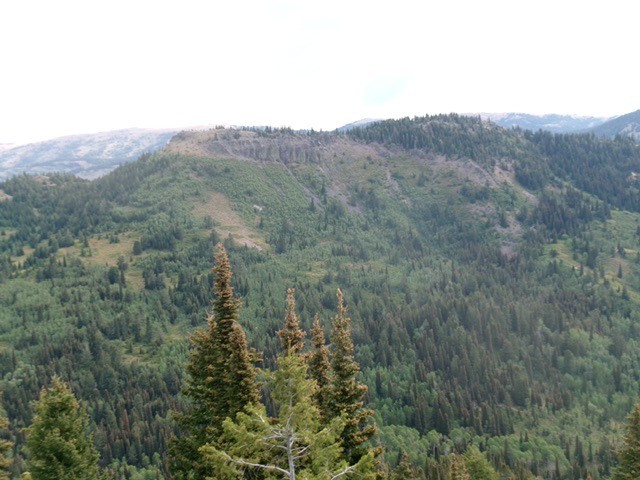
Peak 8313 (open ridgeline hump left of center) as viewed from Temple Peak to its southwest. Livingston Douglas Photo
Access
From the north end of Idaho Falls at the Caribou-Targhee National Forest office on US-26, drive 13.6 miles east on US-26 to a signed junction for the Kelly Canyon Ski Area. Turn left/north onto a paved road. Set your odometer to 0.0 here. At 1.9 miles, go right at an unsigned junction. At 3.1 miles, cross the Snake River on a bridge then immediately reach a “T” junction. Go right/east here onto Heise Road. At 5.4 miles, go left at a signed fork in the road.
At 7.9 miles, enter the Caribou-Targhee National Forest. You are now on FSR-218. At 8.9 miles, reach a signed junction with FSR-217 (the “Y” junction). Go straight here to stay on FSR-218. At 19.4 miles, reach a signed junction with FSR-651 (right). Go right onto FSR-651 and drive 1.8 miles east on FSR-651 to its end at the trailhead parking area for FST-077 (an ATV trail). The trailhead is at 7,290 feet and 43°40’11.7”N, 111°26’42.8”W.
Map Errors/Omissions
The USGS topo map fails to show FST-121/FST-077 as it traverses the south face of Peak 8308 to reach Blacktail Pass. The DeLorme trail map shows this trail segment as FST-077 when it is signed as FST-121. The USGS topo map shows a ridge trail between Peak 8313 and Peak 8298 but it is very weak.
The Approach
From the trailhead, hike up FST-077 for 1.2 miles to a signed junction with FST-121. Go left to stay on FST-077. Hike another 0.8 miles northeast up Hilton Creek to a signed junction with FST-067/Hilton Creek Trail. Go right to stay on FST-077. Follow the trail east then southeast for another 2.3 miles to reach a saddle and signed trail junction. Head briefly left/north up FST-121 (an ATV trail). It quickly bends right/east and traverses across the south face of Peak 8313 and Peak 8308. I climbed Peak 8308 en route to Peak 8313. You can climb directly up Peak 8313 via its South Face/South Ridge from here. I discuss the climbing route for Peak 8313 as a descent route since I reached the peak via its high connecting ridge with Peak 8308.
Ridge Traverse From Peak 8308
The Ascent, Class 2
From Peak 8308, follow the ridge crest west then northwest on an on-and-off foot path to reach the small cairn on the rocky west summit (Peak 8313). The ridge is forested for most of its east half but then opens up and is an easy rock scramble.
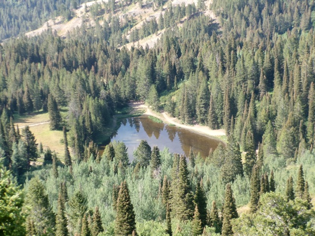
Castle Lake as viewed from the high connecting ridge between Peak 8313 and Peak 8308.
South Face/South Ridge, Class 2+
The Descent
From the summit of Peak 8313, carefully descend southwest on the rocky face just east of the west summit in very loose scree. Reach open scrub (not difficult) then bash through a thick aspen forest with some willows to boot. Find a few minor areas of open scrub but this is a difficult section to bushwhack. Bend left-ish/south as you descend. Aim to reach the saddle at the base of the northeast ridge of Temple Peak. Lower down, find more open areas of easy scrub and then some easy pine forest. Bushwhack through the pine forest to reach FST-077 at, or just below, the saddle area where this 2-peak adventure began.
Additional Resources
Mountain Range: Big Hole and Snake River Mountains
Longitude: -111.38473 Latitude: 43.65972