Elevation: 8,415 ft
Prominence: 515
This peak is not in the book. Published October 2025
Peak 8415 is a scrub hill that is located above the headwaters of Payne Creek and Little Thompson Creek in the foothills of the Pioneer Mountains. Copper Creek Road is to its east and Bell Rock (and Garfield Mountain) is to its northwest. Peak 8415 is most easily climbed from Copper Creek Road. This area is a mix of private and public land, so be careful. This climb is entirely on public land. USGS Muldoon
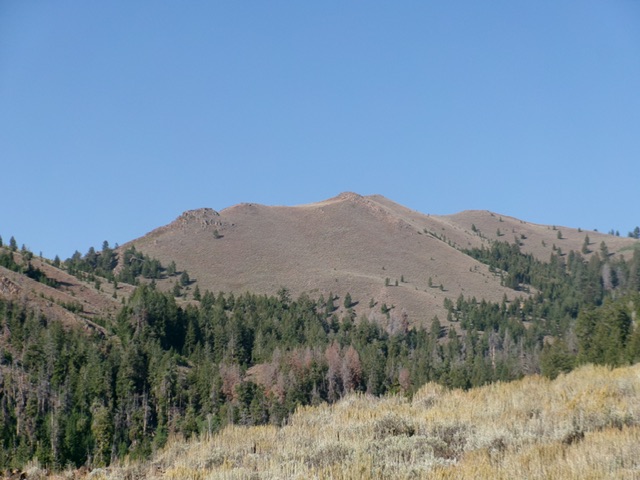
Peak 8415 as viewed from the northeast. Livingston Douglas Photo
Access
Copper Creek Road/Garfield GS Access [(E)(1) on Page 261]. Here are more detailed driving directions. From US-20 at the north end of Carey, turn west onto [signed] Little Wood Reservoir Road. Reset your odometer here. At 13.7 miles, go straight (left is signed High Five Road). At 14.7 miles, go left (right is signed Flat Top Road). At 20.1 miles, go left (right is signed for the Flat Top Ranch). At 23.3 miles, reach the spur road for the Muldoon Canyon Ranch.
Go straight to stay on Copper Creek Road. At 23.6 miles, reach the Muldoon Canyon Road/FSR-126 (right). Stay straight on Copper Creek Road. At 25.3 miles, reach a cattle guard and the National Forest boundary. Park here [6,452 feet; 43⁰35’58.6”N, 113⁰55’16.3”W] or park in a large pullout inside the National Forest.
Map Errors
There are several helpful 2-track roads in this area that are not shown on the USGS topo map.
East Spur/North Ridge, Class 2
The Climb
There is a small patch of private land next to Copper Creek Road here. Consult a land management map to stay on public land. From the cattle guard pullout, bushwhack west (on the north side of a cattle fence) through thick willows and pines to reach Copper Creek. Ford the creek and bushwhack west up onto the toe of the east spur. The better option, however, is to park inside the National Forest and find a cattle trail through the thick willows. Avoid the marshy ponds hiding in the willows and ford Copper Creek. Once across the creek, bushwhack southwest through sagebrush onto the toe of the east spur.
Once on the east spur, quickly find a 2-track road that comes up from a drainage to the left/south and goes up to the crest of the ridge then follows it west-southwest. Follow this unmapped, but very helpful, 2-track road as it moves to the left/south side of the ridge crest and goes for quite a long ways up the east spur. The 2-track skirts past several rocky ridge outcrops and other ridge humps. There is a massive gully to the left/south. This gully separates the east spur (my ascent route) from the east ridge (my descent route).
The old, overgrown 2-track eventually ends abruptly in thick-ish sagebrush. Head left-ish/south here to stay in open scrub just above the gully (left) and on the edge of a pine forest (right). You soon encounter a side ridge heading right/west that goes up to join the main crest of the east spur. Scramble up this easy ridge in open scrub. Once on the main crest, follow it left-ish/southwest and skirt another ridge hump to reach a saddle at 7,660 feet. I contoured around the south side of a ridge hump but still had a 35-foot drop to the saddle.
Pick up another unmapped 2-track road just above this saddle and follow it west to a juncture with the north ridge. Once on the north ridge, follow a good game/use trail up the ridge until it disappears. Bushwhack in easy scrub to reach the cairned summit after dropping 15 feet from a final false summit. I reshaped and enlarged the summit cairn.
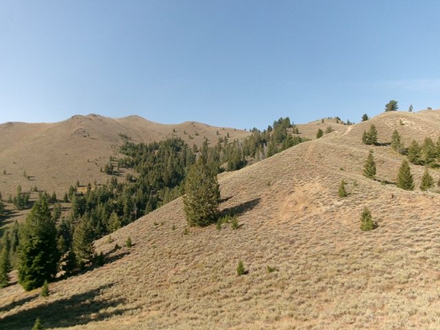
The final push up the easy, open east spur (right of center). The summit bump is left of center. The north ridge is the skyline left of center. This was my ascent route. Livingston Douglas Photo
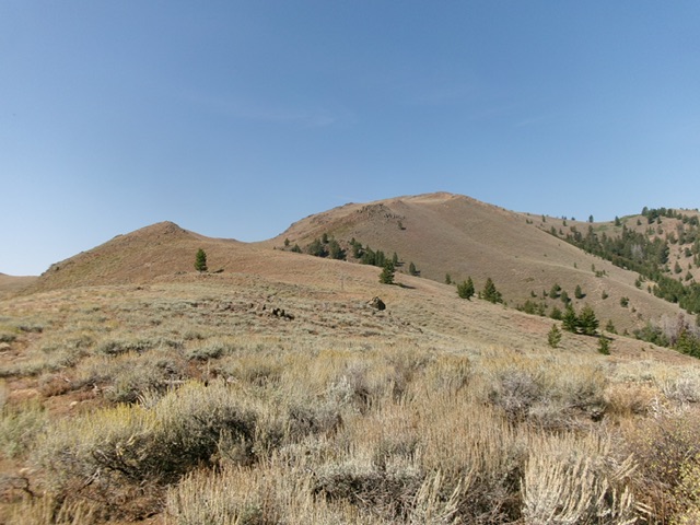
Looking back up the east ridge of Peak 8415 from the midway point. This was the first leg of my descent route. Livingston Douglas Photo
East Ridge/Northeast Spur, Class 2
The Descent
From the summit, descend east then southeast in thick-ish sagebrush to cross a dry gully and skirt past Point 8081 on its left/north side. Contour east through sagebrush slightly to regain the crest of the east ridge. Descend the ridge northeast and cross a dry gully. From the gully, head uphill about 55 vertical feet in sagebrush to get past Point 7840+ and regain the ridge crest. Head northeast then east to reach a critical fork in the ridge at 7,050 feet.
Go left/northwest here. You can now see the valley floor and the National Forest signage near the forest boundary on Copper Creek Road. The large gully to your left/north is the drainage that leads directly back to the National Forest boundary. Keep this critical gully to your left on this entire descent route. It will guide you back to the creek crossing near Copper Creek Road. Descend northwest then north down easy scrub and pick up cattle trails as you lose elevation.
Lower down, pick up an old, unmapped 2-track road and follow it to an unsigned junction with a steep ATV trail that heads left and down to the critical gully. Descend this ATV trail down to the mouth of the gully. Cross to the north side of a stiff cattle fence and bushwhack down to Copper Creek. Ford the creek the bushwhack up to the cattle guard and Copper Creek Road. Alternatively, go upstream a short distance and look for an easy crossing of Copper Creek then follow cattle trails through the thick willows (and marshy ponds) to reach Copper Creek Road at the large pullout inside the National Forest boundary.
Additional Resources
Regions: EASTERN IDAHO->Pioneer Mountains
Mountain Range: Pioneer Mountains
Longitude: -113.9550 Latitude: 43.5879