Elevation: 8,671 ft
Prominence: 331
This peak is not in the book. Published October 2025
Watson Peak separates the headwaters of Copper Creek from the headwaters of Warm Spring Creek. It is overshadowed by its rugged neighbor to the west, Poison Peak (9,364 feet). Watson Peak is most easily climbed from a Forest Service road on its north side. USGS Poison Peak
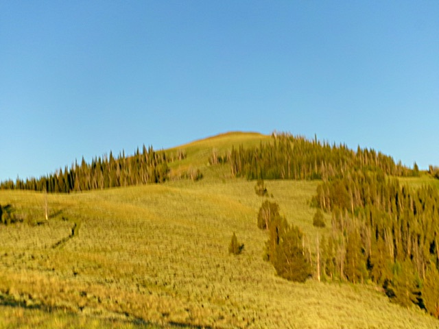
Watson Peak as viewed from the northeast ridge. This was my ascent route. Livingston Douglas Photo
Access
From ID-28 at virtual MM 113.9 (about two miles south of Tendoy), turn west onto [signed] McDevitt Creek Road/FSR-150 and reset your odometer. At 4.1 miles, reach the Salmon National Forest boundary. At 5.4 miles, reach an unsigned road junction with Mormon Canyon Road/FSR-151 (left). Drive 3.7miles up Mormon Canyon Road to reach the high ridge crest and a junction with a weaker 2-track road coming in from the left/east. This is the end of Mormon Canyon Road (signed as FSR-202 here). Reset your odometer here.
Follow a rugged, 2-track ridge road (signed as FSR-196) southwest then northwest up over two ridge humps. The 2-track then descends to a signed junction at 1.6 miles. Go left/west to stay on FSR-196. The road gets much rockier, rutted, and rougher now. At 2.1 miles, the ridge road is now signed as FSR-151. At 2.6 miles, the ridge road is now signed as FSR-007. At 3.2 miles, reach an ugly, narrow fording of Warm Spring Creek. Park in a grassy pullout just before the creek ford [7,630 feet;44°53’54.0”N, 113°49’16.3”W]. This parking pullout is 6.9 miles from McDevitt Creek Road.
This is the first leg of a 3-peak adventure that includes Watson Peak, Peak 8740 South, and Poison Peak (9,364 feet). It covers 8.5 miles with 3,115 feet of elevation gain round trip.
Map Errors
The USGS topo map grossly mis-positions Mormon Canyon Road. The road actually climbs the south side of Mormon Canyon rather than the north side as the map shows. In addition, Mormon Canyon Road is a decent road and is not a jeep trail as the map indicates. FSR-008 is shown leaving the high ridge near Point 8264 and descending down into Mormon Canyon. This unmaintained road is a road to nowhere. It never reaches Mormon Canyon.
The USGS topo map shows a jeep trail heading northwest from just west of Point 8264. That road no longer exists. There is an unmapped, grassy 2-track heading up the east side of Warm Spring Creek from my parking pullout. There is no road going up the west side of Warm Spring Creek as the USGS topo map shows, at least not after the first 0.2 miles. There is no road/trail farther up Warm Spring Creek. There is an unmapped, grassy 2-track heading up the open west side of the northeast ridge of Watson Peak. It weakens but does lead all the way to the summit.
Northeast Ridge, Class 2
The Climb
From the grassy pullout, walk briefly west on the Forest Service road and ford [shallow] Warm Spring Creek. Either continue another ¼ mile northwest to the old 2-track ridge road (my descent route) or follow a 2-track road briefly up the west side of Warm Spring Creek then leave it after it crosses to the east side of the creek. Bushwhack southwest up through thick forest with copious blowdown to reach the open crest of the northeast ridge. Follow the open ridge crest (and the remnants of an overgrown 2-track road when possible) south then southwest to the small summit area. There was no summit cairn so I built one.
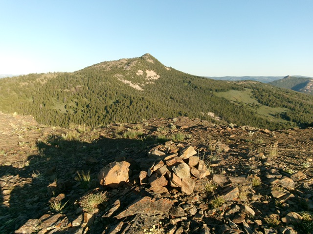
The summit of Watson Peak with Poison Peak in the distance. Livingston Douglas Photo
South Ridge, Class 2
The Descent (then Ascent)
From the summit, descend south then southwest to a minor saddle at 8,340 feet. A barely visible foot trail comes up to this saddle from the west. I use this trail on my eventual return to this saddle later in the day from Saddle 8205 and Poison Peak. The terrain on the south ridge is initially somewhat loose scree and gravel. Easy short grass/scrub takes over with some loose scree/gravel in spots. The 8,340-foot connecting saddle concludes the first leg of today’s 3-peak journey. Peak 8740 South is up next.
Additional Resources
Regions: EASTERN IDAHO->Lemhi Range
Mountain Range: Lemhi Range
Longitude: -113.8396 Latitude: 44.8885