Elevation: 8,743 ft
Prominence: 566
This peak is not in the book. The elevation and prominence figures are based on recent LiDAR updates as found on Peakbagger.com. Published October 2025
Peak 8743 sits at the headwaters of Antelope Creek, Trail Creek, and Horsethief Creek in the southeastern Pioneer Mountains. The peak is most easily climbed via its east ridge from the top of Fish Creek Road. USGS Trail Creek
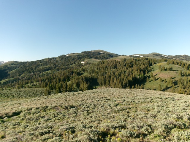
Peak 8743 (in center in distance) as viewed from Point 8015 to its north. Livingston Douglas Photo
Access
There are three alternative ways to reach the northeast spur of the ridge of Peak 8743 from Antelope Creek Road. Each of these routes begins near a bridge crossing of Antelope Creek that is about two miles southeast of Iron Bog Campground. First, follow an unsigned foot trail that is just south of Antelope Creek, near the bridge crossing. The USGS topo map shows a road here but that road is long gone. This foot trail leads west along the south side of Antelope Creek to toe of the northeast spur and to its northwest side.
Second, park at a trailhead parking area about 100 yards south of the bridge crossing. An unsigned trail goes from here up over the toe of the northeast spur then drops to the south side of Antelope Creek, where it heads west then southwest up the creek drainage. Third, park up a short side road that leads to a campsite and a trail heading up Horsethief Creek. This side road is about 100 yards south of the trailhead parking area. From the Horsethief Creek Trail, one can scramble west and quickly intercept the northeast spur. This final access point was my chosen option. The end of the side road is at 6,810 feet and 43°37’35.9”N, 113°43’39.4”W.
Northeast Spur/North Ridge, Class 2
The Climb
From the end of the side road (and trailhead for the Horsethief Trail), follow a foot trail west-southwest along Horsethief Creek. Ignore another trail heading left/south near the start of the Horsethief Trail. After the trail passes a rocky ridge prow, the trail bends left/south and heads up Horsethief Creek. Leave the Horsethief Trail after about ½ mile and scramble west up the steep-ish scrub on the right/north side of a side gully to quickly reach the crest of the northeast spur. This spur initially has the remnants of an old 2-track road on it.
Follow this torturous ridge with its many twists/turns and ups/downs to Saddle #1, Saddle #2, Point 8015, Saddle #3, and Saddle #4. The ridge terrain is generally easy (short grass/scrub) and has elk trails in many areas. There is a short patch of easy pine forest above the minor saddle after Saddle #1. There is very little rock to deal with. The northeast spur ends at a ridge hump just before reaching Saddle #2.
After a 30-foot drop off a final ridge hump (after climbing up from Saddle #4), scramble south-southeast then southwest on the ridge crest in easy tundra to reach a patch of pine forest high up. Head diagonally right/west up through the forest on a wide game trail/clearing to reach open scrub. Continue southwest to the bare summit. There was no summit cairn so I built one on the high point.
The bottom end of the northeast spur of Peak 8743. This was the first leg of my ascent route. Livingston Douglas Photo
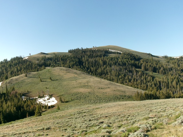
The final push up the north ridge (left of center) to the bare summit (right of center). Livingston Douglas Photo
North Ridge/North Gully, Class 2
The Descent
From the summit, return north to Point 8015. From there, continue northward and skirt the left side of a ridge hump. Continue up over another ridge hump and descend to a minor saddle just south of Point 7987. Leave the ridge and descend east into a drainage that heads north to Antelope Creek. The initial face descent is in thick-ish sagebrush but you will soon find game trails to ease this difficulty.
The drainage itself has a good game trail heading down its left/west side all the way to the south side of Antelope Creek and a foot trail there. Go right/northeast (then east) onto this foot trail and follow it all the way back to Antelope Creek Road just south of the bridge crossing. Hike about 0.1 miles southeast along Antelope Creek Road to the side road then hike 0.1 miles southwest on the side road to your parked vehicle.
Additional Resources
Regions: EASTERN IDAHO->Pioneer Mountains
Mountain Range: Pioneer Mountains
Longitude: -113.7562 Latitude: 43.5882