Elevation: 9,960 ft
Prominence: 324
This peak is not in the book. The elevation and prominence figures are based on recent LiDAR updates. The USGS quad shows an elevation of 9,957 feet. Published October 2025
Peak 9960 is a rugged, rocky peak that is overlooked by climbers. It is a challenging, Class 3 ridge traverse from U Mountain and a steep, challenging forest bushwhack down to the Middle Fork Little Timber Creek Trail. USGS Yellow Peak

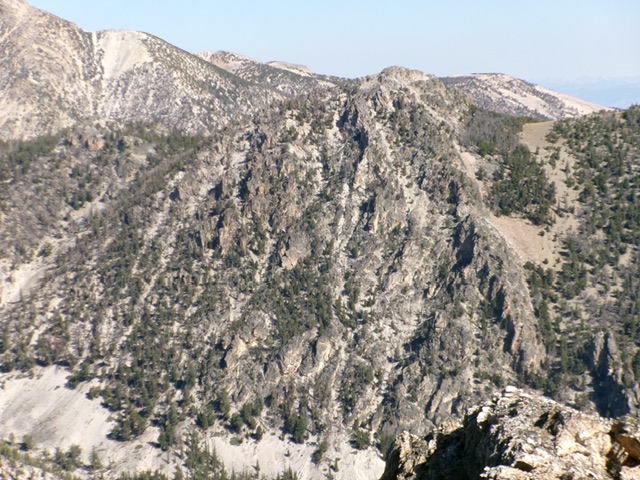
Peak 9960 as viewed from the west. The right hump is the summit block. Livingston Douglas Photo
Access
Same as for U Mountain. This is the second leg of a 2-peak adventure that includes U Mountain (10,542 feet) and Peak 9960. It covers 9.0 miles with 3,700 feet of elevation gain round trip.
Southwest Ridge, Class 3
The Climb
From the small, 9,620-foot connecting saddle with U Mountain, begin an arduous (over an hour), rock-and-pine ridge traverse to get underneath Peak 9960 in an open, grassy field. Follow the rugged ridge northeast up to about 9,800 feet. While the USGS topo map makes it look like contouring at 9,800 feet from here is feasible, it is not. The ridge has several unavoidable ups and downs and a massive block of rock to skirt on its right/south side.
Climb up over a final massive block of rock (Point 9911) to its north side then descend just over 200 vertical feet (Class 3) to a saddle area of open pine forest. From here, angle left/north to get around (and over) a headwall. Once on its east side, climb a Class 3 chute to get atop the headwall. From the headwall, descend a rocky ridge (Class 2+) down to a magnificent, open grassy field at the base of the rocky summit area.
Cross the field and scramble east up an easy, forested face to reach the narrow notch between the [lower] north summit hump and the true/south summit hump. From the notch, scramble right/south up boulders then easy talus/scree to the rocky summit perch. There were no signs of previous ascent. I built a nice cairn atop the tilted, protruding boulder that is the high point.
Rugged Peak 9960 (in mid-ground, center) as viewed from Devon Peak to its southeast. Livingston Douglas Photo

The final push to the summit of rocky Peak 9960. The summit is right of center. Livingston Douglas Photo
Peak 9960 and its rugged east face. The summit block is left of center. Livingston Douglas Photo
South Face, Class 3
The Descent
From the summit, return north to the ridge notch. From the notch, descend a game trail east down to a magnificent open, grassy field. Head right/south then southeast across the field to enter the pine forest. Follow a game trail down through reasonable, but steep, pine forest with a loose scree/gravel base (Class 3 at times). Lower down, the face steepens and ends in a narrow drainage. No game trails here. Bash east then southeast through a mess of downed trees and brush in this wet drainage to eventually reach the Middle Fork Little Timber Creek Trail/FST-187. Follow the trail for ¾ mile back to the trailhead.
Additional Resources
Regions: EASTERN IDAHO->Lemhi Range
Mountain Range: Lemhi Range
First Ascent Information:
- Other First Ascent: Southwest Ridge
- Year: 2025
- Season: Summer
- Party: Livingston Douglas
- Other First Ascent: South Face—Descent
- Year: 2025
- Season: Summer
- Party: Livingston Douglas
Longitude: -113.50150 Latitude: 44.57401