Elevation: 10,720 ft
Prominence: 593
Climbing and access information for this peak is on Page 301 of the book. The elevation and prominence figures are based on recent LiDAR measurements. The USGS quad shows an elevation of 10,723 feet. Updated October 2023
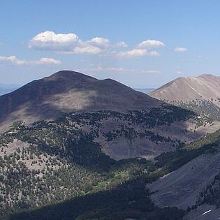
Ray Lode Peak is located on the main Lemhi Range Crest west of Gunsight Peak (10,838 feet) and over 1,600 feet above the Ray Lode Mine to its west. The most direct line to the summit is via its steep northwest ridge from Big Eightmile Creek. USGS Yellow Peak

Ray Lode Peak as viewed from Peak 10624 to its northeast. Livingston Douglas Photo
Access
Big Eightmile Creek Trail/FST-183 [(A)(9.1)(b) on Page 315]. FST-183 is always on the west side of Big Eightmile Creek. The first mile of the trail isn’t even shown on the USGS topo map. This is the first leg of a 2-peak adventure that includes Ray Lode Peak and Peak 10623. It covers 8.0 miles with 3,550 feet of elevation gain round trip.
Northwest Ridge, Class 3+
The Ascent
From the Big Eightmile Creek trailhead, follow the rocky, up-and-down ATV trail for about 1-1/2 miles to reach an area (only partially visible) at the mouth of a gully that separates Peak 10623 and Ray Lode Peak. Leave the trail and find a log crossing of Big Eightmile Creek (not difficult). Once across the creek, bushwhack southeast through miserably-thick creekside forest and brush. Cross a feeder stream to reach a steep pine forest. Stay just to the right/south of the feeder stream to quickly find the toe of the northwest ridge.
Scramble east up through the thick pine forest to where the shoulder gains definition and bends right/south to follow the right/west edge of the stream drainage. Higher up, the ridge moves away from the drainage and forces you to cross a dry gully to the right/west to remain on the ridge. Continue up the forested ridge and reach an open, rocky area just below an ominous ridge outcrop/cliff band. Scramble south then southwest up a steep talus field to skirt the right/west side of this cliff/tower. Once past it, climb left/east to regain the ridge crest.
The face rock here is Class 3+/4 and is the crux of the climb. Once atop this rocky ridge prow/cliff face, follow the steep, rocky open ridge crest south up to Point 9097. The slope eases briefly here then becomes a mix of ridge rock, pines, and talus slopes. Once past the final patch of ridge pines, the ridge bends left-ish/southeast and heads to the summit in open rock. This is mostly talus scrambling with some boulders and scree thrown in for good measure. The summit of Ray Lode Peak is a flattish ridgeline of about 100 feet or so. The official/measured high point is at its east end, though I also visited the west end where someone built a small cairn. The west end measured 10 feet lower.
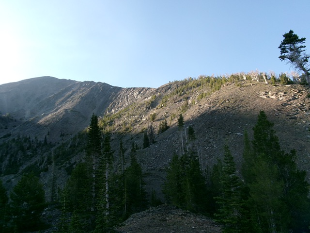
Looking up the northwest ridge from Point 9097. The summit is at far left on the high ridgeline. This was my ascent route. Livingston Douglas Photo
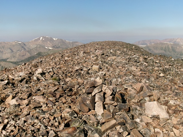
The summit of Ray Lode Peak with its newly-built summit cairn. Livingston Douglas Photo
Northeast Ridge, Class 2
The Descent
From the summit, descend northeast down a rounded, mostly-gentle ridge of scree and then tundra to a wonderful tundra saddle at 10,308 feet. This is the connecting saddle with Peak 10623. It concludes the first leg of today’s 2-peak journey. Peak 10623 is up next.
Additional Resources
Regions: EASTERN IDAHO->Lemhi Range
Mountain Range: Lemhi Range
First Ascent Information:
- Other First Ascent: Northwest Ridge
- Year: 2025
- Season: Summer
- Party: Livingston Douglas
Longitude: -113.55469 Latitude: 44.57709