Elevation: 9,013 ft
Prominence: 89
The exact location of this formation has not been pinned down until recently. Thanks to Derek Percoski I believe this formation’s location is now correctly identified. Some of the confusion was based on the Iowa Mountaineers 1961 AAJ a report that located the formation “west” of Quartzite Peak. Derek summed up his investigation as follows: “I tried to follow their description (set out below and also linked below): This description stated the formation is located ‘west of quartzite.’ Most assume this to mean due west, but we know it might just be west-ish. The Iowa Mountaineers only had crude maps of the range in 1961. The report continues to state ‘on the end of a ridge.’ At first, we’re looking at the topo and inspecting obvious, prominent ridges. But from the view below, everything is a ridge. Finally the Iowa Mountaineers write “[the formation] can easily be seen from the trail.” This is the biggest clue. No ranked ranked summits are readily visibleg from Flatrock Junction on Redfish Lake Creek but this somewhat minor formation is visible.” Published November 2025
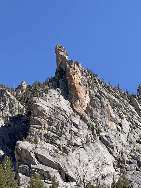
Flat Rock Needle is located to the northwest and above the Flatrock Junction, from which the fork in the Redfish creek trail gets its name, where the trail splits one division to Baron pass the other to the Cramer lakes. Overlooking this area, across the canyon from Chockstone Peak, is a lofty orange colored spire. This spire comprises a spur of the ridge system but is so seperated as to provide a spectacular appearance. USGS Warbonnet Peak
The Iowa Mountaineers AAJ report (linked below) describes the formation and the climb as follows “Flat Rock Needle was the most difficult first ascent of the outing. At the end of a narrow ridge lying to the west of Quartzite Peak, the needle is easily seen from the trail near the Alpine Lake-Cramer Lakes fork, a spectacular rock projection with a sheer orange-colored wall. It was approached by a route that began near the trail fork to the right of the peak and up a narrow couloir. A delicate finger traverse was required to pass a large boulder blocking the couloir. The needle was then approached along the ridge. The final pitch was scaled using tension climbing on the ridge side of the needle. The party consisted of Hans Gmoser, Bill Echo, Dean Millsap, and Clair Brown.”
Access
FS-101/154, Redfish Lake Creek Trail [(A)(6)(b) Pages 206-207]
South Face, Grade I, Class 5.9, A1 by Lyman Dye
The route starts up the main south couloir and would be straight forward except for a boulder blocking the couloir about 4 of the way up. A chimney and delicate ledge system out on the left wall is climbed to the upper level of the couloir. The route on the needle consists of a Court-echelle and a hand traverse on the south side, out about 20 feet to a corner where a mantle move onto a down sloping ledge provides a fair belay stance. The route switches now to the center of the east face, a direct aid pitch, to a platform just below the summit. The move to the summit is short but relatively exposed.
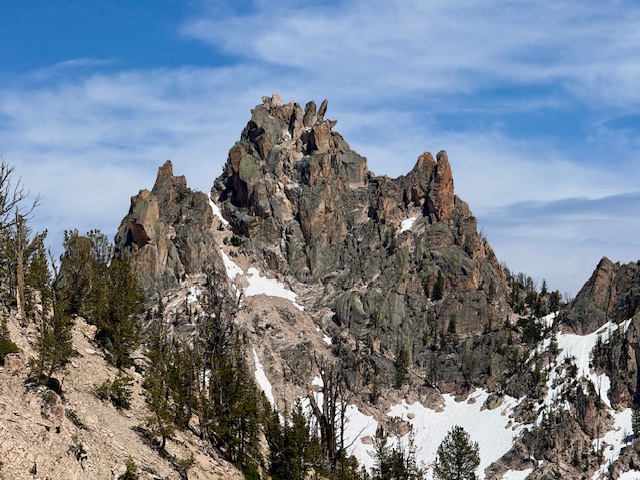
Flatrock Needle on the right. Red Sentinel center and the Chessman on the left. Derek Percoski Photo
Additional Resources
Regions: Heyburn Divide->Sawtooth Range->WESTERN IDAHO
Mountain Range: Sawtooth Range
First Ascent Information:
- First Ascent Year: 1960
- Season: Spring
- Route: South Couloir/West Ridge (II, 5.4 A.1)
- Party: H. Gmosser, B. Echo, D. Milsap and C. Brown
Longitude: -115.00175 Latitude: 44.07822