Elevation: 9,593 ft
Prominence: 1,613
Climbing and access information for this peak is on Page 296 of the book. This update provides current information on the condition of FSR-041 and a somewhat different route to the summit than found in the book. Updated October 2025
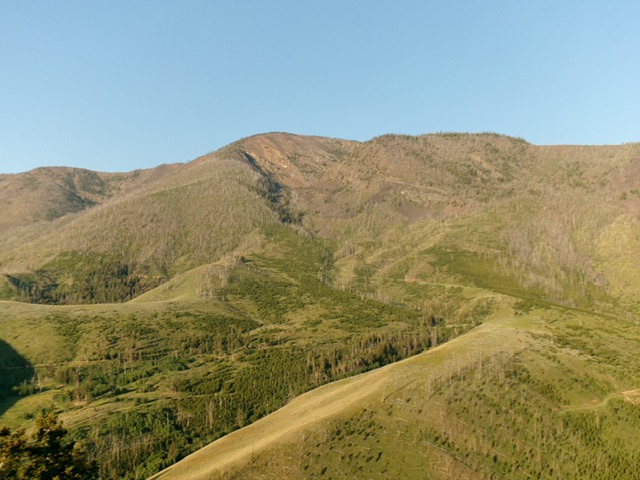
Sal Mountain as viewed from the northeast. The magnificent northeast ridge is just left of center and leads directly to the summit. It is probably the best way to the top. Livingston Douglas Photo
Sal Mountain is the high point on a high ridge that sits just to the east of Twelvemile Creek in the Eastern Salmon River Mountains. Its steep west face can be climbed from Twelvemile Creek Road and its somewhat steep east face can be climbed from the end of FSR-041. Sal Mountain is a former fire lookout site. The old lookout was abandoned in 1940. The trail has not been maintained since then and has mostly disappeared. USGS Sal Mountain
Access
From ID-28 in Baker, Idaho (at virtual MM126.3), turn southwest onto [signed] South Baker Road and follow it for 0.2 miles to a signed “T” junction with Red Rock Stage Road. Go left/southeast onto this road and follow it for 0.2 miles to a signed junction with Withington Creek Road (right). Reset your odometer here. Go right/southwest onto Withington Creek Road. At 4.4 miles, reach BLM land. At 5.2 miles, reach the Salmon National Forest boundary at a road junction. Go left/south here to stay on FSR-031. Drive another 0.8 miles up FSR-031 to a signed junction with FSR-041. This is Junction 5798 on maps. Park here.
Map Errors
The USGS topo map shows FSR-041 continuing as a 4WD road but that road no longer exists. The National Forest map shows FSR-041 continuing south then west up to FST-345. That is inaccurate and FST-345 no longer exists.
East Face/Southeast Ridge, Class 2
The Climb
From the road junction, hike up FSR-041 (a rocky, narrow 2-track only suitable for ATVs/MCs) for about 1-3/4 miles to its end at a fork in the canyon and just below an old mine. This spot is at about 6,850 feet. Contrary to the USGS topo map, there is no 4WD road continuing south from here. This fork is clogged with massive tree logs from an avalanche. From the road’s end, drop 10 feet to cross the South Fork Withington Creek. Scramble up onto a shoulder (in making) that is just left of a prominent, veg-filled gully. This gully leads all the way to the summit ridge and ends just left/southeast of the summit.
Bushwhack west-southwest then southwest then west up this tedious shoulder of scattered downed snags, veg/brush, and loose underlying talus/scree. This shoulder eventually ends in the aforementioned gully. Follow the gully westward to where it steepens and climbs to the crest of the southeast ridge. Leave the gully high up and climb left/south up onto a feeder ridge. Follow this ridge right/west. It soon reaches the southeast ridge. Follow the easy southeast ridge as it drops 10-15 feet to a minor saddle at the head of the aforementioned gully.
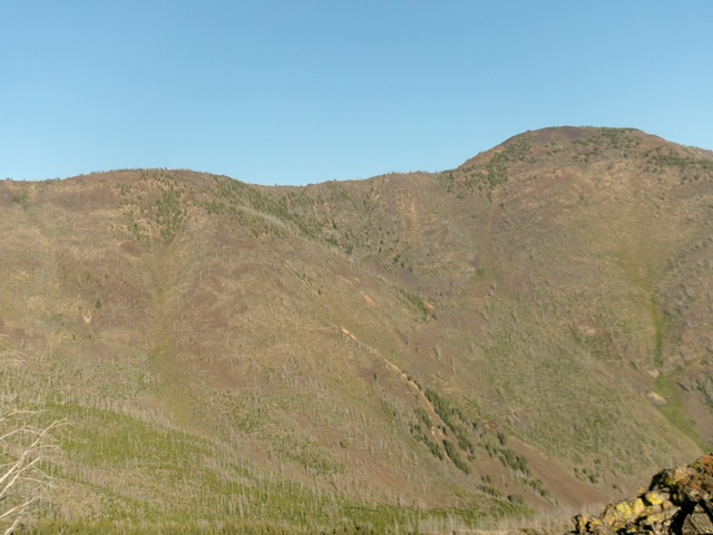
Sal Mountain (its summit hump is right of center) and its southeast ridge (skyline in center and left of center). The southeast ridge was the final leg of my ascent route that begins in the gully in center. Livingston Douglas Photo
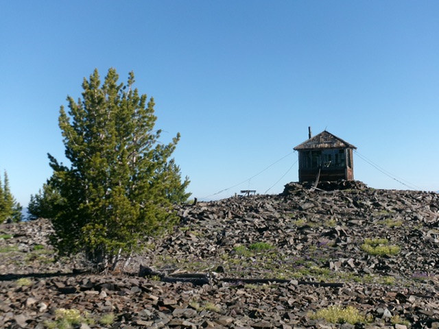
The summit of Sal Mountain with the fire lookout still standing. Livingston Douglas Photo
The southeast ridge now continues up an easy hill of talus. The slope eases and the ridge becomes an easy talus/scree slog to the old fire lookout that is on the summit. The gold USGS benchmark is next to the lookout in a ground boulder. The lookout is a small, 1-room affair with most of the windows now gone and the entrance door lays on the floor.
Southeast Ridge/East Face (Variation), Class 2
The Descent
From the summit, descend briefly down the southeast ridge. Leave the ridge and descend a shoulder of sorts that is on the left/north side of the aforementioned gully. The shoulder terrain is steep, loose talus/scree, some live pines, and downed tree logs. Farther down, drop into a gully that feeds into the main gully, which is farther to the right/south.
Northeast Ridge, Class 2
Probably the best route to the summit of Sal Mountain is its magnificent northeast ridge. You can reach it by driving up FSR-031 up to its signed junction with FSR-030. Drive a short distance south then east on FSR-030 to reach a crossing of the northeast ridge and park here. The ridge is mostly open and is obvious. It leads directly to the summit. It has much more open rock terrain than veg/brush so it should go well and it is not as steep as the east face or the west face. In retrospect, I wish I had done it.
Additional Resources
Regions: EASTERN IDAHO->Lemhi Range
Mountain Range: Lemhi Range
Longitude: -113.84289 Latitude: 45.01519