Elevation: 10,469 ft
Prominence: 324
Climbing and access information for this peak is on Page 302 of the book. Note that in the book the elevation is listed as 10,655 feet. Based on recent LiDAR updates, the peak’s elevation is 10,469 feet. Livingston Douglas revised this page, adding upgraded access, route information, and new photos. Additionally, he has provided route information for those interested in traversing to Timber Creek Peak. Updated October 2025
Sheephorn Peak is located west of Nez Perce Lake in the central portion of the Lemhi Range. The peak towers above Nez Perce Lake to its east. It is the high point on a ridge that separates Nez Perce Creek from Big Timber Creek in the Lemhi Range. Sheephorn Peak is most easily climbed from nearby Nez Perce Lake. USGS Sheephorn Peak
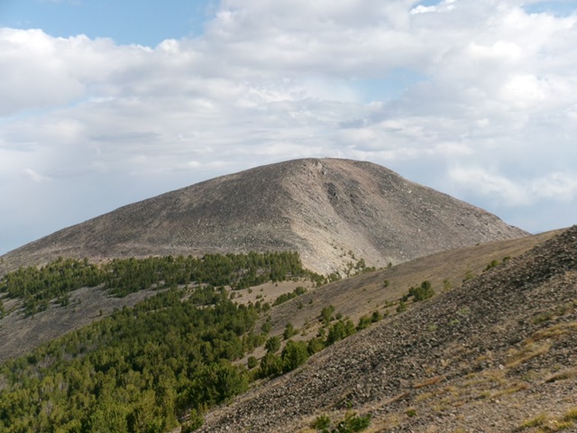
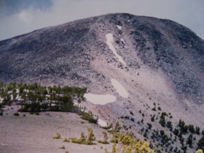
Sheephorn Peak and its steep east face (in center and right of center), its northeast ridge (skyline right of center), and its south ridge (skyline left of center). Livingston Douglas Photo
Access
Nez Perce Lake Trail [(A)(7)(a) on Page 314]. This is a very rough road and you may not be able to reach the trailhead without an ATV or MC. There are private land issues in this area, so be careful. Here are more specific driving instructions as of 2025. From ID-28 about six miles south of Leadore, turn west onto [signed] Tex Creek Road and reset your odometer. After about a mile, Tex Creek Road (a well-maintained county road) turns left/south. At 1.8 miles, reach a cattle gate (open). The county road now crosses private land, so stay on the road (as the signage indicates).
The road turns right/west then left/south. At 3.3 miles, reach an unsigned road junction. A private ranch road continues south briefly to a ranch at Cold Spring. Go right/southwest at the road junction onto [unsigned] FSR-212 and reset your odometer. This is a somewhat rough, rocky 2-track desert road. At 1.0 miles, reach a cattle gate/fence (and nearby pond) with “No Trespassing” signs on the cattle fence. However, FSR-212 is a public road and access is permitted to cross this small patch of private land.
Go through a metal cattle gate after crossing the private land. At 2.3 miles, reach an unsigned road junction. Go straight to stay on FSR-212. The road now gets rockier, narrower, and a bit steeper. At 2.8 miles, reach a metal cattle gate. At 3.1 miles, there is a campsite on a spur road to the right. At 3.4 miles, park in a roadside pullout unless you have a narrow, high-clearance, 4WD vehicle or ATV. This spot is at 7,097 feet and 44°31’20.5”N, 113°21’00.2”W].
This is the first leg of a 2-peak adventure that includes Sheephorn Peak and Timber Creek Peak (10,557 feet). It covers 10.5 miles with 4,175 feet of elevation gain round trip.
East Face/Northeast Ridge, Class 3
The Climb
From the Nez Perce Lake trailhead, hike southwest up narrow FST-212 all the way to Nez Perce Lake. Nez Perce Lake was about 2-3/4 miles from my parking pullout on FSR-212. The trail is well-beaten and easy to follow except for a few sections that are cairned. However, it has not been maintained for years and has at least 30-40 trees that have fallen across it and must be climbed over or circumvented, especially higher up. The trail is persistently steep and is somewhat rocky. It is mostly forested and has a few switchbacks. The trail drops 75 vertical feet about halfway to the lake and has a final 35-foot drop to Nez Perce Lake. Nez Perce Lake is a disappointment. It is only partially full and not very aesthetic.
From the end of FST-212 at the southeast corner of Nez Perce Lake, hike northwest along its shore then head left/west and cross a small inlet stream to reach the base of a rocky shoulder. Scramble west-northwest up a steep face of talus/scree for about 250 vertical feet to reach the crest of this shoulder. The shoulder now becomes forested and is not difficult. Bushwhack west-southwest up the shoulder to reach open, rocky terrain. Descend about 20 feet and cross a rocky gully to the right/north on large boulders (not fun). Continue scrambling northwest then north on the right/north side of a gully of loose scree/gravel. Do a diagonal right/northwest upward climb through a forest of scattered pines on less-steep, less-rocky terrain to reach the northeast ridge.
This Class 3 scramble is on steep, loose scree/gravel with some pine duff and some trees to grab onto. Look for embedded rock for better footing. The final push to the northeast ridge is a talus scramble in open terrain. It is very steep. Once on the northeast ridge, follow the ridge southwest up mostly boulders (and some talus) to the summit. This upper section goes at Class 2+. There are no goat trails to help. The summit of Sheephorn Peak has a massive summit cairn, a few surveyor’s cairns, a USGS benchmark, and a triangulation post with lots of wiring.
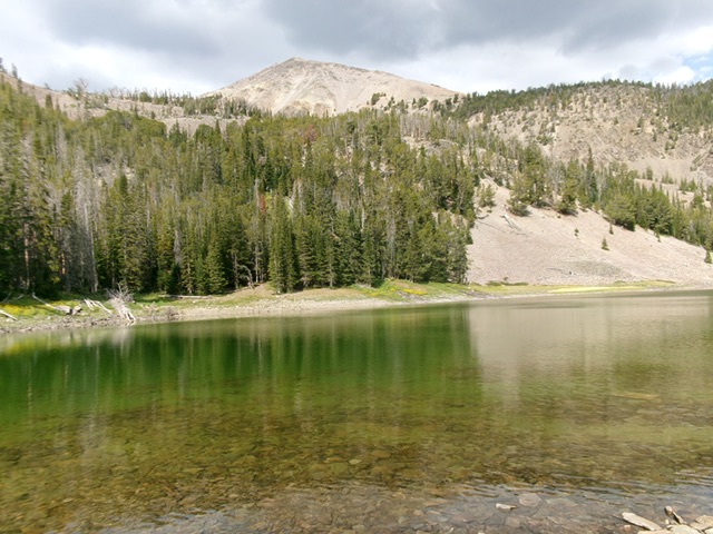
Sheephorn Peak (just left of center in the distance) as viewed from Nez Perce Lake. This was the starting point of my off-trail climb to the summit. Livingston Douglas Photo
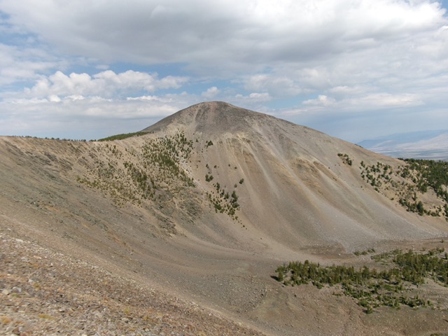
Sheephorn Peak and its steep, loose east face. This was the first leg of my ascent route, which ascends diagonally right up through the pines to reach the northeast ridge (the skyline). Livingston Douglas Photo
South Ridge, Class 2+
The Descent
From the summit, head northwest across the summit plateau. Descend south in Class 2+ boulders and talus to reach a patch of pines. Bushwhack down through this easy forest to the open gravel of the 10,140-foot connecting saddle with Timber Creek Peak. This concludes the first leg of today’s 2-peak journey. Timber Creek Peak (10,557 feet) is up next.
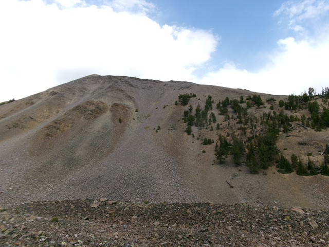
Sheephorn Peak and its south ridge (dead center). This was my descent route. Livingston Douglas Photo
Sheephorn Peak. Rick Baugher Photo
Additional Resources
Regions: EASTERN IDAHO->Lemhi Range
Mountain Range: Lemhi Range
Longitude: -113.40509 Latitude: 44.51079