This backcountry road system traverse crosses the Owyhee Mountains between Oreana, Idaho and Jordan Valley, Oregon. Although not publicized like the Owyhees Uplands Backcountry Byway, it is a scenic route that traverses through the heart of the range crossing mountain passes, sagebrush flats, numerous drainages, and remote ranches as is works its way between the Silver City Range and South Mountain.
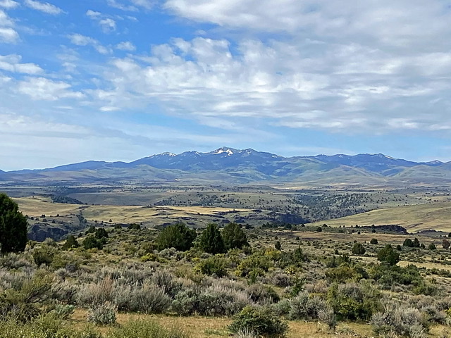
South Mountain as viewed from the road
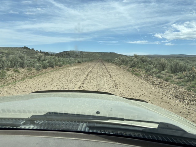
The road is graded gravel, with bridges and culverts for all stream crossings for its entire distance of 52.0 miles. In May 2021, there was only spot where there was a puddle in the road and it was easily bypassed. This road does traverse high desert country and users should be prepared for adverse conditions. Let someone know your travel plans and expected return time. There are no services along the road. There is no cell phone coverage. Start with a full tank of gas and carry plenty of water. Make sure that your spare tire is properly inflated and that you know how to change a flat tire. Be prepared if you become stranded (extra food and clothing for inclement weather). This road system is not open for its entire distance during the winter.
There are signs at major intersections which point toward Oreana or Jordan Valley depending upon your direction of travel. Still, this route is not frequently signed. Thus, you should have adequate maps to find your way without relying on the infrequent directional signs. This route is not recommended for the directionally challenged. Finally, this road system crosses is a lot of private land. Please respect private property and avoid trespassing. The BLM Surface Management Status Map (Triangle 1:100,000) shows land ownership and is available from BLM offices.
- Oreana 0.0 miles. Just south of the Catholic Church, turn west/right onto the Bachman Grade/Triangle Road.
- Toy Pass 14.0 miles. The road up to the pass is often punctuated by plenty of washboard sections. There are no guardrails. Toy Pass is a high and windswept crossing of the main Owyhee Mountains Crest. Once over the pass, the road is designated solely as Triangle Road as it descends to the south.
- Spencer Reservoir 24.0 miles. There is no camping at this reservoir which is completely on private land. The views of the Owyhee Mountains’ Silver City Range really start to open up.
Flint Creek Road 25.0 miles. Just south of the reservoir, the route reaches a signed intersection. Turn right/west. The road is now designated as Flint Creek Road. - Jordan Creek 37.0 miles. Flint Creek Road reaches Jordan Creek and a large area of ranch land. The road follows the creek for a good distance before once again climbing out of the drainage to traverse higher sagebrush-covered slopes.
- Pleasant Valley 42.0 miles. The road descends down into Pleasant Valley which straddles the Idaho/Oregon border. Turn north and follow Pleasant Valley Road north to Jordan Valley, Oregon in 9.7 miles.
- Jordan Valley, Oregon 52.0 miles. Gas and food are available if you arrive at a decent time.
A few other things of interest . . .
Revenge of the Sage Grouse: The BLM has instituted the Bruneau-Owyhee Sage-Grouse Habitat (BOSH) on its lands within the Owyhee Mountains. As a result, you will see large expanses of land littered with juniper trees which have been purposely cut down. The BLM explains the purpose for this project as follows
“Western juniper is native to southwest Idaho, but its occurrence is normally scattered. In recent decades, juniper has begun to spread and compete with sage-steppe vegetation for water, nutrients, space, and sunlight, while also altering the natural wildfire cycle. Wildfire is a primary threat to sage-grouse habitat. Under today’s decision, the BLM will cut selected juniper trees encroaching into the sagebrush and grasslands, focusing on areas around sage-grouse leks and the corridors between them.”
I will have to defer to the science behind this program but I will warn you that the dead trees are not attractive.
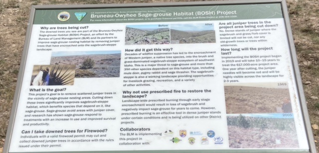
There are three identical signs along the route explaining the program.
Flint Townsite: The road passes south of the little-known mining ghost town of Flint. The townsite is on private property. There reportedly are several buildings remaining from the town’s heyday when the population exceeded a thousand people.
Oreana, Idaho. Oreana has few buildings but one worth visiting is Our Lady Queen of Heaven Church. You cannot miss it as there is little else left in Oreana. The church is listed on the National Register of Historic Places. Unlike most Owyhee Mountains towns and ghost towns, Oreana developed in response to the establishment of cattle ranches in the area during mid-1860s. Reportedly, a building was moved from Silver City to the Oreana townsite in 1882. This building became the Oreana Hotel. Three years later, a post office opened. Around 1892, a general store was constructed in town. A saloon, blacksmith shop, a livery stable, and a school soon followed to serve the residences and ranches. The general store, which was built out of local stone, eventually closed. It was subsequently donated to the Roman Catholic Church and remodeled into the quaint Our Lady Queen of Heaven Catholic Church. Service dates and times are usually posted on the door.

Mormon Crickets. It is not unusual to run into massive infestations of these beasts in the Owyhees in May.
The ground near the Triangle junction was covered with Mormon crickets in mid-May 2021. This infestation covered the road for over five miles.