Mountain Range: Lemhi Range. Map: USGS Gilmore
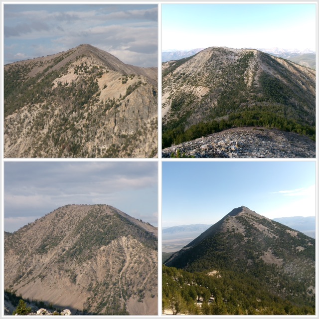 This trip report covers my 4-peak adventure which encompassed 11.5 miles with 4,600 feet of elevation gain round trip. Peaks climbed: Negro Peak (10,573 feet), Smithie Peak (10,263 feet), Peak 10336/Deer Creek Peak, and Peak 10177.
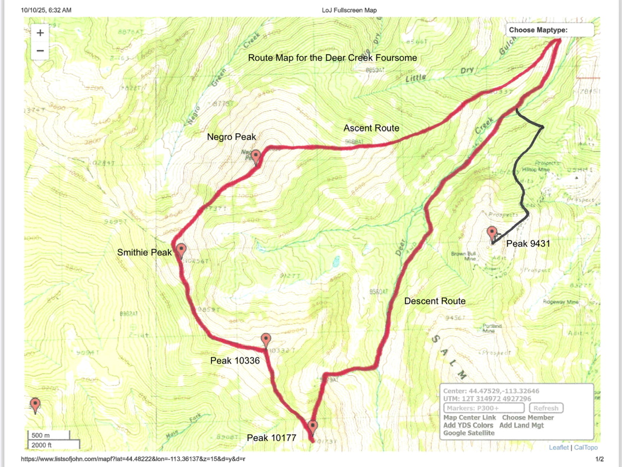
Route map for the Deer Creek Foursome (red line)
Access
Deer Creek Trail [(A)(6.1)(a) on Page 314]. Deer Creek Road/FSR-160 is a brutal road and, except for the first mile or so (up from Junction 6836), is only suited for ATVs and MCs. Prepare to hike most of this road. It is seldom used by motorized vehicles of any kind anymore.
Map Updates
There is a helpful, unmapped 2-track that heads up the lower section of the east ridge for just over ½ mile. The USGS topo map also fails to show the old road (now a foot trail) that continues up Deer Creek well past the two old cabins where the jeep/ATV trail ends at about 8,360 feet.
Negro Peak (10,573 feet)
East Ridge (Class 2+/3)
The Climb
Drive (or hike) up Deer Creek Road to an unsigned road junction at about 7,550 feet. Go right/west here onto an unmapped 2-track that quickly reaches the crest of the east ridge. Thanks to the old 2-track, game trails, and an easy pine forest, the east ridge is an easy climb early on. Higher up, the ridge terrain has a rockier base and there is a section of thick-ish pines, firs, deadfall, and rock. The ridge wiggles a few times and becomes rounded and less well-defined.
High up, the pines become more scattered but still persist far higher than you would expect. Finally, the pines disappear and the ridge becomes a Class 2 scramble up lichen-covered quartzite boulders and talus. Reach a flat, easy area at the north end of the summit cap. Scramble along a narrow ridge crest that heads south over Point 10555 (a rocky outcrop). The high point of Negro Peak is at the south end of the summit cap.
Southwest Ridge (Class 2+)
The Descent
From the summit, descend southwest down through talus and over a ridge tower/outcrop. From there, bushwhack down through a thick-ish, but easy, pine forest to reach the 9,737-foot connecting saddle with Smithie Peak (10,263 feet).
Smithie Peak (10,263 feet)
Northeast Ridge (Class 2)
The Climb
From the 9,737-foot connecting saddle, scramble southwest up a ridge crest of easy talus/scree with some scattered pines. The ridge bends left/south high up. Scramble south in easy talus/scree and tundra to reach an initial rocky point. Continue south to the cairned high point of Smithie Peak.
South Ridge (Class 2)
The Descent
From the summit, follow the ridge crest of talus/scree and scattered pines south then south-southeast down into a pine forest to reach the forested, 9,859-foot connecting saddle with Peak 10336/Deer Creek Peak.
Peak 10336/Deer Creek Peak
Northwest Ridge (Class 2)
The Climb
From the 9,859-foot connecting saddle, scramble southeast in a mix of ridge pines and rock to reach a left/east-southeast bend in the ridge high up. Scramble across open talus/scree and easy tundra to reach the forested summit of Peak 10336. The cairned high point is at the east end—a ridge corner in an open spot.
Southeast Ridge (Class 2)
The Descent
From the summit, descend south then southeast in a mix of rock and pines to reach a small, semi-forested, 9,860-foot connecting saddle with Peak 10177.
Peak 10177
Northwest Ridge (Class 2)
The Climb
From the 9,860-foot connecting saddle, scramble southeast up a steep-ish, loose ridge of scree/gravel and a few scattered pines, using zig-zagging goat trails to help advance higher. Once on the easier summit ridge crest, head right/south through a pine forest and easy ridge rock to reach the high point of Peak 10177 at its south end.
North Ridge (Class 3)
The Descent
From the summit, return north on the ridge crest down to a ridge juncture at 10,100 feet. Head straight north-northeast and descend a steep ridge of pines, boulders, and loose scree/gravel (Class 3). Lower down, the ridge fizzles out in a steep, loose final descent in talus, scree, and gravel. Enter the wide gully that heads right/east down to the Deer Creek drainage. Cross to the left/north side of the rocky gully and follow its left/north side on the edge of the pine forest as you head east toward Deer Creek.
Find an old road bed (now a foot trail) in a dry creek bed before reaching Deer Creek. Follow this road bed (which, at times, is only a foot path) as it soon crosses to the right/east side of Deer Creek. The foot trail soon reaches two dilapidated old cabins and a trail sign. You have reached the top of the jeep/ATV trail that is FSR-160/Deer Creek Road.
Follow this rocky jeep/ATV trail down past a nice cabin in an open meadow. Continue down the right/east side of Deer Creek on the old road. The road soon drops left/west down to ford Deer Creek. Bushwhack downstream a short distance to find tree logs to cross Deer Creek. Once across the creek, return to the road and follow it down to your parked vehicle.